Maurice 2013 Sept

Mt Maurice: the Mystery of the Missing Mountain Sept 2013

View to Mt Victoria and Mt Albert

Is this the place? Nothing much matched up with the book (Abels Vol 1).
“17 kms along the road”, it said, but was that counting from the Targa (Chapel Hill Rd) or the Diddleum turn off? The book was, alas, ambiguous. (Answer: it was counting from Targa).
The mountain, too, was “ambiguous” – ‘shy’ the book dubbed it. Reclusive, elusive, downright evasive are other possible descriptors. Was there actually a mountain hiding behind those trees? We’d seen no sign of it so far whilst driving.
We hadn’t even been supposed to be on that particular road: there was a nasty “detour” sign that I determinedly ignored, knowing that if a mountain existed, it lay straight ahead. Perhaps Mt Maurice was nothing but an in-joke for the cognoscenti?

Welcomed after all
Over St Patrick’s River I drove – a good sign, as it is promised by the book – but it was still possible that I was making a parallel error. Nothing else matched, as we had been promised wet sclerophyll forest – one of my favourites with its refreshing, soothing greenness – but it hadn’t really been in evidence, and as. a special alternative, we were proffered a kind of autobahn – a dry, wide, grey, levelled-out-of-all-individuality road – with dull grey corpses of trees to match, and a boom gate forcing us to park near the river.
I thought of William Blake’s poem, Garden of Love, which depicts a somewhat similar situation, reciting it to myself as I walked:

I went to the Garden of Love,

And saw what I never had seen:
A Chapel was built in the midst,
Where I used to play on the green.

And the gates of this Chapel were shut,
And “Thou shalt not” writ over the door;
So I turned to the Garden of Love,
That so many sweet flowers bore;

And I saw it was filled with graves,
And tombstones where flowers should be;
And Priests in black gowns were walking their rounds,
And binding with briers my joys and desires.

Just substitute “And trucks with their drones felled trees with loud moans” for the second last line and you have a revivified Blake over two hundred years down the track.

Ancient mama of the forest. A VERY old myrtle

So, we marched up this ugly scar feeling the force of “Thou shalt not” and the absence of beauty where it had once flourished, trying not to attend too much to the corpses of trees and the couple of remaining desiccated, dusty imitations of tree ferns that had somehow missed the shove to oblivion.

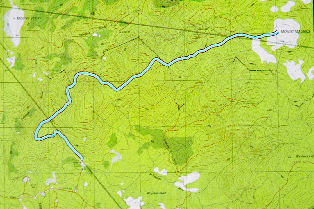
After about 40 mins, I got out my gps to have a check while we walked. This was interesting. We were on a highway that was not on the map, and the road on the map was nowhere to be seen. Hm. (See map/ route below). Better pay careful attention to contours now. They’ve completely changed the forest. Contours roughly in order at this stage, but we were about maybe 400 ms south of where a road should be. I switched map scales, but the next map said the same. Maybe the original drawers of the road had been careless and just stuck in an approximation. Nonetheless, contour-vigilance was required in case this autostrada led to nowhere that I wanted to go.


After 58 minutes (putting this in, in case it is helpful), we came to a post with two reflectors on it. No track corresponded to my gps location, but I decided the contours and general direction were good, so we’d take it. Three minutes more, and we found a sign that said: “Welcome”. We just about roared with laughter. I photographed it in case it was the only nice thing we should find this day. We still hadn’t seen any sign of our mountain. This was a real exercise in faith.

It was so much nicer once we’d left the wide, levelled road. There were now some soft, mossy sections under foot and the myrtle count increased. Birdcalls could be heard for the first time. And we had shade, blissful, soothing shade. Ahhhh. This wonderful section of forest lasted a full twenty five minutes. The trees were huge – tall, wide and stately. Ents watched our progress. Every now and then there were magnificent pink granite tors covered in moss. I delighted in them. The only problems were that we still hadn’t seen a mountain, or even a hint of a mountain, and we also hadn’t found the sort of contours that a mountain has. The map had a little gang of them, huddling together before the summit, and we were just gently easing our way along, only vaguely upwards. Somewhere we needed to encounter and cross contours if we were to climb a mountain.

All too soon our lush green primeval forest ceded to dry sclerophyll shrubbery (after 25 mins), and after another five, we encountered our first scoparia bush. Now we were on a flat, wet patch with not only scoparia but also fallen dry enmeshing bushes that resisted our progress. And there ahead, at last, were a couple of contours and a knob that I guessed was our mountain. Hoorah. Through a short but beautiful section of quite open and tall melaleucas, we hit wind and more scrub, and three minutes after that we were by the trig. I could see that much better views could be had from the other, non-summit end of this dome, so we fought scoparia and wet pools and went over. Yes, great views of all the surrounding mountains, but in particular of Mt Victoria, Albert, Saddleback, Ben Lomond, Barrow and Arthur – and we could see the sea.  We photographed, snacked, and descended. The descent took a couple of minutes longer than the ascent, which roughly translated means I was hungry.

St Patrick’s River crossing is a beautiful spot (and would make for great camping if you’ve come up from the south to bag this peak). It would have been great to have lunch there, but I hadn’t packed any, so drove back to Launceston in time for a late lunch instead.

Saddleback 2013 Sep

Mt Saddleback   12 Sept 2013

Victoria and Albert in the distance
“How long does the book say it should take us to climb it?”, I ask as we near the parking spot for Mt Albert.
“Two hours.”
“Oh. Swear.”
We have one hour’s light left. We can’t undertake a venture of possibly four hours if the book’s right with those statistics at hand. I slam on the brakes and do a U-turn. “Can you check Saddleback? Should be page 32.”

“One hour.”

“OK. Let’s hope we cut the book time as normal.” There’re still a few more kms to drive, and the sun will set in an hour. This is ridiculous, but I’ve just driven for two hours, so I am intent on summitting something.

As we approach Saddleback, there’s a tree over the road so we have to walk from there, adding time to the ascent. Great. At least we’re underway, and I note with a little dismay that the cairns are as subtle as cairns can be, and the “track” is even subtler. We will be descending in the dark for sure unless we work miracles on a speedy ascent, and I don’t like my chances of finding these cairns in the dark. My husband has coordination problems. Is he going to be able to clamber  over these big rocks in the dark?? These are questions to be dealt with later. Right now I have summit-angst and press towards the goal with my hapless husband in pursuit.

The gradient is wonderfully steep. What a fun mountain. We go straight up on all fours – but not for long. After 22 minutes I am cresting the flatter section at the top. Good. We may make it in the light yet. Unfortunately, however, B has dropped behind on the steep part and then got lost in the confusing section on the plateau, so I have to go back and dig him out of the thorn and scrub maze in which he had got himself entangled. More precious time lost.

Arthur
Once it was flatter, however, he kept up and I slowed down, and we managed to mount some wonderful, dramatic rocks that would serve as a summit for him while I went on to the real one that still lay about 200ms further on (in length, not height).
Now it was my turn to waste precious time. I went to take a photo of where I was leaving him, which had wonderful views to the east and north, and realised that I had on my telephoto rather than my wide-angle lens. Stop, change (I had brought up three lenses). I kept taking photos … more time lost. Then, while forging on to the monstrous real summit structure, my camera jolted, just a tap, but the lens cap and polarising filter flew off and down a crevice. More time lost while I searched. I ended up spending far longer on the summit than intended, although even so, not nearly long enough for such a worthy mountain, but by now the sun was setting in earnest, and I still had to get my husband out of this rock and scrub maze.

Barrow and a small bit of Lomond
 The forecast for Cradle was minus four over night; even Launie was expecting minus one. This was not a night to be trapped on a mountain. Haste, haste. But the sunset was sooo beautiful. I collected B and we began our way down, but I just had to stop while we were still high for one last series of photos after the sun had slid behind Lomond and Barrow, leaving behind a sky of gold, and Arthur became a purple silhouette with pink background. Even if we did have to stay the night up there, I decided, it was worth it to witness that particular sunset.
Bruce looked a bit impatient as I clicked away. Had I forgotten my great urgency? Well, it was a case of “might as well be hanged for a sheep as a lamb”.  There was no way we were going to get down before dark – it was basically dark already – so why not at least take a few photos? He wasn’t exactly in a position to criticise me for holding him up, and soon enough we were on the treasure hunt that the trip down became – each cairn evoking a cry of victory as it was found. The dark grew darker, but I kept managing to find the next cairn. I was immersed in a world of extreme concentration as I read the bush for signs of usage. There was, however, only one spot where I was in doubt, thinking the land looked better to the left than either down or right. At that point I consulted my gps device for the first time, and a retracing of our tracks dictated that we should go slightly right instead, continuing to drop contours steadily. We obeyed my screen.
We did have head torches, but chose not to use them, as we didn’t want them destroying our night vision. They were there for a worst case scenario. On we went, until my victory cry. There was the road. High fives; smiles. Oh what a great adventure that one had been !!!! Bring on the next one.
Another two hour drive home made for a late dinner. I like at least a 1:1 ratio of driving to exercise. This trip was even worse than 2:1, but no matter. We love a grand adventure, and Saddleback provided that for us, for sure.
Bruce commented later: “I wonder what the doctor who told me to stick to flat surfaces with a handrail would say to that one.” (He has Parkinson’s disease).
“He’d never catch up with you to do the saying”, was my response.

Tyndall 2013 Sept

Mt Tyndall   7-8 Sept, 2013

A cold start to a wet mountain

The day for this summit attempt began with a chilling wade through a swollen creek, after which I really needed to be allowed to move at a pace that kept me warm, whereas the others wanted to take the incline at a pace that would have had me shivering to death. The leader agreed to let me do my own thing so I could keep warm. As a result, the first day of this trip, which included, at last, a summitting of Mt Tyndal, was done solo. Luckily I had my gps for the summit, as there was a total white-out, with snow blowing all around me, and only it could confirm that I was standing in the right spot (and only it could guide me to the spot, as I could see nothing but snowflakes).

I returned to our designated camping spot and ran on the spot and danced to keep warm until the others returned.

An eagle was my lunchtime companion – but it looked to me as if I were to be the lunch.

I have NOT used zoom on this guy. He thought I was a lamb, I’m sure. I have another photo of him just above me, staring straight at me, looking poised to attack.

We camped near here.

Colourful beetles


View from near the summit
The others returned soon enough, and we began to prepare our meals together (those of us who could stand being outside),  huddling around the gas flame of the cooker, pretending it was providing a greater warmth than the flimsy requirement of boiling three cups of water. I did a bit of dancing to keep from freezing into a solid block, and was hugely appreciative that our coordinator boiled extra water for me, so that I didn’t have to fight my stove with hands that weren’t really working any more. Had she not done that, I would have just contented myself with snacks for dinner – not nearly as nice.

 Next morning
We retired to bed early, as after the eating, there was no more point in standing around getting colder while the snowflakes fell around us. My feet had been sopping and frozen all day from the first river crossing – about five minutes into the walk – so I was quite busy in my tent, massaging them to try to restore some life, and then doing a series of exercises to warm up my torso: glute raises, bicycles, crunches and more. After three and a half hours of concerted effort I was warm enough to try sleep. Success. I slept for four hours, but then woke up cold again, so repeated the procedure for a couple of hours, dropping off again at about 4.30. Considering how cold it was, and that it snowed all night, I thought it was pretty good to get even that much sleep. I wasn’t expecting any.

The snow next morning was beautiful, and duly photographed, before the dreaded job of depitching had to begin. Why dreaded? Because I would need to don saturated, snowy socks and sodden, icy boots and drenched, unpleasant gaiters in order to do the job. It was not a joyous occasion.

The next hour and a half were not the favourite moments of my life, and we’ll leave them without much comment here. We got there in the end, and could from the perspective of safety look back and declare it a marvellous adventure. That was my second attempt at Tyndall – both times in disastrous weather – so I’m very glad to have made the summit despite the blizzard. I want to return to see the view some day.

Murchison 2013 Jun

Mt Murchison   22-23 June, 2013

The weather forecast had a huge and wonderful high, all weekend. What should we do with this treasure? We had touched the summit of Mt Murchison, but not seen the view. Mt Farrell, when we climbed it, had also been clothed in a thick grey mantel. This would be the weekend to see the view. Off we set.
The trip there was so beautiful, we almost didn’t care if we never got to see a view. Every shrub – every blade of grass – was coated in a sparkling white rime. It was glorious.  We drove through fairyland to get to our mountain.
For the early part of the climb, one is in protective rainforest, but from the moment we emerged from the rainforest’s aegis, the rocks were covered in ice crystals, as below.

My husband had planned on drinking from creeks, and hadn’t brought any water. He was disappointed (in the liquid refreshments available, if not in the scenery). Every single water source, running or not so, was frozen solid.

Beautiful in an austere kind of way, but not much good for drinking

The going was pretty tricky, and became more so the higher we got. Below us, cotton-ball cloud filled the valley, shining glary white. As we neared the rather exposed shelf that my husband had crossed happily in the mist, I decided in slippery ice it would be too tricky, so I left him in a spot with a magical view, and dealt with the final section of ice solo.

Here is a photo of him waiting patiently taken with a zoom from the summit. It seemed from the top as if I could see forever. I photographed in all directions, but didn’t linger: i could see my husband, safe in the distance, but he might be getting cold. Time to go back and join him.
 Even halfway down, the views were inspiring.

And below are two pictures of Murchison taken the next morning. This is one glorious hulk of a mountain!!


We then went to Mt Reed that afternoon, and Mt Farrell the next morning, so they were all part of this trip, but I like to allocate each mountain its own space,  so I will give the other pets their own separate post.

Read 2013 Jun

Mt Read   22 June 2013
As said in the Murchison entry, these two mountains were done in the same weekend, but I decided to file them separately.
We climbed Murchison on the Saturday morning, and wanted to go up Read after lunch that afternoon, saving Farrell for the early golden light of the following day.
I had the map. We set out. It was not a case of veni, vidi, vici, alas. We were met with the “locked gates of Tasmania” phenomenon, and spent the next two and a half hours – longer than the ascent + descent of Murchison – trying to gain some kind of near starting point. Eventually, with light fading all too quickly, we dumped the car in the township of Rosebery, and set out. There’s a road all the way, so one is not going to get lost in the dark, and it was a glorious, albeit bitterly cold, evening.
Here is what we found: wonderful in short.

 Moonrise behind Murchison across the valley


Later, and looking towards the west