Barrow 2013 Jun

Mt Barrow June, 2013.

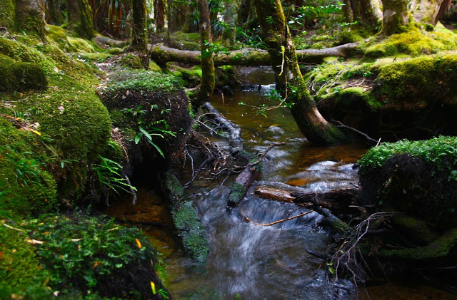
Today we accidentally climbed Mt Barrow – that is, we didn’t get to the top and say “Oh no. This is not Ben Lomond after all”; rather, we climbed it as a mistake in our interpretation of the weather, thinking the forecasted rain would spoil anything further afield. This was the ‘poor little sister’, the wet weather option. There were big clouds around. For this reason, we had only gone to the gorge in the morning – but I had not had enough exercise, so suggested during lunch that we walk up Barrow after a bit of a read. We packed our anoraks and more, and drove off. It is rather embarrassing to admit that, although we have lived in Launceston for 25 years, and although we quite often (so it seems) drive 4-5 hours to climb mountains down south, my husband has never been up Mt Barrow, and I’ve only run up it twice.


We parked at a kind of picnic hut thing down the bottom, and set out walking. I didn’t have a clue how long walking would take, but it was a rarely used road, so we could descend in the dark if necessary. Bruce was most unimpressed to be walking up a road, but I assured him we’d have it to ourselves, and we were there for the exercise, not so much for the scenery – it was only Barrow, after all. A car and a motorbike farted by after about 12 minutes. That did not augur so very well. Fortunately, after that my grand prophecy was correct.


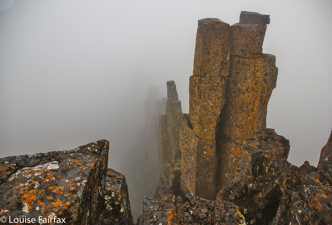
The higher we climbed, the lower the sun dropped, and the more spectacular the landscape became in the golden light. Whilst waiting for Bruce at the top car park, I sussed out how I would get to that alluring summit trig. All the space-age towers with huge circular ear-muffs or robot eyes looked like something from a sci-fi horror movie and quite spooked me, actually. In the end I did the rocky bit solo. The rocks were very slippery, the moon equipment foreboding. The promised clouds and nightfall were approaching too quickly.


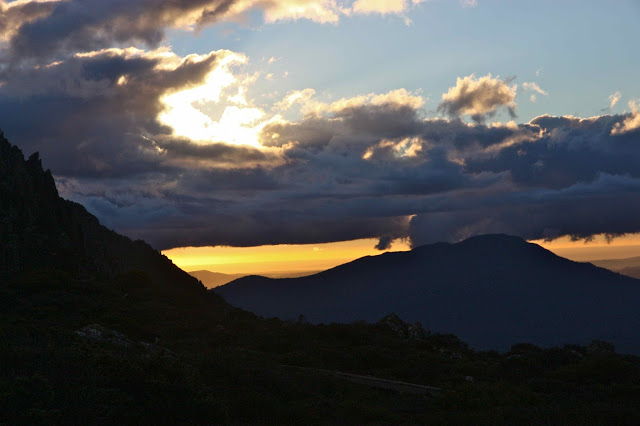
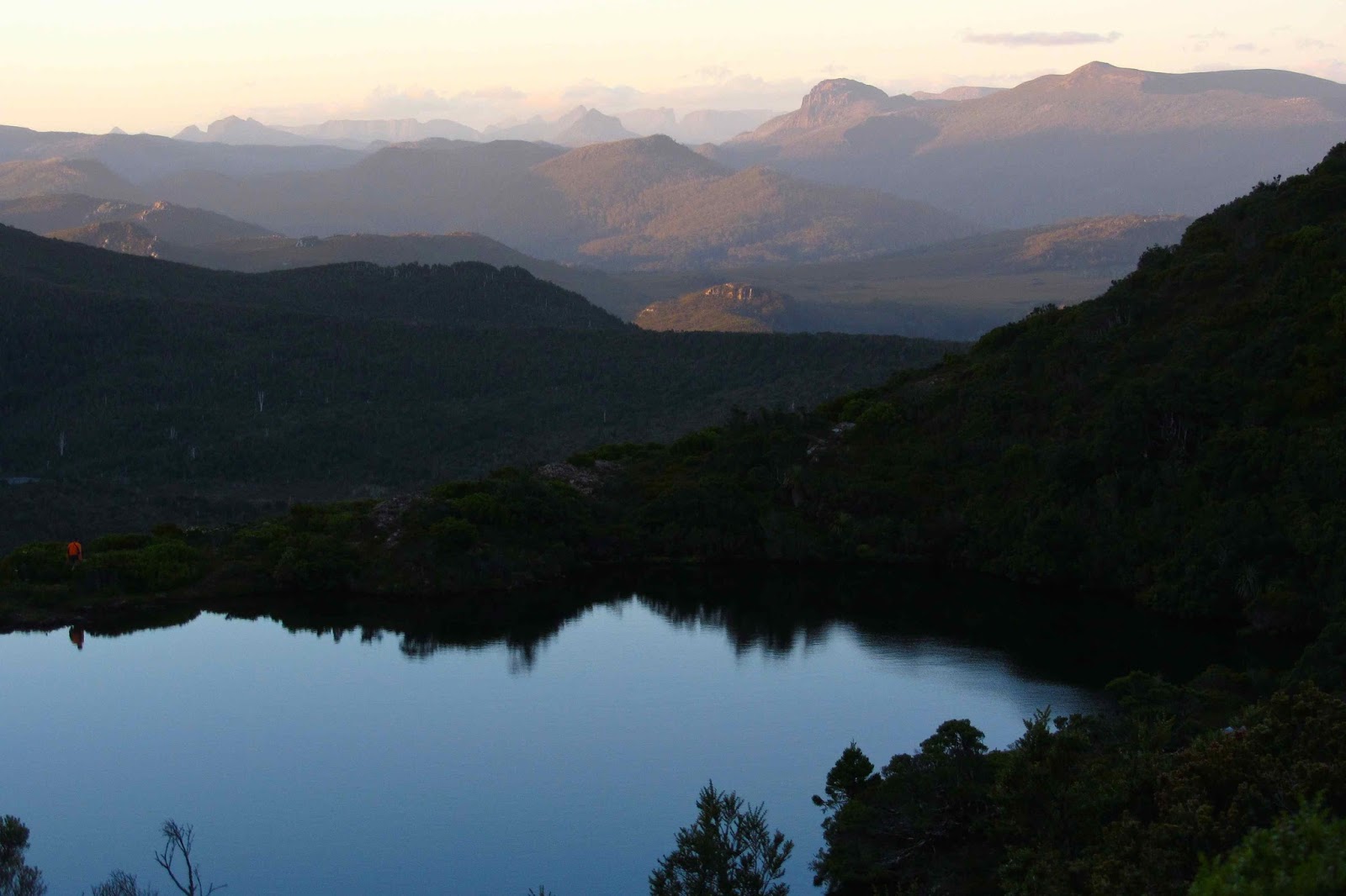
Our descent was absolutely magic. An imposing cloud mass had built up, but remained in a narrowish strip, and fiery rays of light projected in streams above and below the banks of louring grey to the west.


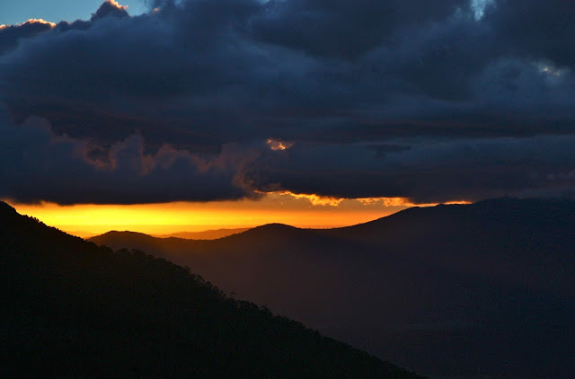
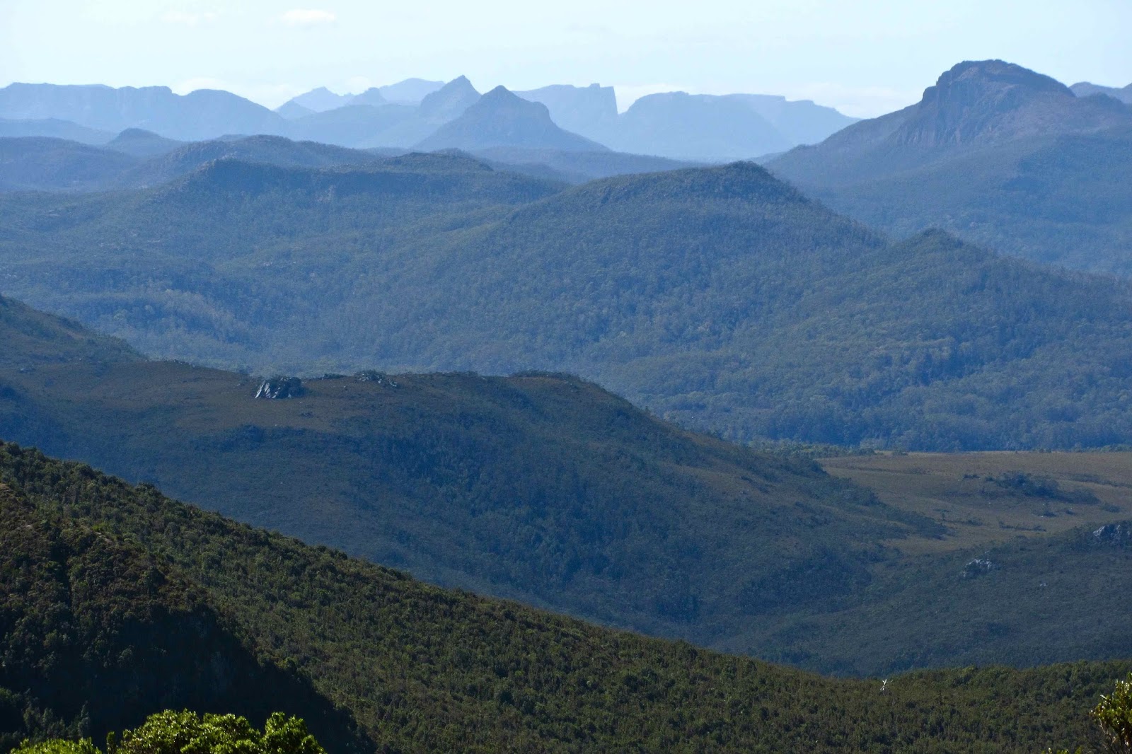
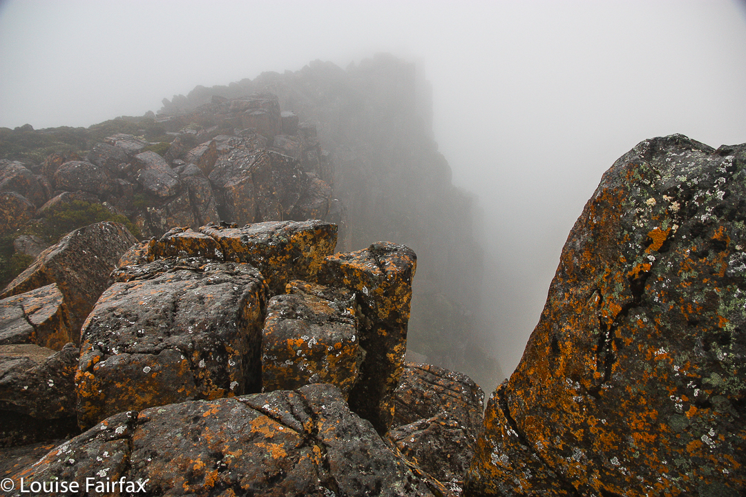
An eastern hump of dolerite cliffs (which faced west) took on an orange mantel for long enough for me to photograph it before it donned its dull night jacket. The ocean was clearly visible in the evening light, and the mass of mountains to east, north and west made wonderful silhouettes. No rain fell. We plotted our return as we drove home.


Beecroft 2013 May

Mt Beecroft   19 May 2013

Our trip to Mt Beecroft began early, so for a bit over an hour we drove past glorious white fields, the grasses in the ditches beside us sparkling with thick frost. The mountains were spectacular in air that sharp, with every shadow and indentation, and every sunny ridge perfectly crisp and clear.
 
We arrived at our destination car park (on the highest point of the C132, which goes past Cradle Mountain. It is 10kms west of the Cradle turnoff) just as the clouds did, and set out into a biting wind. It was so cold that I said we’d go for an hour, and if we were still freezing, we’d turn around, as it was obvious we weren’t going to see anything in cloud like that. The water on the pad was between ankle and mid-calf deep, depending on where you put your feet (hard to see, as the wind had my eyes watering so much I just stepped out and hoped). All the bushes were drenched, so our pants were very quickly sodden. After 15 minutes, however, we had gained enough height for the ground to be a little less sopping, and after 36 minutes we either crested a rise or rounded a corner or both, but suddenly our goal was visible not far ahead in a gap in the mist that suddenly and unexpectedly appeared. I photographed it in case it was the only photo for the day. Unfortunately, the glorious views that the Abels book promised us were not to be had, but the details closer to hand, seen through the atmospheric mist, more than compensated. We also revelled in the pylons of rock emerging through the swirling grey veil higher still.
 
Although we couldn’t see anything other than the rocks close at hand, there was a wonderful sense of space climbing the ridge – much like we have when in the Lake District, or emerging at the top of Moraine A in the Western Arthurs. We ate a hasty (and very early) half lunch (half, because we were cold once we stopped, and I wanted to get us up to the summit, and then out of the mist while I could still see something, and because we got so much in a single salad roll from ETC that I couldn’t even open my mouth wide enough to get the roll inside, let alone finish such a deliciously huge portion).
On the return journey, I wanted to stay wild and free, so diverged from the waterlogged trenches of the Penguin-Cradle track and opted for the greater sense of space on the ridge line – a drier and more wombat-filled option, even if slightly longer. There were some beautiful tiny fungi at the end – mostly mycena I suspect. Here is some lichen.
 
On the way home, we warmed up and broke the journey by stopping at Villaret, which we haven’t been to in ages. There we shared one cake. It was a (breathe in deeply so you can say it all in one breath) “warm chocolate whisky date and macadamia fudge cake with caramel-macadamia ice cream, salted caramel and macadamia slice, butterscotch sauce (with the ice cream) and chocolate sauce (with the cake), garnished with white chocolate leaves, strawberries, cream and spun sugar”.
We felt very satisfied as we continued the final hour home. Sunset over the river was pink as we pulled into the drive.

Drys Bluff 2013 Apr

Drys Bluff   28 April 2013  

Bob Brown’s here”, the excited whispers ran through the bus; heads craned to see. Pulses rose. This was going to be a fun day.
As we stood in a circle to say our names, you could feel that these adults were like kids needing to suppress giggles, although they did their best to introduce themselves with less of a teenie-bopper air than they felt. My pictures of them during the day have faces lit with huge grins. One said to me at one point: “This is such a cool club. Do you bring celebrities to every walk?”


I have known Bob for nearly twenty years, dating back to days when I was on the green ticket in two elections. Despite this loose acquaintance, I have never done anything with Bob that was not official, so even for me it was a treat to go walking with him, and to see him on more relaxed turf – especially nice to see him in the bush that he fights so hard to save. I sometimes fear that he’s so hard fighting he has no time to enjoy what he’s fighting for – and I feel guilty for enjoying it so much and never allowing enough time to fight properly for its existence. It’s hard to get the balance right.

We climbed up the Bluff to pretty specy views, and then some of us perfectionists in the matter of peak bagging set off across the horrid scrub for the actual summit. Bob, having climbed the good part about eighty times I think he said, and having also officially bagged the thorny castle of a summit, was happy to go straight down with those who still retained sanity. We met back up down the bottom, where Paul had lit a fire, Bob had brewed some tea, Caroline had brought several cakes, and where the laughter and chatter continued until after dark. Most of us came home with a little goody-bag of walnuts, courtesy of Paul’s efforts while we had been off, gallivanting on high.

Loddon Range 2013 Feb

Loddon Range: Loddon Bluff, Ronald Cross and Church Peak  23-4 Feb, 2013

The Loddon Range that we were to climb, as seen from the highway.
One of the advantages of being in a club is that you get to go to places that you would not have gone to if someone hadn’t indirectly (by putting the name on the programme) said: “Come here with me”. I read the name “Loddon Bluff”. I hadn’t been there, so signed up for the two day expedition that would see us climb every highpoint on the Loddon Range over two days.

The bush was thick. Very, very thick. The distances we covered were hilariously minimal given the time we took to do it, but with impenetrable walls of well-armed scrub, that’s what happens. I’m delighted to have done it.

We began with a descent – very short – a creek crossing, and then a long climb up onto the ridge. The going was not too bad in the rainforest, but awesomely shocking once we emerged from it, and from there to the top of the first of the peaks on the range (Ronald Cross). From that point on, however, the scrub – still thick – did not do as much damage to our progress (which was now ‘slow’ rather than ‘armoured fight’ stuff), and the views became extensive and impressive.
We could see Frenchmans Cap just across the Loddon valley below, had a new view of Slatters Peak, Diamond Peak, Mt Anne and more.
 It was fabulous being up so high with the world stretched out below. Most of us followed the ridge line over each high point until we were directly above Needle Tarn, which we dropped down to once we’d regrouped. Two took a shortcut – less scenic, but also, of course, less fighting – as one of them was suffering a bit from heat exhaustion. We all met at the tarn where almost everyone (not this wuss) went for a dip.

Needle Tarn in the evening.
The evening light after dinner was wonderful. I went off and climbed a bit around the place, sometimes photographing, sometimes just sitting on something and singing, enjoying the atmosphere. The others had retired so I had the known (or visible) world to myself.

Here is the evening light on Mt Gell 

Mt  Gell a bit earlier in the day
Here was our view back to the Acropolis, Geryon, Byron and more.
The grand Mt Anne was a pimple on the horizon, but a lovely one.
 The next day we got a very early start (in which I discovered, or rather re-discovered, that I am a slow eater).  This was good, as the day was a very hot one, and we went about twelve hours without water (other than what we carried). At least we got in some work before the sun began attacking. It wasn’t far to go to get to the end of the range, but it took a very long time thanks to the rugged nature of the various lumps and bumps. We climbed Church Peak and Loddon Bluff before turning around. Already by about ten o’clock, we were hot and bothered. We dropped down to a tarn, but it was merely a mud slosh, and utterly uninviting as a source of drinking water. The leader didn’t want to drop four contours to return to our overnight tarn, so we stayed high. I hid behind small bushes in the breaks to keep the sun away. We all husbanded our water very carefully – except one person who drank his supply early and then wanted to “borrow”.
The route yet to be undertaken, stretched out towards the bluff
The others approaching the Bluff itself, endpoint of this excursion


Looking back along our travels
Despite needing to guard our water and hide from the worst of the sun, the trip was wonderful. How lucky we were to have two days so clear and views so grand. We fought the scrub some more until we at last reached the respite of the rainforest below the other end of the ridge. We all enjoyed the refreshing creek at the bottom, of course, trying not to drink it completely dry.

Acropolis 2013 Jan

Acropolis  12-13 January, 2013.

Summit view
“We’re going up the Acropolis this weekend.”
“Lucky you. The weather’s looking great.”
Yes, the forecast was pretty good. Some rain scheduled for Sunday afternoon, but the main action would be over by then. We’d probably be driving home.
It was hot as we packed. I not only threw in a bikini for Lake St Clair, but also a Speedo for good measure, in case it was a little cooler.
We went through our gear.
Gloves? Na, well, better take one pair, but not the usual three.
Don’t bother with spare Helly longs or top. Just the lightweight half-sleeping bag will do.
Sleeping sheet? Yeah, we might get pretty hot and smelly, so that will be needed.


Our plan was to camp up high on the shelf below the cliffs to get great sunset and sunrise photos. Even as we sat impatiently on the ferry listening to the driver and tour guide who said: “There are rainforest trees out there; don’t know their names” to the lucky tourists, the clouds were rolling in. The driver knew I was in a hurry to get started with all we had to do after the boat trip, -now running about 45 minutes late – and was enjoying dragging the journey out as much as possible to thwart me. He looked on bushwalkers with scorn. Adding to the delay, he stopped the motor in case anyone wished to photograph the featureless (in this light) blanket of green out there beyond the water.


Pine Valley – en route
Finally released from our boat prison, we raced up the track to Pine Valley, and at last embarked on the final stint through the glorious forest to the top. It was a shame to rush through such scenery, but the ferry driver had created our haste by squandering our time in approach. As we gained the shelf, we could hear the wind roar and we became encinctured in mist. The Acropolis was just a hint in the gloom of grey vapour. There would be no sunset tonight. There was no view tonight. It was raining as we pitched tent and cooked our meal. We began to regret the lack of spare gloves and normal bags. I wore almost every item of clothing in my bag to bed, with a spare pair of socks for a pillow. We lay in our cosy tent listening to the thunder of the wind outside and the light patter of rain. Hopefully the morning would bring a pleasant surprise. I love lying in the shelter of a tent and listening to the wild elements raging outside. We slept well.


Morning did not bring a pleasant surprise. Oh well. We didn’t need to get up early to catch the glorious first rays of sun on the surrounding mountains, or gain the summit while the peaks were still silhouettes in the early light. We didn’t bother getting up until nearly 7.  Up we went through the mist.


My husband doesn’t have reliable use of his hands, so regrettably, when we were only maybe ten minutes from the top, where there was a climb up the slippery rocks that was too challenging for a person with no fine motor control, he chose to stay perched on his ledge while I continued to the top. I called to him from the summit to let him know I was there, but he was too far away to hear that – and perhaps the thick mist swallowed my voice.


Coming down I was quite apprehensive, as the thick mist obscured all visibility, and I was mildly concerned about not finding the correct chimney that would lead me down. I realised that, as B could not get up to save me even if he did hear me yell, if I fell on the slippery rocks and broke something, I would be lying there in the rain for a very long time before anyone could help me. I was very cautious in my footing. THANK GOD (or, more correctly, thank you people, whoever you are, who put cairns out there!!!!)  for the cairns that appeared now and then in the otherwise  featureless environment, and a special thanks for the one with a stick on it. I had paid special attention to it on the way up, and was not going to attempt to go down until I sighted it again. There were two tricky sections on the slippery rock below the summit area on the way up, but fortunately they were fine on the way down. I would be interested to see someone with a beer belly doing one of the tight rock-hugging sections that had a drop below that could severely damage anyone who fell. I am pretty skinny and wanted every centimetre of the room my slender frame provided.


Back down at Pine Valley
So, we didn’t get sunrise or sunset or a swim (unless you count wading through water on the track), but we did have a fun adventure, and we loved the shining green of the forest, and the atmospheric mantel of mist that, despite obscuring all hint of a view, lent the rocks a special magic.