Gnomon, Dial and Montgomery 2014 Jan

Mts Gnomon, Dial and Montgomery, 1 Jan 2014.

Path to The Gnomon

What a great way to start the new year: with a walk. Whilst it seemed from listening to the radio that the rest of Australia was on fire, we gathered our coats, rain jackets, Helly longs (top and bottom) and more, and set out for the coastal town of Penguin. Alas, I neglected to bring my waterproof pants and gloves, as this was summer, so I was in beach mode. I froze. Luckily my husband had a spare pseudo-down jacket he could lend me. It was all on tracks, so we could move quite quickly to keep warm (which is part of the reason I had not brought as much cold-weather gear with me).

Gnomon summit rock (which I climbed, of course)

As I walked along the pleasant track listening to the birds, I reflected on the fact that I would much rather be doing this beautiful three-mountain walk in these drizzly conditions than in the summer heat. The greens and browns glistened, and although we couldn’t see the nearby sea, we had wonderful vistas out into the atmospheric wilderness below that hinted of hidden beauty behind the low lying clouds. Mist swirled around the moist, mossy rocks. Stylidiums, goodenias, hakeas and hibbertias, inter alia, coloured our route.

Dial Range Ridge track connecting the mountains

Although none of our mountains was high in any absolute terms, each had a nice little pinch to get to the top, so we had the feeling of well-earned times at the summits, followed in each case by an enjoyable ridge line connecting these mountains of the Dial Range.


Originally, a car shuffle of sorts had been planned (using deposited bikes), but we made such good progress that we’d finished all three mountains before lunch, so after we dined under dripping eucalypts half way down Mt Montgomery, to the accompaniment of several types of bird for dinner music, it was agreed that we should return to the cars via a lower route through lush forest, and just pick up the bikes on the way out, thus turning a shorter straight through walk into a longer and more beautiful loop, dropping down to Keddles Creek, following its ferny banks for a while, and then climbing back up to the car at the Gnomon Car Park.

Dial summit


Lunchspot below Montgomery

We did get to see the sea, but that was from inside the cafe afterwards while we had cake and cappuccino and watched the rain ruining the swimmers’ plans.

(For peak baggers, two of the three peaks were worth points).

Cradle Mountain 2013 Dec

Cradle Mountain 27 Dec 2013 

My daughter, Yelena, flying
Elin too
 With joy we realised we could squeeze in one more mountain before our Swedish visitor, Elin, had to leave, and there was no doubt at all as to which mountain it was to be: she has long harboured the wish to climb the iconic Cradle Mountain, so we packed our gear and off we set in two cars, as this was a full family affair + visitors. I have climbed Cradle five times now, but who cares? A good climb is a good climb.

For some reason the other two girls thought it was a good idea to do a 90 sec plank after the first descent, so, one in all in  … .  Frederik got to photograph. 
The forecast was not brilliant, but off we set, and, luckily for us, by the time we actually started up the mountain, the early clouds were drifting away to the coast, giving us crisp lighting and sharp, artistic shadows on the mountain as we climbed.
 Two cars meant that we had one car of Cradle climbers, and one car of toddler minders. The four Cradle climbers made great progress and were on top a shade under 1 hr 30 mins, which meant the toddler minders, who had set out after us anyway, had only got a bit further than the little boat shed on the lake by the time we’d descended.
 
Cradle from Marion’s Lookdown
 
My other daughter, Kirsten, took this shot.
We lunched on the beach and progressed at toddler pace around the lake. Hilariously, it took nearly as long to circle the lake as it had taken to get up and down the glorious mountain that stared down at us as we circled. I think for some of us, the slow part was also more tiring than the mountain. It is many years since Frederik has done a day that long. A hungry gang of eight enjoyed burgers at the Tavern before setting out for home.
Wombat number one of thirteen

I am delighted to report that the wombat : leech count was thirteen : two. Brilliant. As seeing a wombat had also been on Elin’s wish list, she leaves very satisfied, but is bitten by the peak-bagging bug. Now she’s seeing if she can get back to do some SW mountains with me before she flies back home. I sure hope she can.

Pelion East 2013 Dec

Pelion East 19 Dec 2013

 I had last climbed Peion East fourteen years ago – at dusk in a white out. The tall, stately boulders were shrouded in circling mist, barely visible in the gloom at the close of the day. I lament to this day that I ran, and therefore didn’t have my camera to capture that beauty other than in my memory.

This time, we walked, with my camera, and the sun was shining brightly. In fact, I was worried that the views might be spoiled by heat haze if we didn’t hurry.

The route was exactly as I remembered from last time, namely, angle up to the right, then zag left, and then a short sharp pinch and you’re there. Even though we were only walking, it was a mere 35 mins to the top, so not a great undertaking. Elin and I both enjoyed the workout, and the fact that we did have to climb rather than just walk to touch the summit, as with Ossa.
It’s fun for me to have Elin for company. Like me, she loves to climb, hates stopping before the top, and has the same kind of urge I have to get to the top quickly. 

From the top, Elin greatly enjoyed lloking back at our clear path up and down Ossa, the mountain of her dreams.

Ossa 2013 Dec

Mt Ossa 18-19 Dec 2013

Have you ever done a friend a favour, and had the benefits of doing so far outweigh any effort you made? Not for the first time in my life, this was my experience on our Mt Ossa trip this week.
Elin, a visiting orienteering friend from Sweden, wanted to climb Mt Ossa – because it’s famous; because it’s the highest mountain in Tasmania. She had her heart set on it. I have climbed it three times already, so felt no need to do so again, and had never been enamoured of the views from the top (having mostly seen the white-out ones). The forecast was good, and if I had had my way, then the SW would have been my choice of venue. But I said we’d go up Ossa for her sake, with the proviso that we slept the night up there, and that we got up in a single day from home, as we had airport appointments looming. Elin readily agreed.


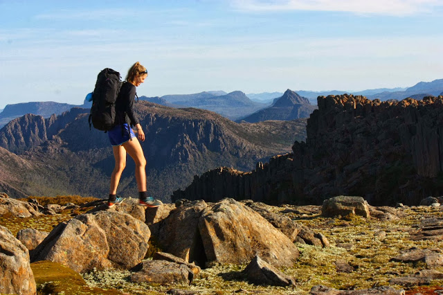
The packs were heavy with three days’ winter gear, just in case it was cold up there. My boots were unfortunately still wet from the Walled Mountain trip (only one day separates these two trips). My socks were wet before the first official step, and stayed wet until the end.

With happy stomachs full of pineapple-and-walnut cake, we launched into the wonderful rainforest of the “Pillinger trail”, eventually arriving at a wonderful open plains section, replete with tarns, a mighty view of Pillinger and a clear stream for our first break after nearly an hour. Already, we needed my homemade muesli bars.

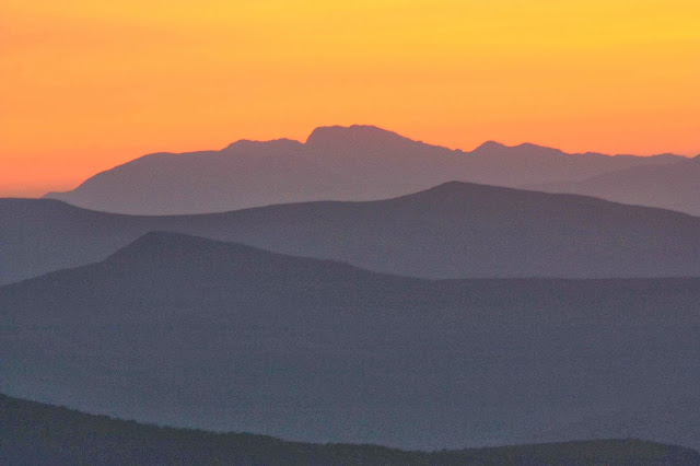
The second stop we had was well before the next hour was up, but we had now joined the Arm River track, and had reached its high point, with a vista opening up that revealed not only Mt Pillinger and the mountains of the Cathedral-Twin Spires collection, but also Falling Mountain, Mt Massif, Mt Ossa and more. It was wonderful, and required gazing at while we drank some more from the tarn before beginning our descent. Lunch was had in the river (yes, in. Elin had decided that leeches were not her favourite Tasmanian thing. We were running away from them by eating on the riverbed pebbles) just before we reached Pelion Hut.

The day was very warm indeed, the packs heavy, and the walk up to Pelion Gap even warmer. However, the wildflowers were so beautiful they filled the journey with joy (almost). The snowflake petals of bauera overlapped the trail, making it a tiny ribbon of root-striated brown through a snowstorm of dotted white, with the buttercup yellow of pultanea daphnoides and the red of occasional waratahs giving colour contrast. And then you re-enter a patch of cool, mossy rainforest for a different experience of pleasure. Unfortunately I had once run this in 34 minutes, and walked it as part of the Overland trail in bygone days in 43 mins, so had never thought of this stretch as anything other than a quick dash. The slow trudge of 2013 seemed to last forever due to these false expectations, and  the 1 hr 11 it took lasted in my mind a lot longer than that. We were hot and bothered.

The gap was beautiful, although I was bitterly disappointed that the scoparia bushes were not quite in bloom. I wanted to come back in a week. The mountain views made up for it. After another food break, and a chance for my husband to gather a bit more energy, we were off.

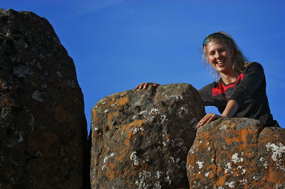
Miraculously, as we climbed higher, the scoparia gained in colour. Meanwhile, more mountains came into view. I was floating on a cloud of joy. I was also in paparazzi mode by now. I left the other two to go on ahead while I played at photographing. It was nice to drop back and have the mountain to myself.

At one stage I was walking along in a happy dream, looking at the light, the colours and shapes and singing away, and I was awoken from this traumverloren state by three chirpy voices saying hello – three former sudents here in the mountains, descending. How lovely to see so many young people out in the bush. With unis on holidays, there are lots of people with free time, but it is fantastic to see that it is used to get out into the wilderness. Bushwalking is NOT a dying sport, and if you think it is, just get out there in December. The hills are alive with the sounds of students … and young families for that matter. We met a five-year old peak bagger on the way out (already collecting points) who wants the Abels book for Christmas!

I had caught Bruce again before the serious climbing began, which is good, as I wanted to help him through it. Life is tricky if you have Parkinson’s disease and a wife who loves to sleep on mountains. Some of the manoeuvres near the top of the very steep section were challenging for me with a heavy pack, let alone him. We got there. We’d cope with the problems of descent tomorrow. Elin was waiting at the top of the steep part, and we all did the final short climb to where the view opens up together. WOW. A hundred times WOW.
 

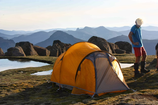
I was totally filled with emotion at the sight of the view that greeted us once we emerged on the plateau at the top. I couldn’t believe that it had all come together and that my dream of sleeping on top of Mt Ossa with a view like this was really going to materialise. Tears came to my eyes as I gazed out at infinty – a limitless vastness of space and shapely peaks, all different shades of blue in the late afternoon light. It had taken us 6 hours and 2 mins of walking to get here. (I had had no idea how long we might need, given my husband’s condition, or even if we really would make it. I never envisaged that the elusive view could be so marvellous.)

The remainder of the day was filled with peak staring, photographing, summitting, more peak staring and eating. Sunset and moonrise, it goes without saying, were a joy. We didn’t want to go to bed. We certainly didn’t want to waste such beauty sleeping. Elin resolved to stay up all night, just taking it all in. I settled for a slightly more conservative compromise of going to ‘bed’, but leaving all tent flaps open so that the view was not impeded and so I could lie in bed and gaze at beauty all night. The wind picked up after we’d turned in, so it was rather a noisy night, but who cares!

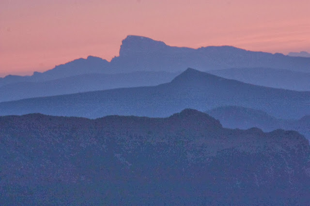
We all got up at 4.45 to see pre-dawn and sunrise itself, the other two perched on the leeward side of a rock; me right out in the open for the best photo opportunities. More WOW.

We all felt so very complete and happy as we tried to pack up the tents without having them blow off the moutain as we folded them, and reluctantly began our descent. We passed all three packs down at one point so as to climb unhindered by weight. The rest was no problem.

The rest of the journey we floated on a cloud of happy reverie, replaying in our minds the splendour of the time on top.

 I had ostensibly done Elin a favour, but it had bounced back as one of the most marvellous gifts I have ever had.

We also dashed up Pelion East (literally, as it was packless and thus very fast) en route home, but that will be a separate entry in the blog. All up, with two three-day trips in a week, we put in twenty-five and a half hours’ walking to which must be added lunch stops, choky stops, photography and more. My legs didn’t feel too flash trying to run today :-).


Abbotts Lookout 2013 Dec

Abbotts Lookout

Mts Anne, Eliza, Lot. Sarah Jane (from R to L)

I was very disappointed to discover that our group had not obtained a key to drive up the road to Abbotts Lookout, which would have then given us time to also summit Marriotts. Instead, it was announced that we would walk up the road to the first, and not have time for the second. Road walking is not really one of this bushwalker’s favourite activities. I’m a BUSHwalker, not just a walker. Oh well.

Looking west to the Thumbs

 The negatives of thwarted expectations and hopes (and one less summit) out of the way, I have to say that if you’re going to walk on a road, this is the one to choose, as all traffic is prohibited, and it could not be lusher or greener if you paid someone to water it daily (that’s already been taken care of). The real test – would I do it again? – has the answer, “most definitely yes”, and would do it again even next week if the opportunity arose.


The trip up, I really enjoyed as I do love exercise per se, and whilst strolling drives me crazy with impatience, being let off the chain and allowed to meet at the top gave me licence to just enjoy going at my own pace. Had I not been lugging a couple of kilos of camera gear plus warm clothes for the top, plus our lunch, I would have run, but at least I was not required to slam on the brakes or wait for long stretches as we went up the road, so that made it a pleasant outing.
At the top, if you could ignore the “Tourist Award Winning” structure, which today, like almost every other day, had not one single tourist (they paying about $100 to be driven up the same road and let inside the building), the view was monstrously fabulous. What a shame they don’t man their white elephant. We would have all very happily bought coffee and cake from the machine we could see on the bench inside. As it was, we sat on the verandah and alternately took a few more shots of the stupendous view and ate our lunch. Several members of the group took just over two hours to get up the mountain, and nearly as long to get down, so it ended up a full day’s activity. 

Telopea truncata

On the way down, I had a lovely time dreaming, singing aloud as no one was with me to get disturbed or annoyed, and gazing at the scenery. Up the top, where it was higher and dryer, with stunted vegetation (mostly dwarfed eucalyptus coccifera with a scrubby understory) and far more visibility, the road headed straight for Mt Anne. I walked along, my attention captured by one of the best views of her I can remember, while to my right was an eternity of white bauera that looked like a snow storm with so many tiny white petals, light as snow flakes. Walking gave me time to fully digest this mass of delicacy. The greens of cutting grass made a marvellous contrast to the otherwise olive colours on offer. Bright yellow pultenaea juniperina stood out amongst the green with white dots, as did the brilliant red of numerous telopea truncata. Naturally, I stopped a few times to photograph. Soon enough I reached a corner where direction and altitude changed, and first I encountered a wonderful myrtle forest, and after that the forest became more truly rainforest. It seemed like the variety of ferns was endless, each one with a slightly different shade of green, but all greens being the lime-spring green that always lifts my spirits. The fronds shook in the wind that had changed from raging on the higher slopes to a more pleasing breeze once in the protection of the bigger trees. The moss seemed as if it were at least ten centimetres thick – fresh and wonderful – and it spread sidewards to cover everything but the piece of road used for the few vehicles that are permitted that way.
So, whilst it seems silly to walk on a road when driving is possible (allowing time for the real bush), I do have to say that I enjoyed this little exercise, had a great workout, and the scenery was utterly wonderful. Given no time constraints, I would opt to walk rather than drive even if someone did give me a key. This is definitely a family-friendly walk.
To reach the start, take the Styx Road, shortly after Maydena, cutting under the main road. Roberts Road, which you walk up, is left off Styx Road. Park at the locked gate, and walk upwards to the top. The actual summit is a mound of rock on the right, just before you reach the building. The building, although a blot on the landscape, at least serves the function of providing a dry verandah and wind shelter for having lunch, if needed.