Parangana Sugar Loaf 2017 Jun

Parangana Sugar Loaf Jun 2017


Parangana Sugar Loaf is to the right. One has to cross the water first.


Parangana ummit cairn (not quite on the highest point, but it will do).
When my friend Maureen told me she was leading a club trip to climb a mountain that you had to get to by boat (Parangana Sugar Loaf), I begged her to add my name to the list. I then had to go off and look up the name of this mountain, and to find out where on earth I was actually going. I love mountains that you have to reach by boat, so didn’t care about its location. It was handy to discover that I wouldn’t have to drive too far – and hour and a half did the trick.


I love the way that the peak baggers’ list gets us out to experience parts of our state that we didn’t even know existed: we explore new mountains, whole new areas, drive down previously unexplored roads to get there … the whole package enriches our lives. On this occasion, I got to meet some new, interesting people, too, as our common purpose brought us together to get over the water and climb this new peak.


It was only a little adventure, but we spun out the expedition for long enough to have the obligatory lunch up where the best view was. Although it is now officially winter, and despite the fact that there was a frost in the morning, you can see from the pictures it was a glorious day. The water was not tempting for swimming.


Afterwards, I used my proximity to the Arm Falls to go off and explore them (natureloverswalks.com/arm-falls). The others headed off to the North West, from whence they’d come. NWWC is a great club. Nice of them to let me gatecrash their walk.
I left my gps in the car. When my friends give me a route of our climb, I’ll publish it here.

Stitt Falls 2017 May

Stitt Falls. May 2017


Silly google hasn’t heard of Stitt Falls, but then, it seems to know very little about the secret treasures of Tasmania. It changed Stitt to State, just as it tried to change Wandle Falls to Handle Falls, and many mountains to some American name that better suits it. Perhaps in the case of Stitt Falls there could be some small justification, however, as I, a Taswegian, had never heard of them either until a couple of weeks ago, and yet I have visited Rosebery and nearby Tullah on numerous occasions, if for no better reason than to buy hamburgers or hot chocolate before or after a climb of one of the many fabulous mountains in the region.


Recently, we passed through Rosebery for a “nature stop” and saw outside the noble toilet block, a picture of the local Stitt Falls. We were in a rush to meet friends to climb Mt Zeehan at the time, so couldn’t stop, but I stored the information for another day: namely, last weekend, when an opportunity came our way to check the falls out. The information seemed to indicate they would be reached by using a park called Stitt Park as the starting point, so we went there to find another toilet block (maybe the hamburgers in Rosebery are not as good as they might be), but no falls. At least we could ascertain from the map there that we needed to go in the direction of the camping area.


This was not what I would call a bushwalk. Once we’d found where to park the car, we had to walk all of twenty seconds to see the falls. I loved them. I enjoyed the rich colour and texture of the rocks that the water had to weave around before it dropped, and I really enjoyed the huge drop to waters way down below me. I desperately wanted to go down there, but not without seeing if there was a tried and successful way. The bottom just begged me to come and explore. I have no idea at all why Rosebery doesn’t do more to attract people to these lovely falls. How much trouble would it be to have a taped route to the bottom? That said, I would much prefer the nothing that is there to a wretched tourist 1.5 meter-wide path, sealed and smoothed out with huge railings so we can’t see over that seems to be the norm these days. Sigh. Maybe next time I can go to the base. It looked so appealing down there. Off we set for Waratah and the Wandle Falls instead.
For them, see www.natureloverswalks.com/wandle-falls/

Pyramid Mountain 2017 May

Pyramid Mountain 14-16 May 2017.
(For Day one of this three-day hike, see natureloverswalks.com/Rocky-Hill/).


Summit day for climbing Pyramid Mountain dawned. A light fog surrounded us; the grass, of course, was icy, as were our tents. The sun was a kind of dispersed yellow glow to the east. Mountains like High Dome, Pyramid and Goulds Sugarloaf were beautiful silhouettes as we ate breakfast and prepared ourselves for our adventure. How would things play out? Could we do this in a day at this time of year?


We set a turnaround time of 12.30, given the now early time of sunset, which didn’t give us much room for hold-ups or errors should we land in highly-resistant scrub. Off we set, both curious and hopeful.


We were at “hill 1173” within 45 minutes; passing Mediation Hill in another 45; and topping the next hill after leaving the main Eldon Range route (Hill 1129) in a further 25 minutes. Things were going well so far. Pyramid looked pretty close by now, and we’d not quite been going two hours. And then the rot set in. After this hill that was a bit of a bulldog in lamb’s clothing, came a route that went first SE and then swung along a ridge that looked fine from a distance, but was like a duplicitous politician at close quarters: deceitful, barbing, and best avoided. Trouble is, we needed to traverse it all the way along its mean and nasty length until it started climbing to the next hill that was so uninspiring it didn’t even have a name or a height number. At least we didn’t need to go all the way to the top of this one, as there was a saving patch of rainforest if you contoured around to the next saddle, the (whew) last saddle before the bitch of a climb up Pyramid.


“I thought you liked climbing, Louise!” you say. Yes, you’re right. I love it, but not when the climb is in thick, dense, impenetrable, energy-sapping, defeating scrub, where you work and work and then look at a your map and realise you haven’t even covered a hundred horizontal metres and you can’t see the mountain, and you can’t even see a way of going forwards. You try left and right and retreat a bit, telling yourself retreat is often the best way to advance … but when you retreat all the way back to the start triangle it isn’t (well, bit of hyperbole there). After what seemed ages, we came to a spot where we could glimpse something. Ahead lay a gulch. Beyond that, cliffs and more bushy climb. We decided we needed to drop down and get on the spur above the cliffs. Somehow that went quite well (face-in-the-dirt steep), which is good as I was becoming increasingly despondent, fearing we’d come all this way to be locked out of the summit at the last minute. Once we were above those cliffs, we could see paths of erosion ahead that would lead us the rest of the small distance to the top without any hindrance other than good old gravity, and who cares about it? Not I. Well, not normally. I was feeling tired and hungry by this stage. One hour after leaving the saddle (a distressingly small distance below us), we were standing on the summit. I didn’t stand for long. It was 11.30 and I wanted lunch. NOW.


The return was faster, much faster. From above, a better line was easier to find, and what took us an hour up, only took thirty-three minutes down (and not just because down is faster than up). The ridge didn’t seem quite so inhospitable now we were in a buoyant mood, and we had a much better route from it to the summit of hill 1129. It was so great to curve around the summit of Mediation Hill and know that our bushbashing for the day was over. We just had to follow the ridge back to our waiting tents. There was no way we would not be there before dark. We even had time to have a drink or two and photograph the dramatic cliffs below our camp. Drinking was unpleasant, as the water was so cold it hurt.


It was a freezing night. Temperature-wise, it was by no means the coldest night I’ve had in a tent (it was probably about minus four; I’ve experienced minus ten and worse), and yet I swear this night holds my personal record for condensation. My sleeping bag became saturated, and ineffectual along with it. Everything got wet. I suspect it might have been because my utterly drenched socks (wrung out, but there was still a large amount of water left in) were inside the tent, along with my somewhat damp coat and long pants. These things were inside, as they might have turned to ice if left in the vestibule. I feared my boots would freeze, but only the laces did.


In the morning, the ice layer on the tent was a thick and heavy sheet that I had to prise off using my tent peg, it being the only implement I could think of that could do the job. Normally my ice is in cute white crystals. I took ages to pack up in the morning, probably because I was dreading the moment when I would have to put those frozen socks back on, and the pants and coat that were still damp from the moist bushes the previous day. There was no point in putting dry socks in sodden boots, and carrying wet, heavy ones in the pack. It had to be done, but was not a pleasure.


We stopped at “Stu-slept-here” Hill (1111) for a drink, but, as with other days, drinking hurt. By the time we reached the glorious rainforest section of Pigeon House Hill, we knew we would easily make it to the car in the light – it was not yet mid-afternoon, so we relaxed and started to examine and photograph darling fungi on the way along that section. They were there in their hundreds, so many delicate beauties.


I made sure the camera and phone were well sealed before the final river crossing. At least if I landed in the drink so close to the car I’d be freezing, but would not hurt my electronic gear or get hypothermia. The world was good. We’d done it.


crepidotus sp


Mycena clarkeana I think


Please don’t be fooled by the dark lines there into thinking they denote a track: they’re depicting National Park boundaries. The boundaries, and our route, follow the ridgeline. Please also note that I refer to Hill 1173″. It is that height on the 1:25,000 map that we used for the greater detail. Oddly, the 1:100,000 map, used here for greater clarity, it is marked as 1120. I guess more modern methods have resulted in a height revision. Not sure.

Rocky Hill 2017 May

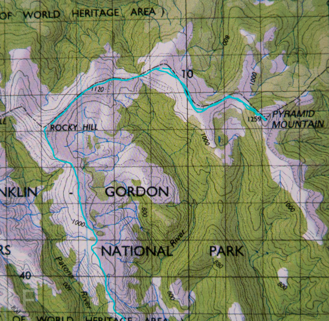
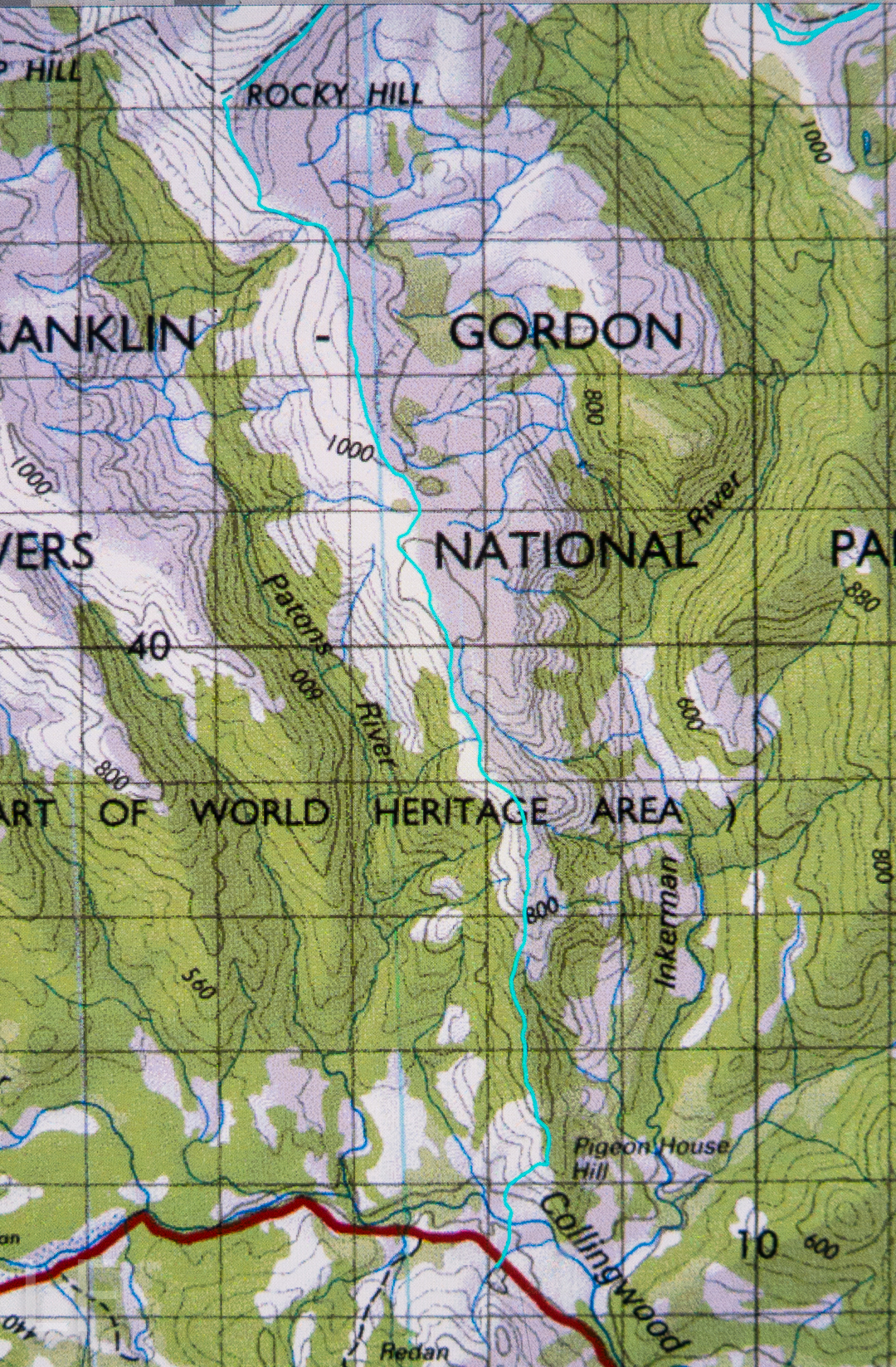
Rocky Hill 14-16 May 2017


We never doubted that we’d make it, but it was still an enormous relief to crest the final rise that led irrevocably to the summit of Rocky Hill. This was the second time the two of us had climbed Rocky, but was the first time we’d seen its rather elusive view. Clouds seem to enjoy Rocky Hill just as much as we do, and it pleases them to tease would-be view seekers.

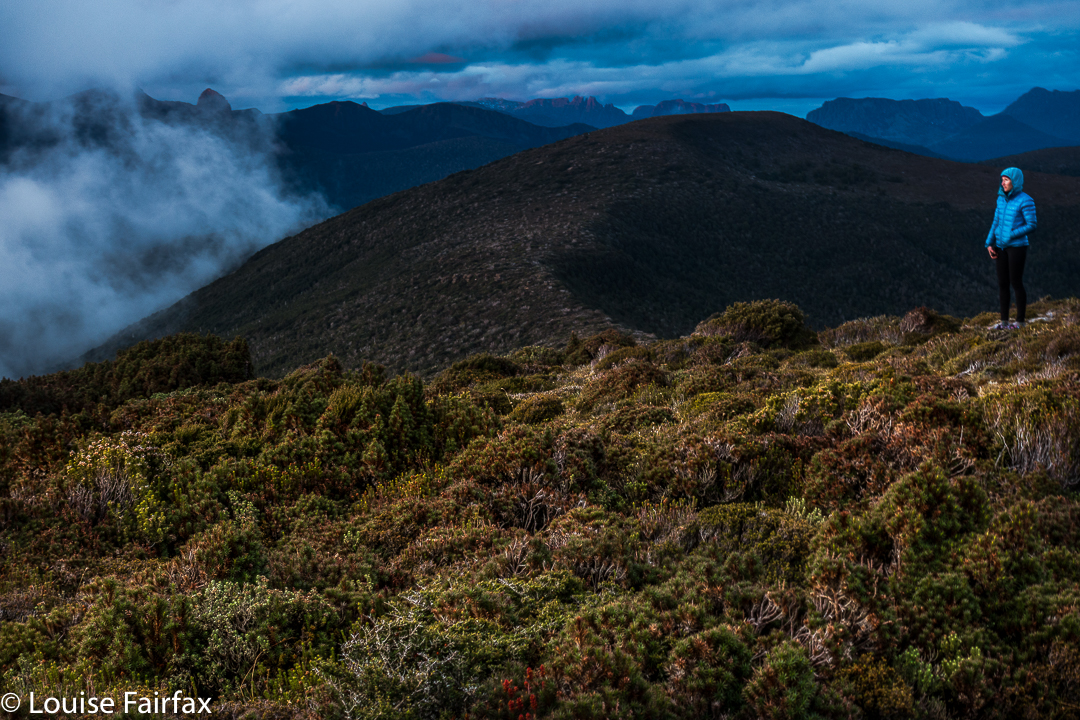
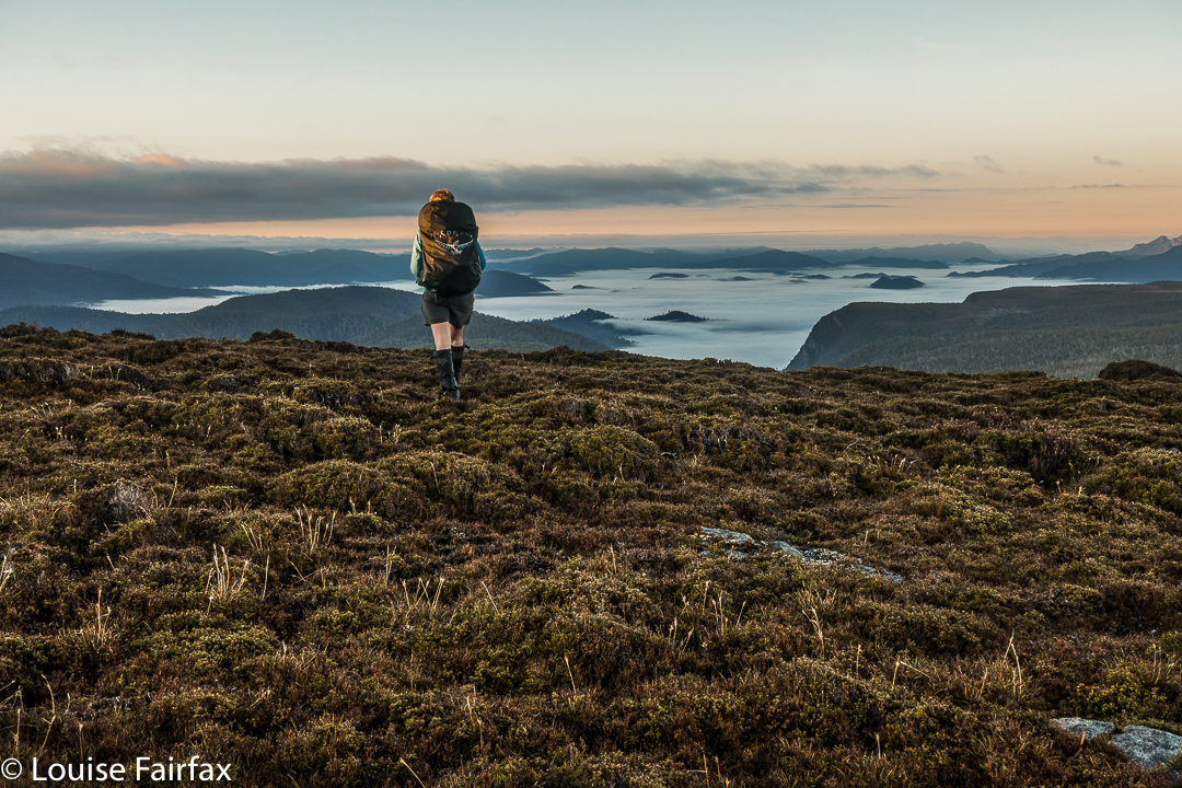
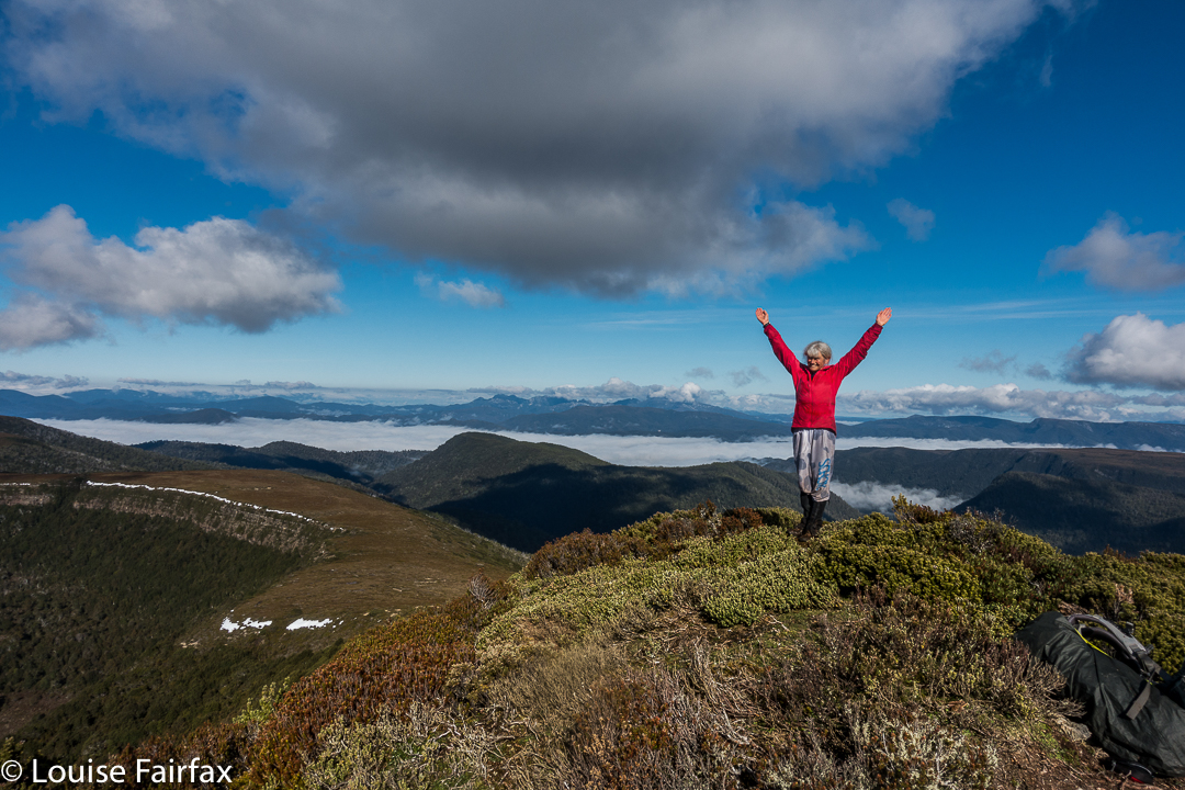
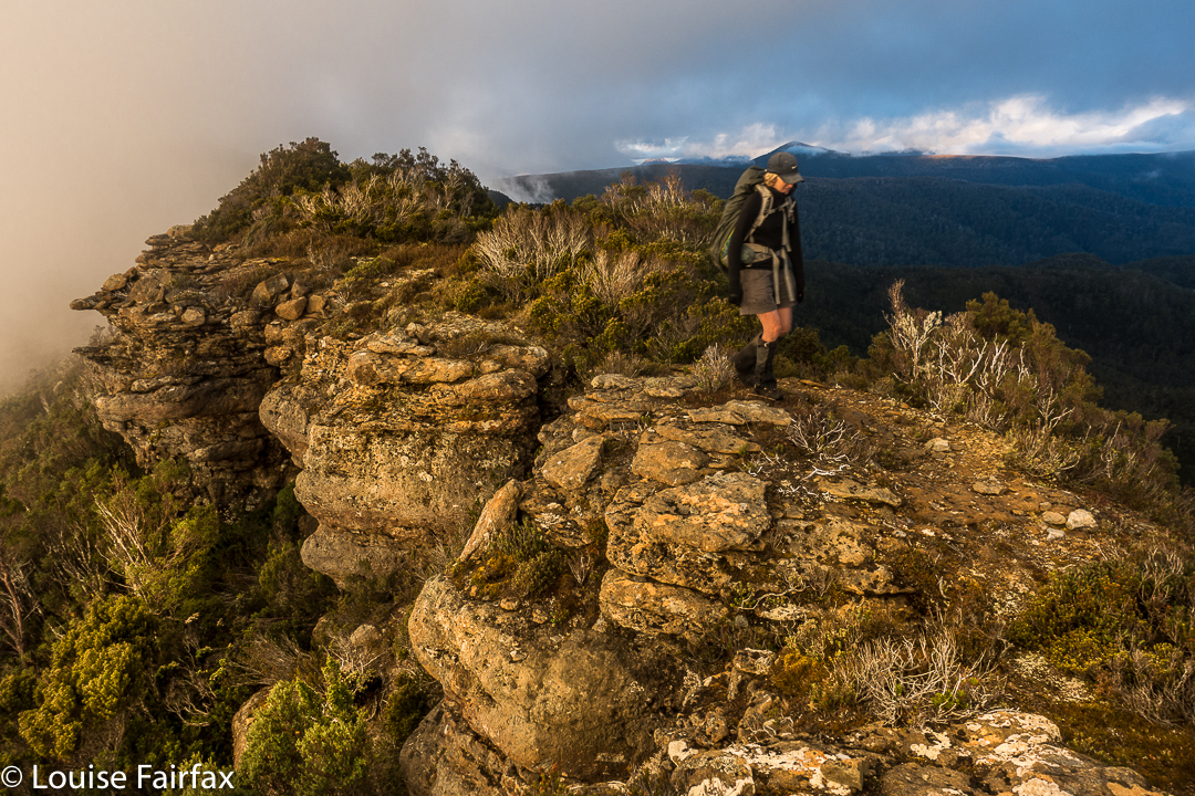
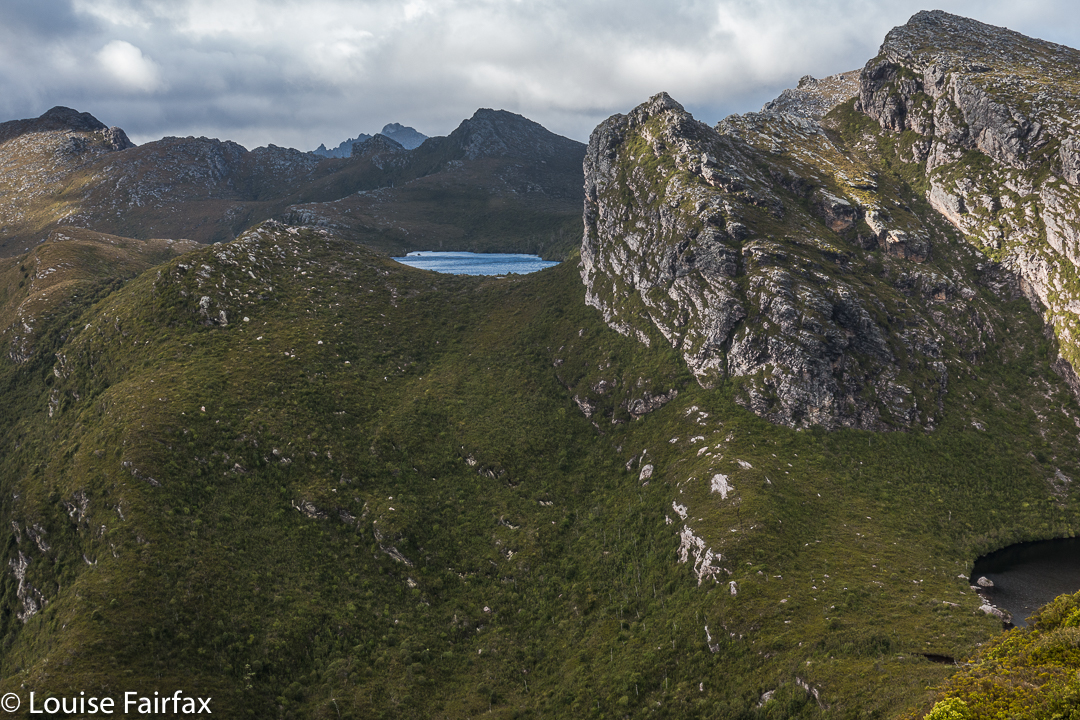
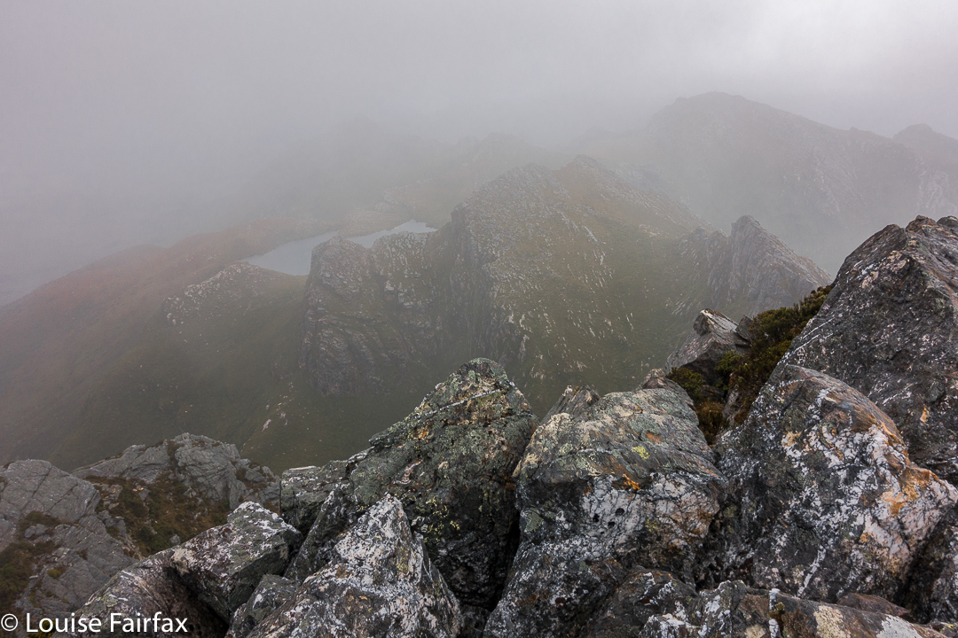
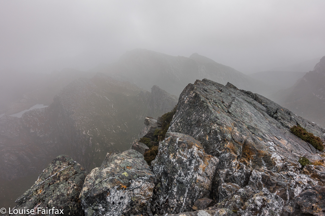
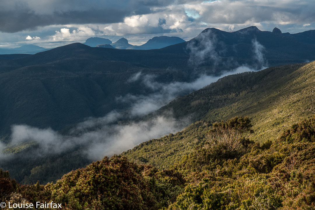
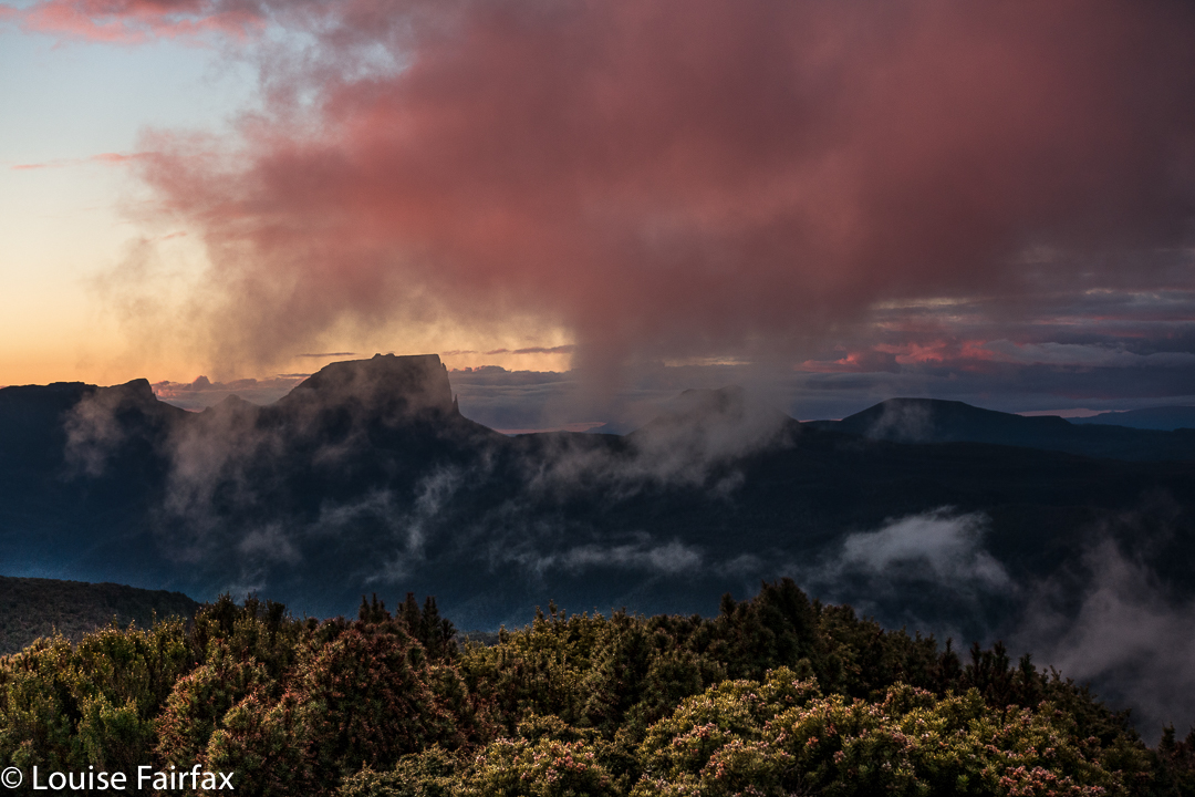
It was so worth the day’s effort to see what we were now seeing: viz, a vast array of magnificent mountain friends, almost all of which we’d climbed, although not all of which we could readily name from that angle. In particular, we adored the different perspective on Eldon Crag and Peak; it was also amazing to see the seemingly ubiquitous Frenchmans Cap, which must be the “most seen” mountain in Tasmania. Way to the north east, we could see as far as Cradle, Barn Bluff and Emmett, as well as Pelion West, Ossa, Thetis, Manfred, Cuvier, Byron, Geryon, Acropolis and Olympus – in fact, the bulk of the mountains that line the famous Overland Track. This was not a view that you just noticed and then departed from. You had to stay for a long time. We bounced around with delight, and stayed all night. Well, in fact, we stayed two nights, so good was the view. The fact that we’d arrived up there by 3 pm meant we certainly had time to progress further along the ridge as far as Mediation Hill, but we were in love with this spot, and we stayed put. We thought we could make it to Pyramid Mountain (our next day’s objective) and back from there, although it was a slight gamble given the short days at this time of year.


It being so delightfully early, we had the luxury of exploring our little demesne for the night, to suss out snow drifts as a source of water and hunt for the best yabby holes. We spent a whole hour just gathering water for the next two days so that if we got back in the dark the following day, we wouldn’t have to go searching for liquid in order to cook, but could collapse straight into our tents. Our fabulous grassy patch was just below the summit, but, unlike the summit, was soft and lush.


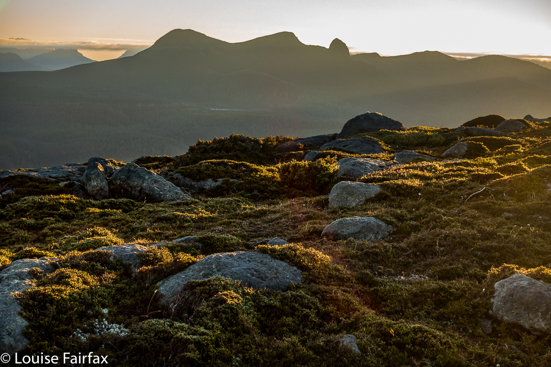
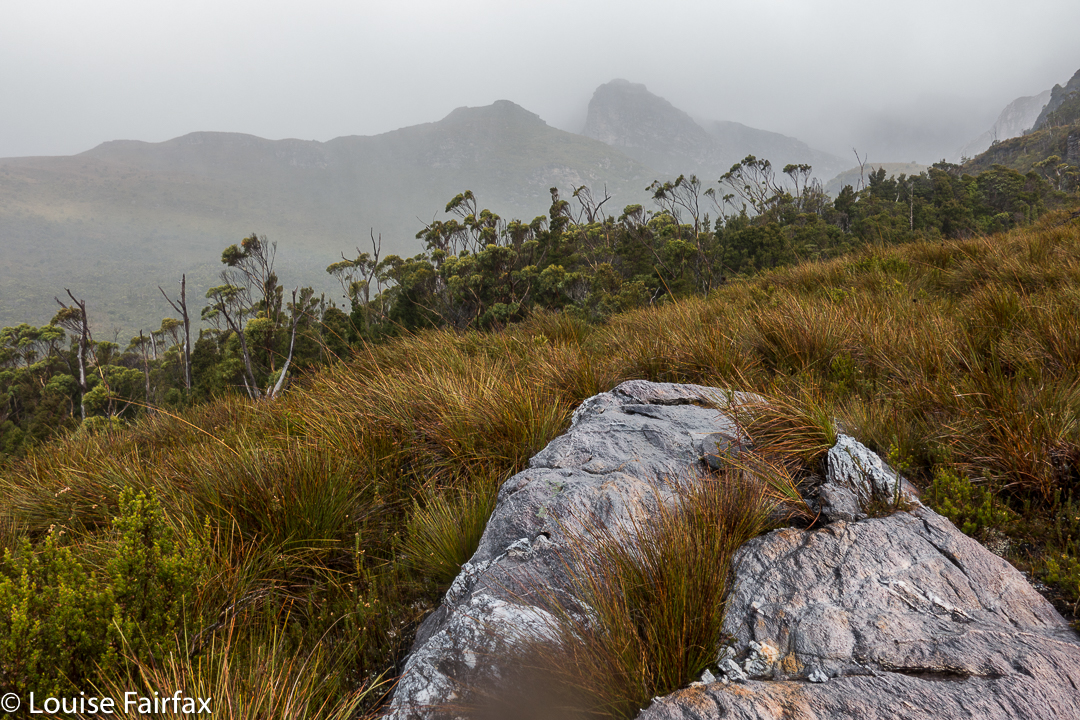
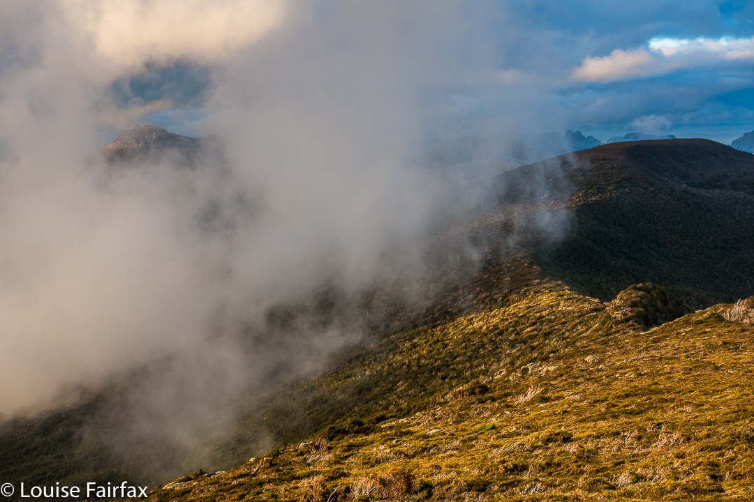
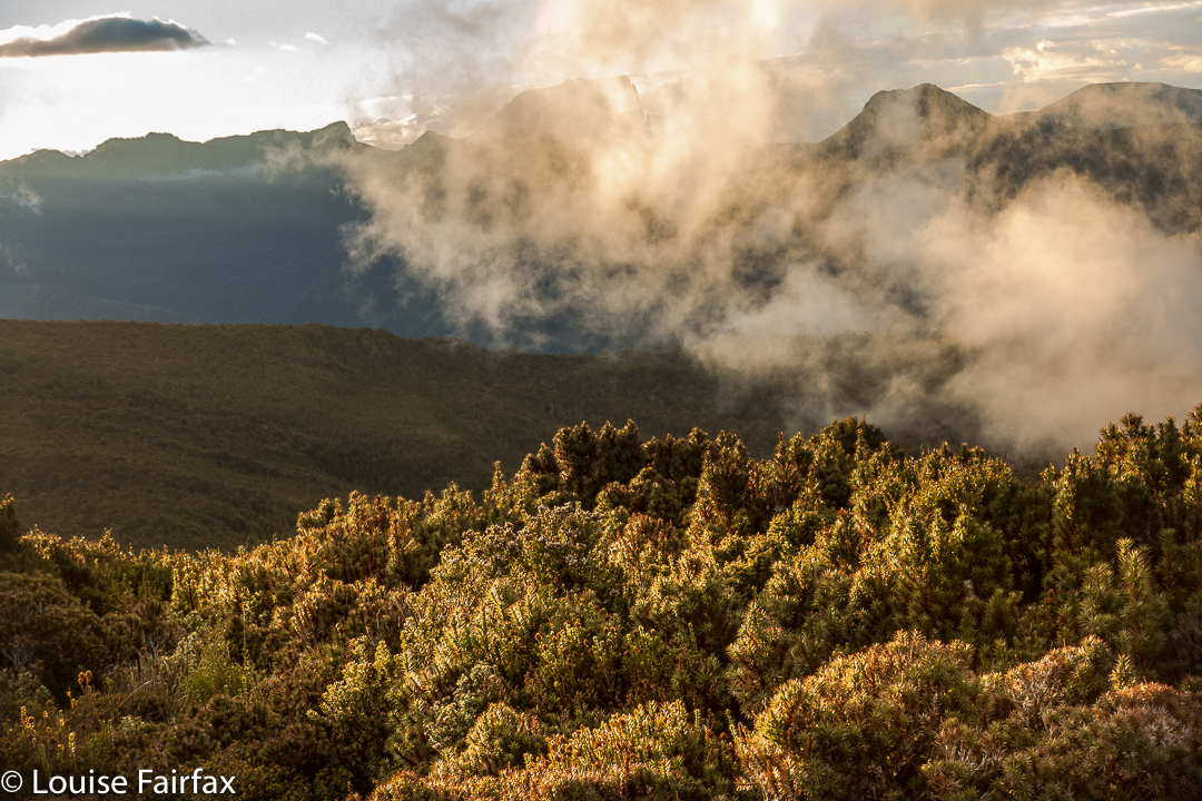
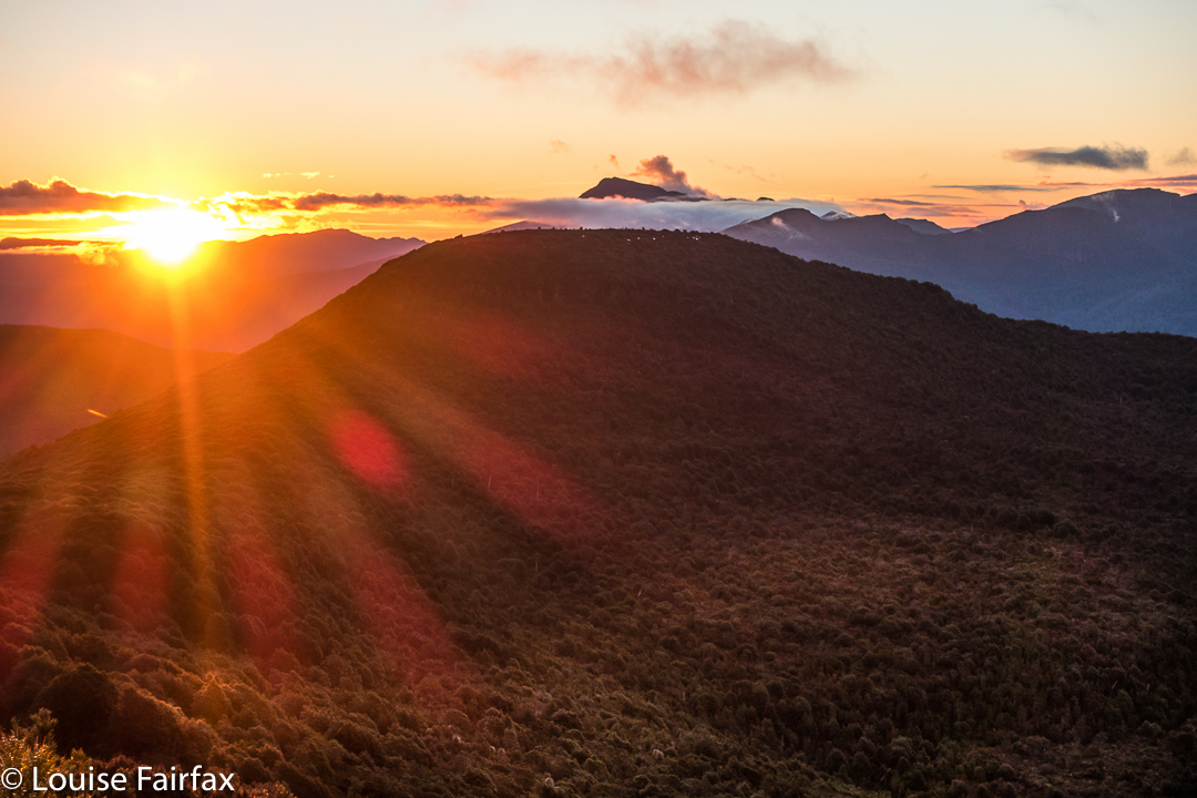
As we slowly pitched and did all the activities associated with turning our chosen bit of mountain real estate into “home”, the clouds rose up in drifts from the valley below, turning more and more golden as the hour advanced. They were soft, wispy clouds that only partly veiled the mountain silhouettes around. Right at the peak of the drama, the ones above turned quite a strong dusky pink; it was a beautiful scene that I will never forget.


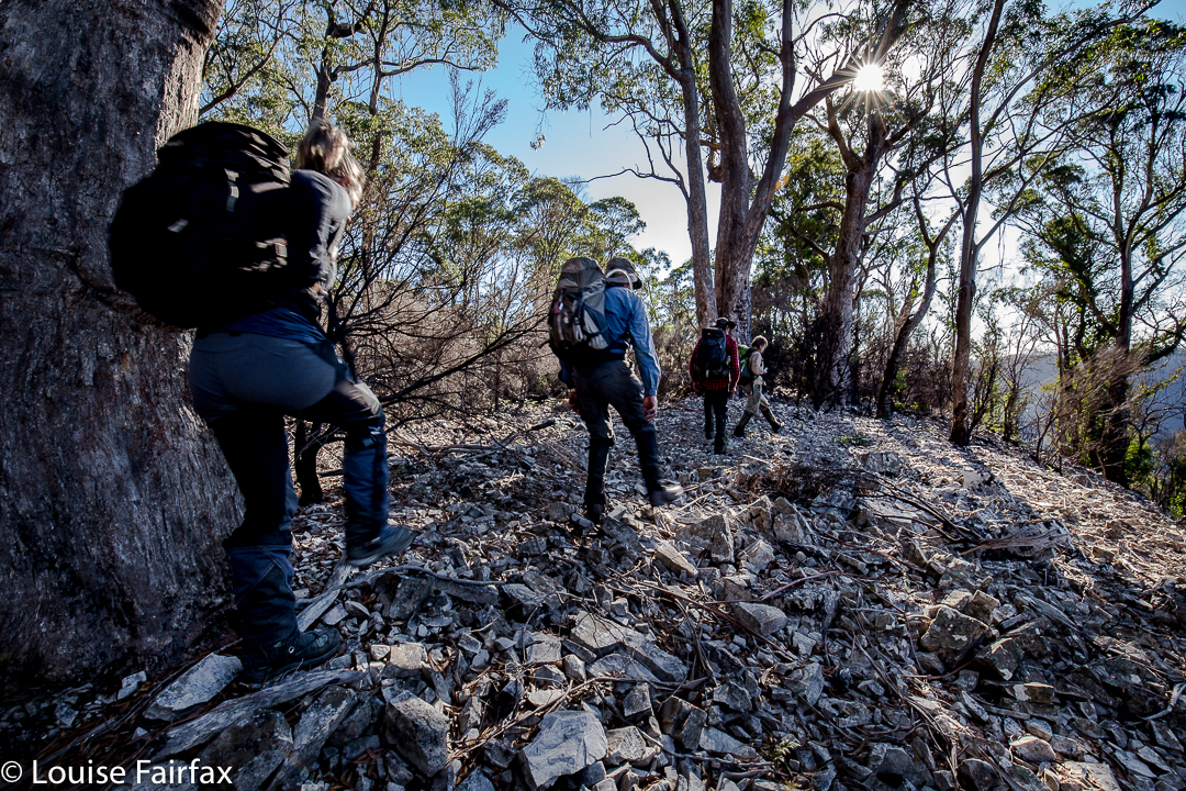
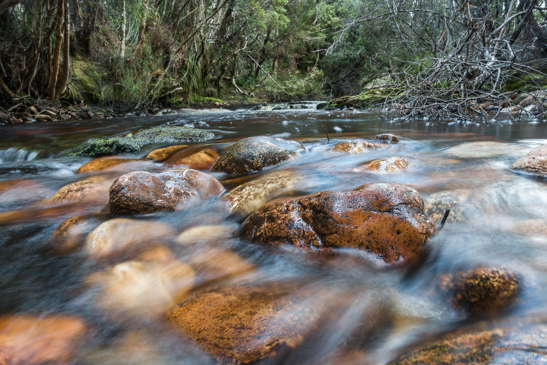
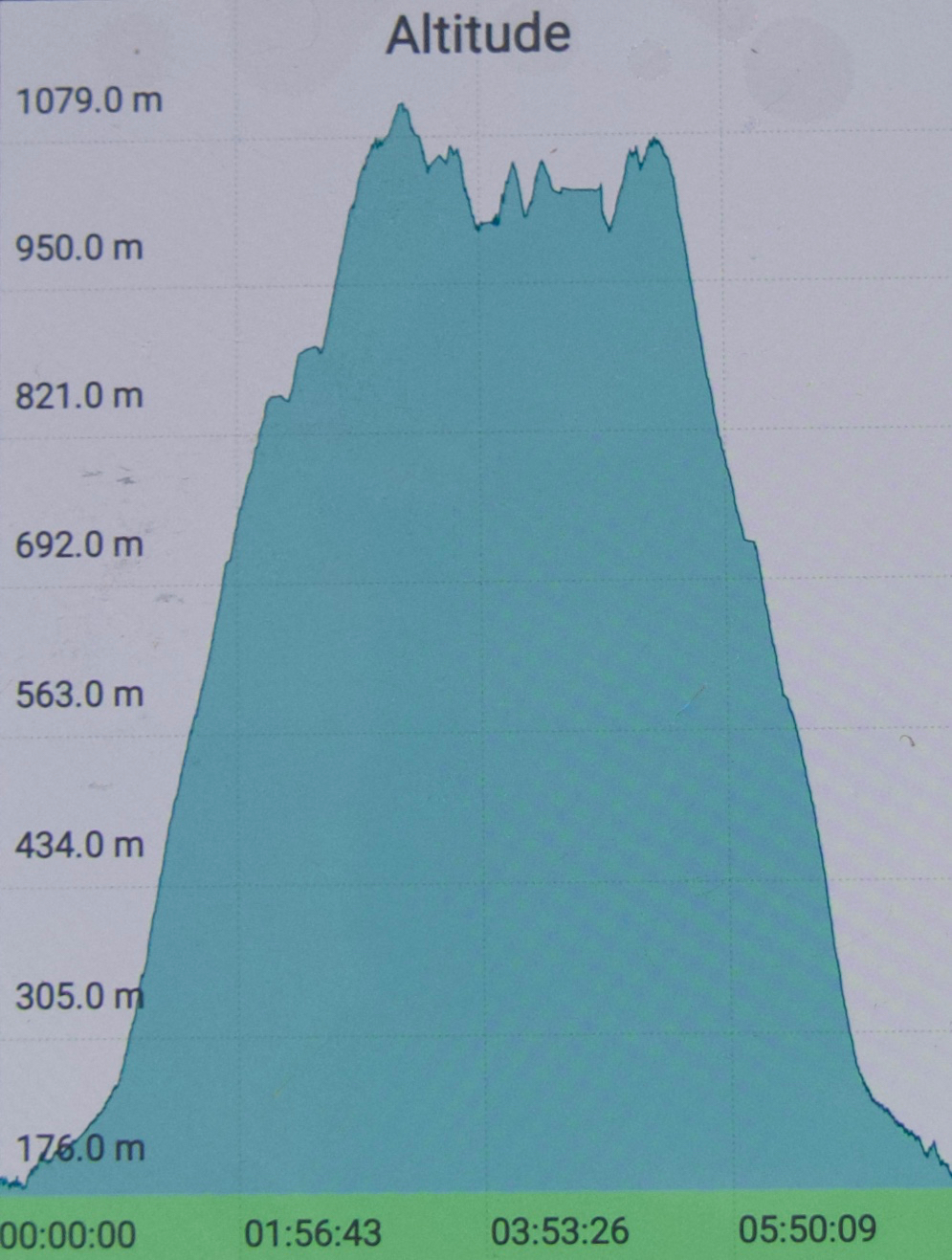
I don’t know why I had been so scared about crossing the Collingwood River at the start of the day. I guess I knew in advance that the temperature would be sub-zero, and that the river would not be summertime-low. It was, in fact, minus one, and upper-thigh high. Brrr. My main fear, of course, was slipping on the mossy rocks due to the force of the water, and falling in and getting hypothermic. I very sweetly let Angela go first to give me courage. It didn’t look easy as I watched her steadying herself, both arms out for balance. I grabbed a stick to help, took a huge gulp, and followed. I went in deeper than she did, mainly to keep on rocks that didn’t look as slippery. I made it, but my bottom half was frozen. Off we set up the very steep Pigeon House Hill. Surely that climb would warm us up. It warmed up everything but our feet; they took a little longer. By lunchtime they’d thawed, but, of course, they remained wet for all three days.


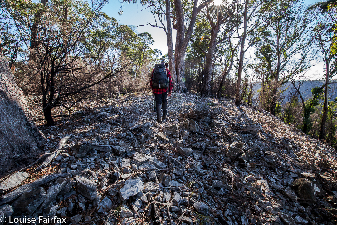
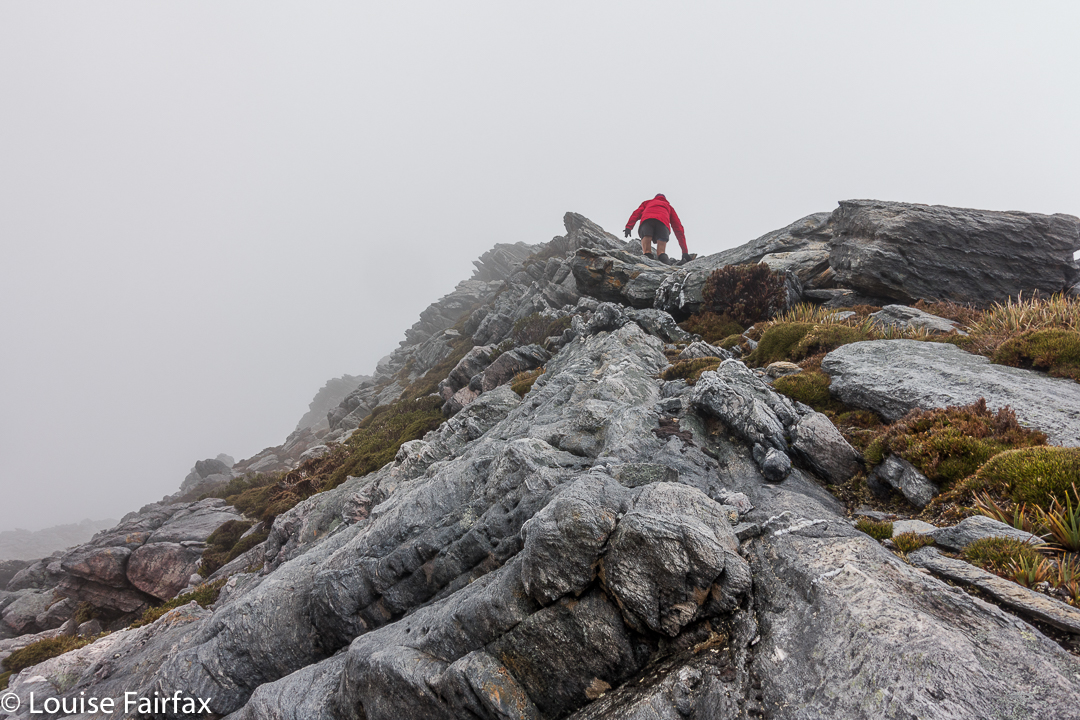
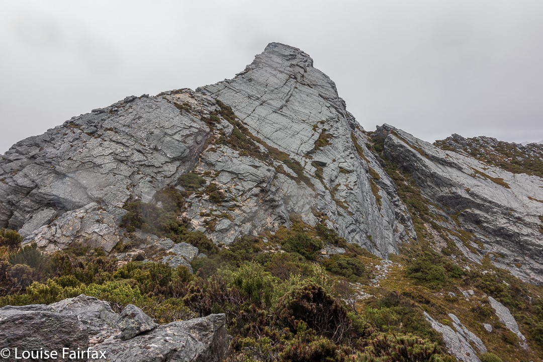
We found some random tapes on Pigeon House. We couldn’t work out where the person who put them there was going, but fortunately there weren’t too many. They took one onto the thickest part of the ridge, whereas the pad of least resistance, and the old route, skirts around the top at that early stage. We backtracked to find old cuts and used the old line instead. It was much easier going. If you are new to bushwalking, please don’t interpret that as “Oh goody, there’s a track up there. Let’s go.” Unfortunately, what I am referring to is small traces of where people have gone on some distant past occasion; you use broken or cut branches or other signs of humans passing (disturbed bark) to pick your line, and you have to have a very good idea of where you want to be going in order to gain from these signs. Please only venture into this untracked territory if you know what you’re doing and have a lot of experience. It is not for novices, or even for intermediate-standard walkers.


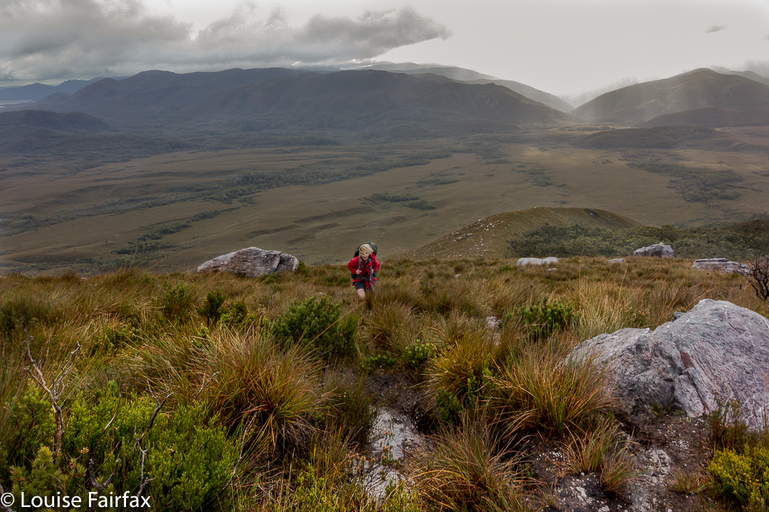
Once we gained the ridge past that early topping out, the going was easy for a little while, until our second “top out”, about an hour later, when we emerged from the beautiful forest onto a scrubby hill. From then on, for what seemed a long time, we had to lift our legs very high in a goose-step and at times force our way through higher patches of scrub: nothing too bad, but it does sap your energy anyway.


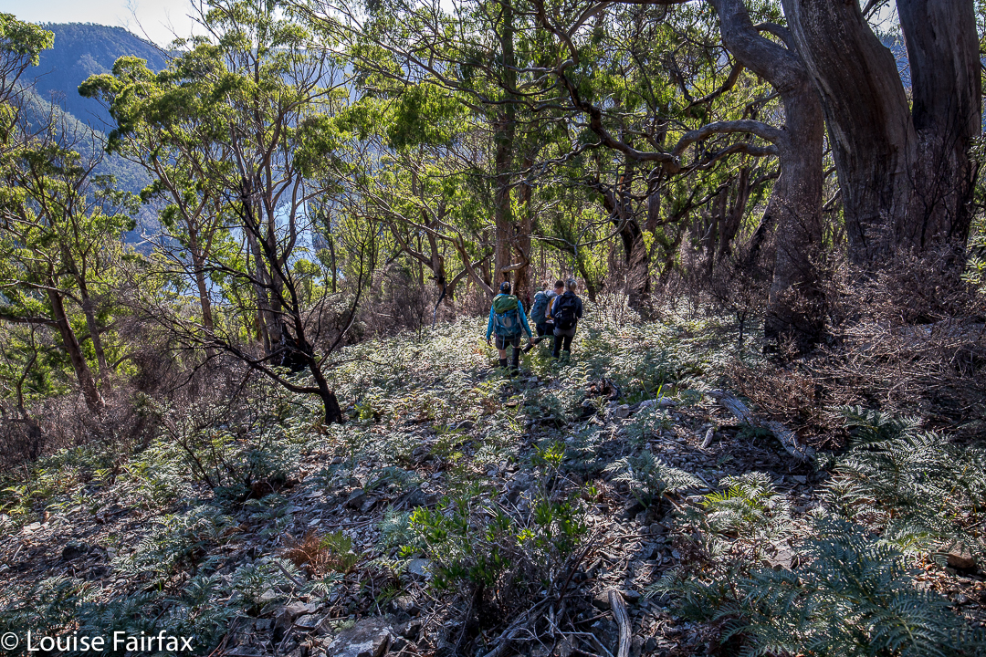
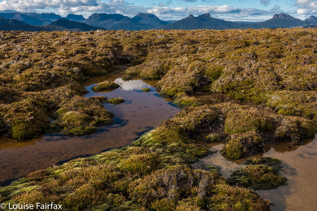
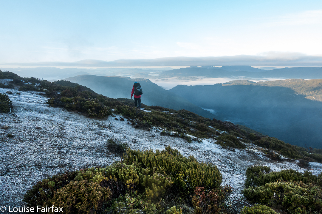
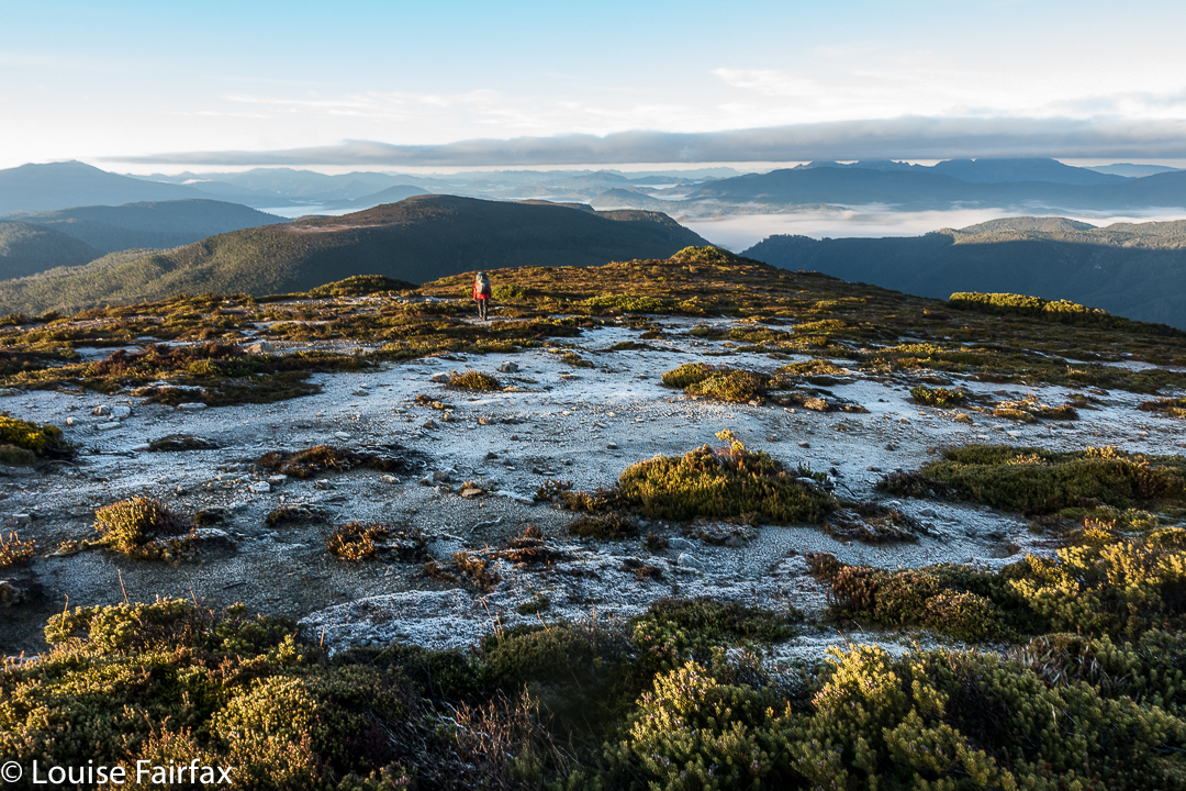
We concentrated on choosing a good line, and worked hard through the scrubby bits, and eventually we got there. If you don’t know Rocky Hill, don’t be fooled by its deceptive name. It is not a hill at all. It is an Abel, which means it is higher than 1100 ms (1194 to be exact), with a significant drop all around. Already snow drifts were building up with winter on the way. Some tarns were iced over. And the views, as said, were magic.


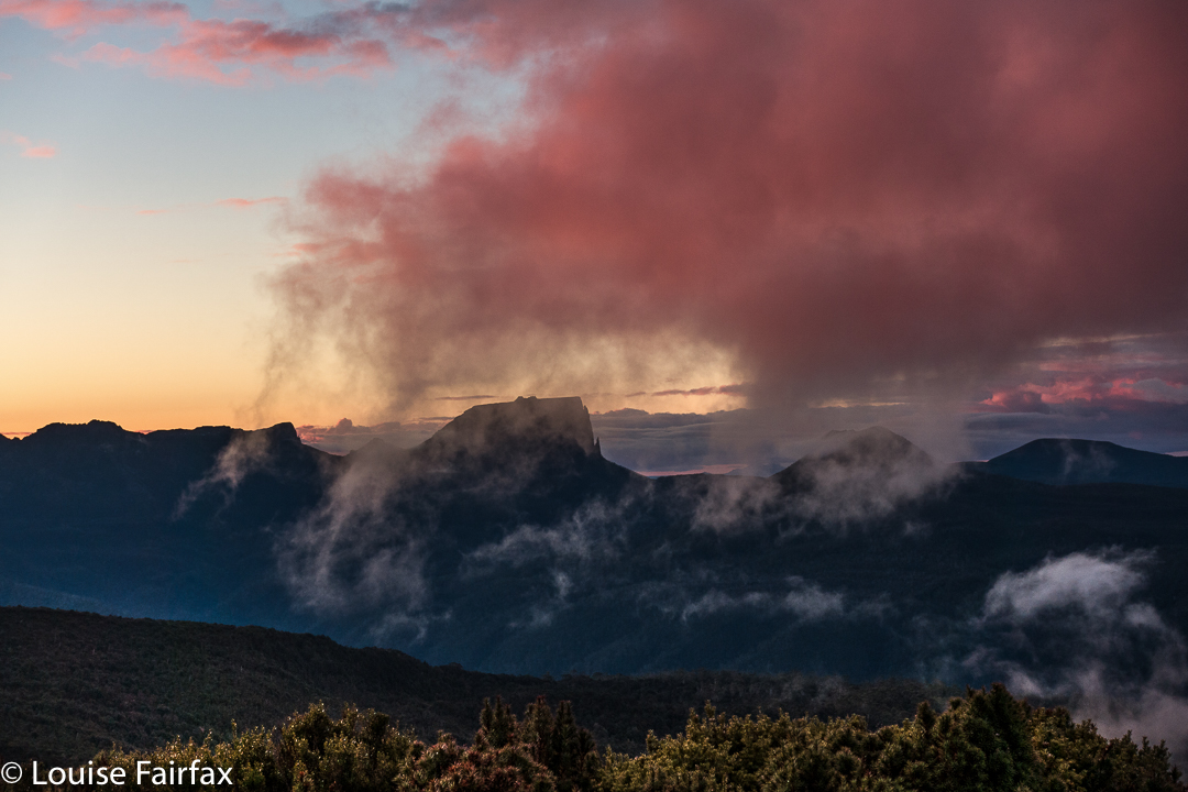
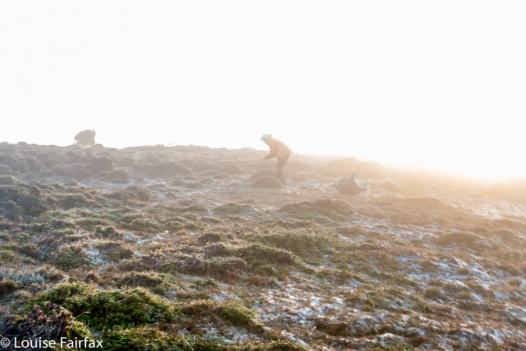
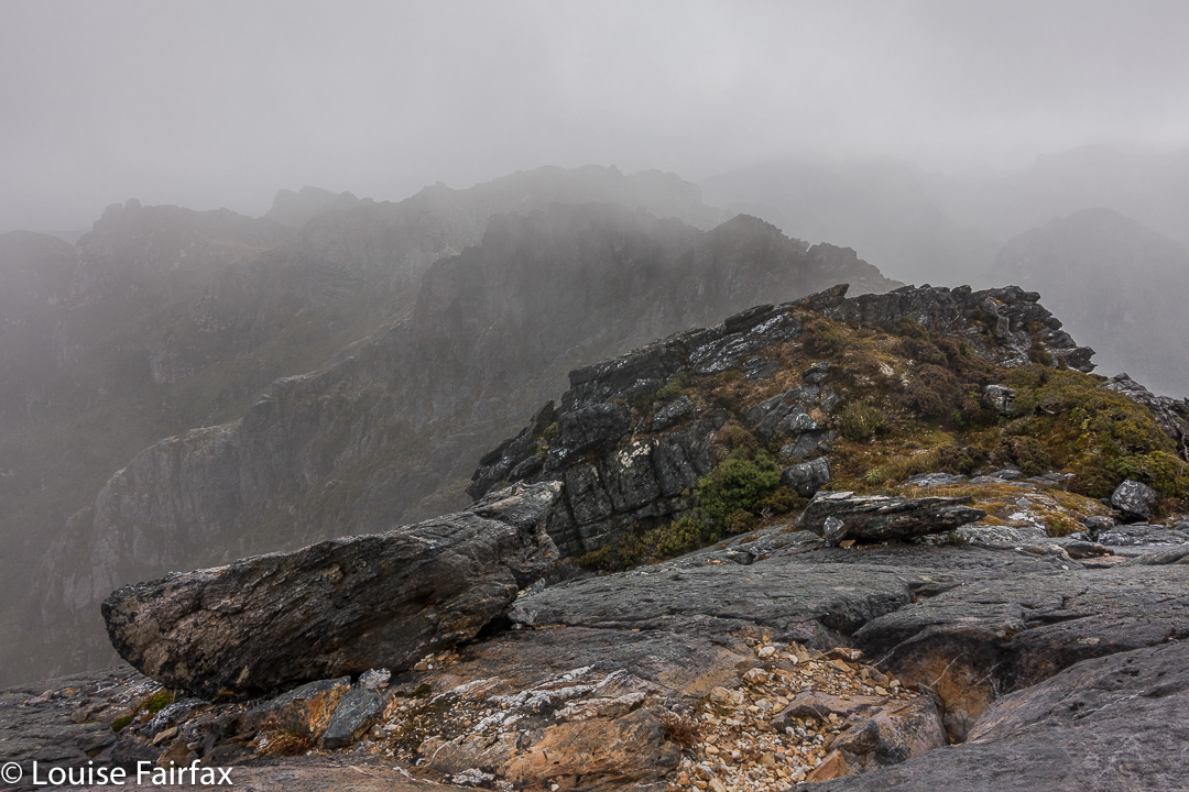
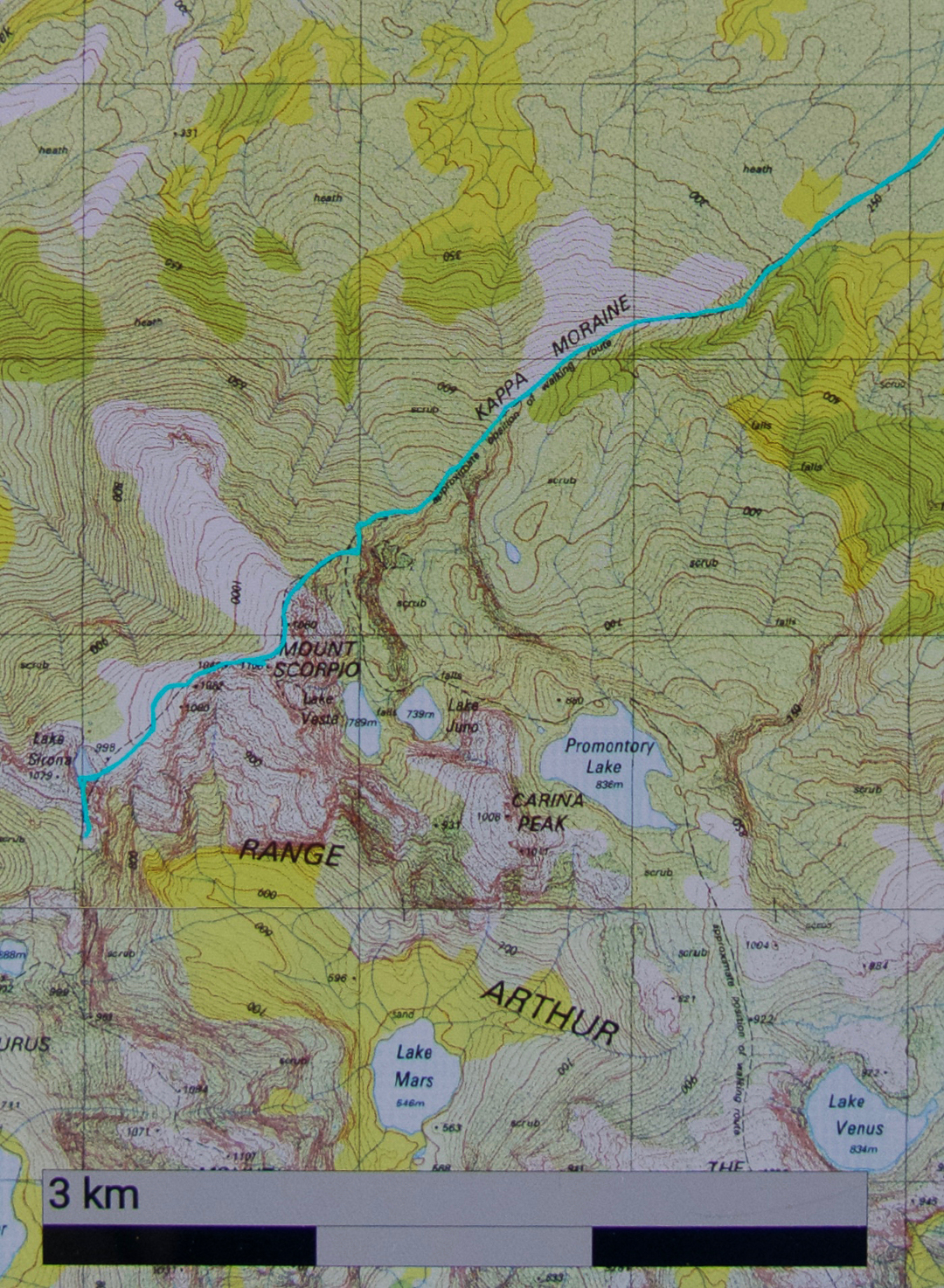
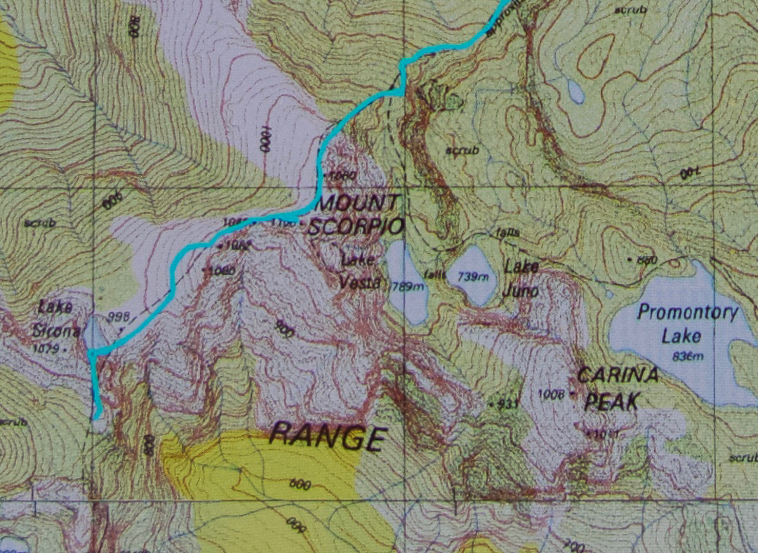
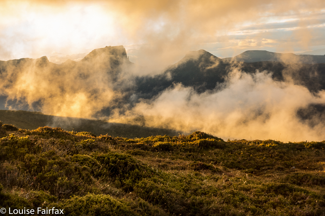
Next day, we’d climb Pyramid Mountain if all went well (and it did. See natureloverswalks.com/pyramid-mountain/). It was a big ask, so close to winter with the shortened days, but we’d give it a go. Just in case we weren’t quite as successful as we hoped, we packed bivvy bags, torches and a warm jacket beyond the many bundles of clothes we were already wearing. I thought that if we were stuck out overnight with wet gear, a bivvy and extra jacket would not be enough to save me, but I took them anyway. As it transpired, we were back well before our curfew, and had time to play on, and photograph, the rocks on the ridge with our tents in sight, as the mist once more rose up the valley.


Scorpio 2017 Apr

Mt Scorpio, Apr 2017

Our camping spot, Seven Mile Creek.
Mt Scorpio, stuck out there towards the eastern end of the Western Arthurs, has always had a certain allure. Perhaps it’s Dale Lisson’s photo in the Abels II book, with diminutive, rucksacked figures walking up a knife-edged slope, that gave birth to my feelings towards this mountain, and created a mixture of respect and fear, combined with a  desire to be on it myself one day, and to summit it via that edge.


Climbing Kappa Moraine.
At last I got my chance this Easter. Unfortunately, a different book said not to climb it in wind. Even more unfortunately, the weather whipped up a beauty of a blast, together with mist and rain, on summit day. Oh well. That’s nature. She doesn’t cede to our desires.
On our first day, we had walked in over 20 kms along the MacKay track to Seven Mile Creek. It was not necessary to walk all this way – there is a Kappa shortcut in existence – but we decided we wanted to camp there this time; we’d go up the shortcut on our second visit to the area (we both envisage many visits yet to come). We knew the forecast for summit day was not good, but Angela is a working woman, and sometimes you just have to take what you can get.


We both loved this glimpse of Promontory Lake before the clouds came in. I must go there one day!! And I must climb Carina Peak to its right.
We were quite hopeful as we walked across the plains from our tent site next day (about one hour’s duration). It was cloudy – a little bit misty – but that was all. At last we were climbing, not having a clue if one of the mountains we were looking at was our mountain, or just a kind of prelude to it. We only got glimpses. We could feel the wind increasing, so, short of the top, donned extra layers in case it got wild up there. Good move.


Angela climbing the final stretch.
The Abels book implies that you just kind of walk straight to the top, but when we reached the nearer end, we could see no obvious route up, and certainly not the one of the picture, so I voted that we go to the further end instead. THERE we found the scene I was awaiting. I didn’t want to completely copy Dale’s image, so chose a different angle and asked Angela to please go on so I could photograph her on the dramatic slope. The wind blew more strongly.


Summit “view”.
After she had finished posing for me, Angela ducked left, not enjoying the deadly drop down the cliffs to the east, and heeding the warning not to climb on the ridge on windy days. I followed up at this stage. I saw where she had gone, but was rather enjoying the airy space, and had plenty to hold on to, so kept on the blade. I got to the summit, photographed, wondered where Angela was, and began to descend, hearing her calling  me as I did so. The wind was so strong I couldn’t hear what she said, and neither did she hear my full answer.


When I got back to her pack, and saw she was not there, mild panic set in. (She didn’t want the wind buffeting her rucksack, possibly knocking her off balance, so took it off for the final climb. On the other hand, I wanted my back protected from the iciness of the blast, and thought that if I fell, I’d prefer to land on my pack rather than my bones. If you could see the drop, you would know that whichever part of your anatomy landed first would be utterly irrelevant, and that pack or no pack would be of no consequence at all. Be that as it may, my pack stayed on).


I was unbelievably relieved when I saw her emerging around the corner. Her yell had not been for help: it had been to tell me she’d found a cairned route up that was not exposed at all. She enjoyed her route. I liked the mild adrenalin rush of mine, as there was no real danger if you didn’t let go, and the handholds were firm.
All of those antics complete, it was now 10.30. We decided that, despite the weather, we’d continue on towards Aldebaran. However, with each step, it seemed, the rain got stronger and the wind more forceful. We had to cross a saddle before Lake Sirona, and in this stretch, I was blown a metre to the east on several occasions. It was taking all my might to fight the wind.


The knife-edged ridge from beyond.
Up we climbed, … up a chute which was quite slippery, but doable, and along to another saddle. Ahead in the gloom lay numerous lumps and bumps of unknown difficulty. This next saddle, like the one before it, had huge drops on the leeward side. I was now moving very slowly in my attempt to deal with the effect of the wind and to protect myself from a huge but terminal flying lesson.  I wasn’t moving fast enough to stay warm, despite my multiple layers of clothing. Reluctantly, I told Angela I thought I should quit. She was very obliging, and about we turned.


The way back was windy and wet, but as we got lower, I could move more quickly and thus stay warmer. It was far more fun being out there dealing with wild nature than lying in a cosy tent, that’s for sure. We were back mid-afternoon, and seemed to spend most of the remaining hours of the day eating, calling the food a variety of meal names.


You can see we climbed the final stretch via the “back door”.