Norold 2017 Jan

Mt Norold. There in my inbox was an email about a trip to Mt Norold. Mt What??? Never heard of it. Curious, I read further: plane to Melaleuca, boat up the inlet and across Bathurst Harbour, where I had never been, and then, the opportunity to explore a truly remote area of this island state. Yes please. I signed up.


Flight in
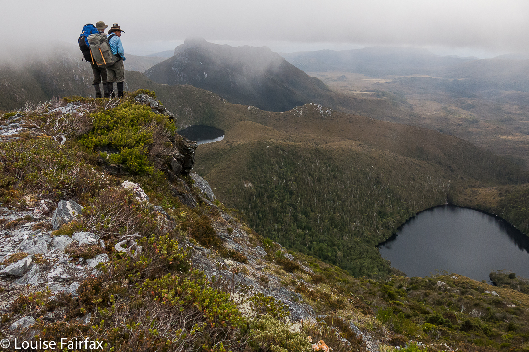
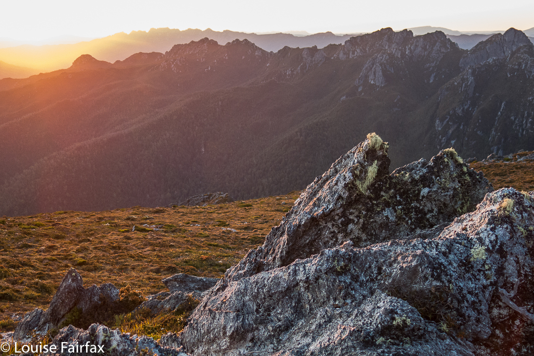
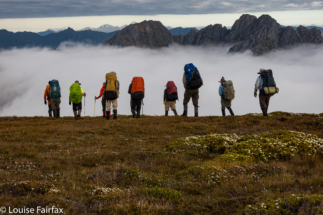
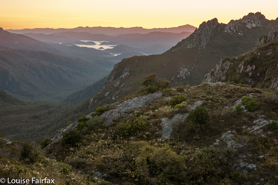
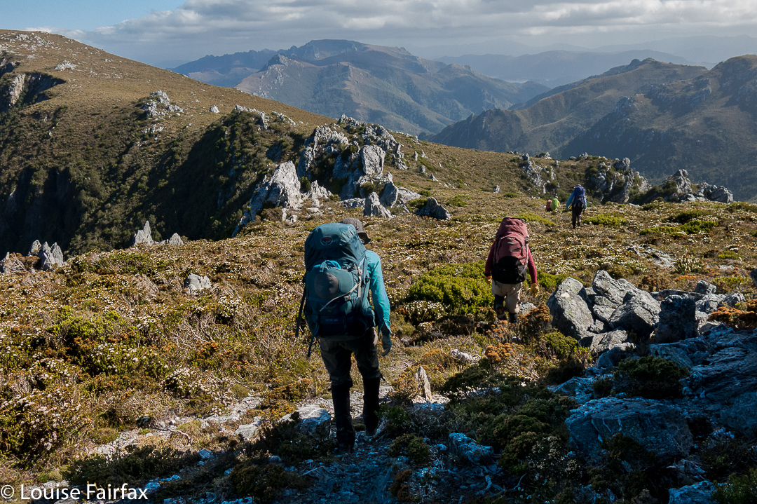
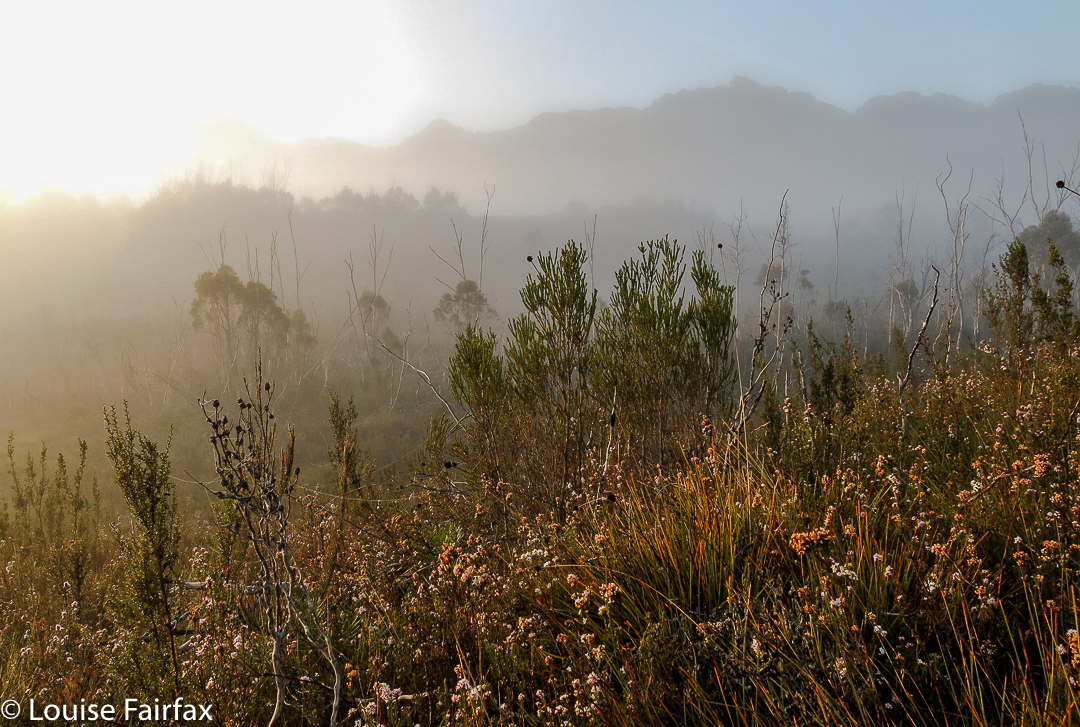
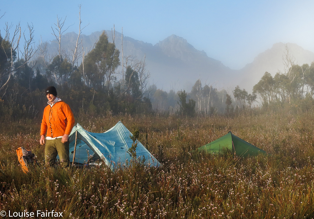
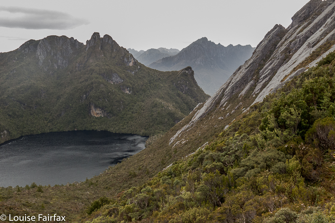
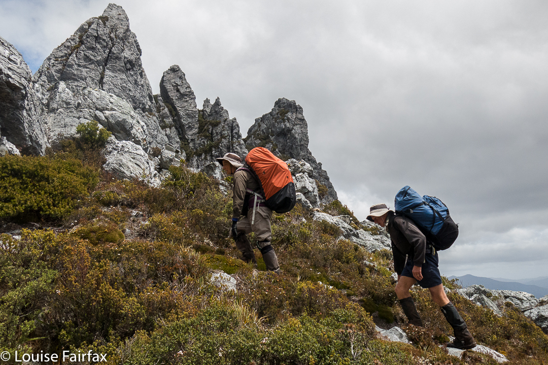
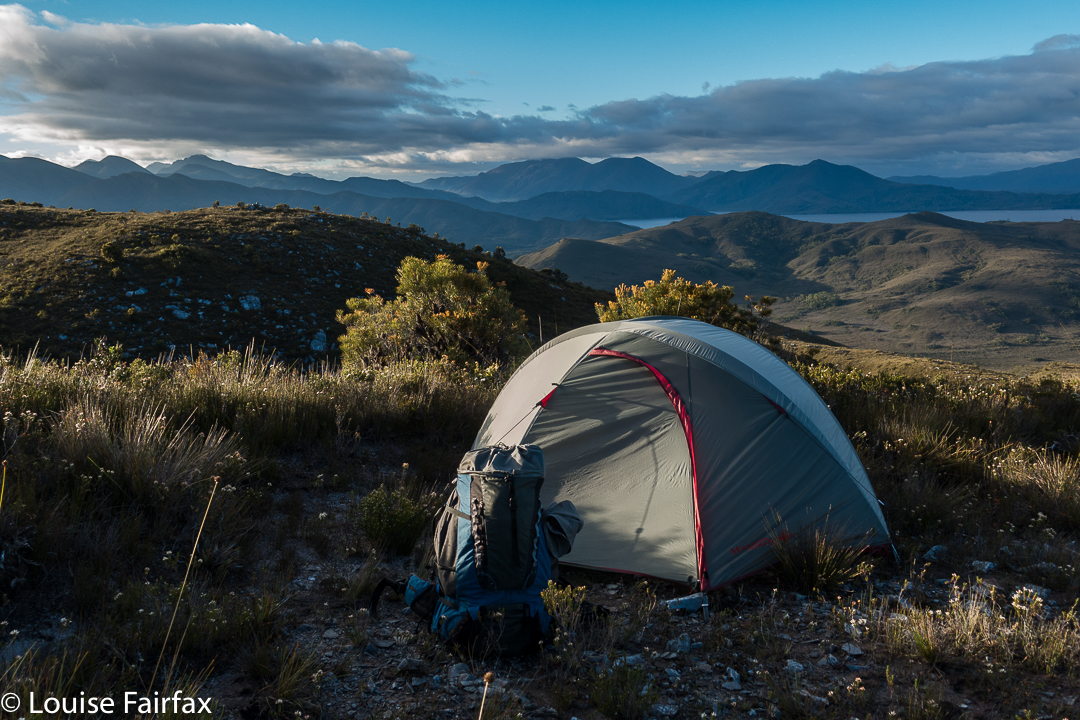
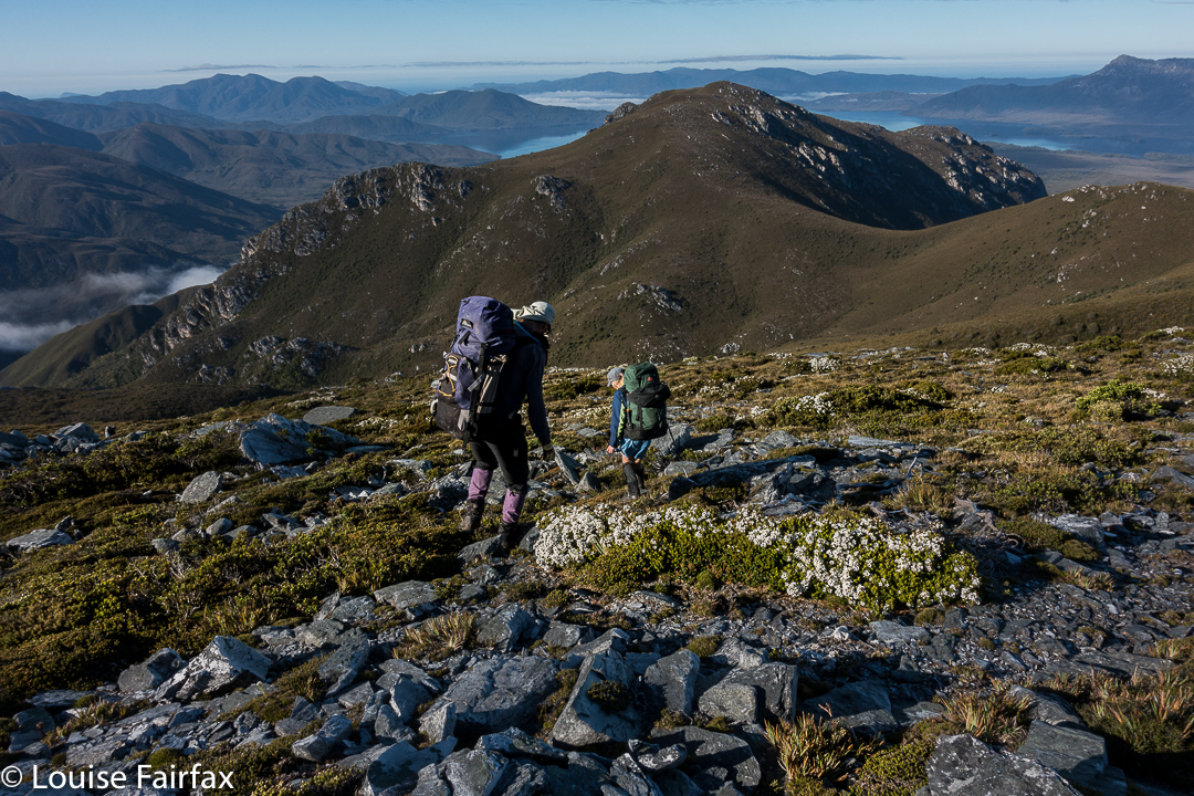
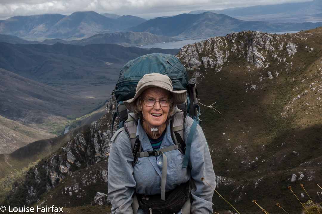
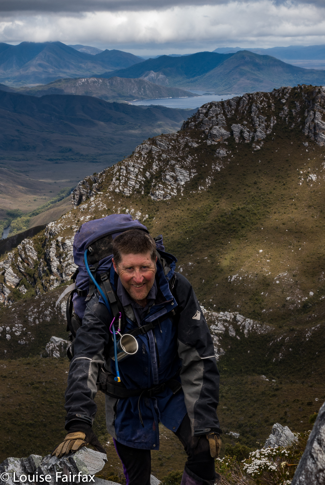
Day 1. The boat trip was very bouncy and rather wet; visibility was poor, and conditions were cool enough for me to wear both my padded and Goretex jackets. The wind was building, but, hey, we were underway, and I was happy. Progress upwards was easy, through low buttongrass, but we made slow advancement as a group, and so had failed to make our intended destination when a halt was called to the day. At this stage, we were only about 320ms above sea level, on a ridge which would, on the morrow, lead us to the top of Mt Wilson. We had nine-day packs, and some were finding the going to be tough. Three twenty metres asl is still high enough to offer fine views (if the clouds cleared); this was a pretty nice spot to stay in for the night, and offered us enough shelter from the quite strong wind. I sucked water out of a yabby hole and a small soak to fill my container, and settled down to cook my freeze-dried meal.


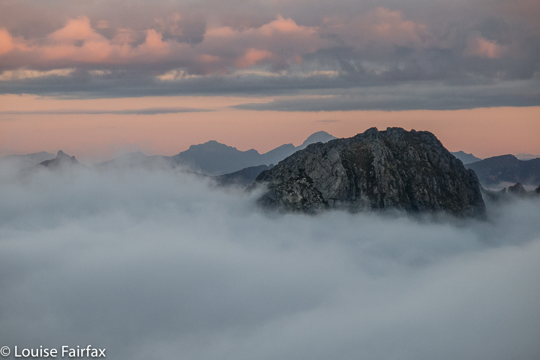
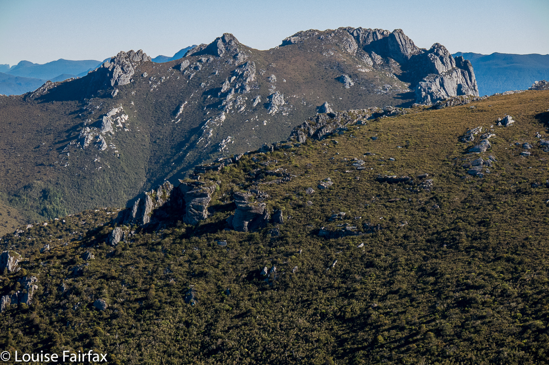
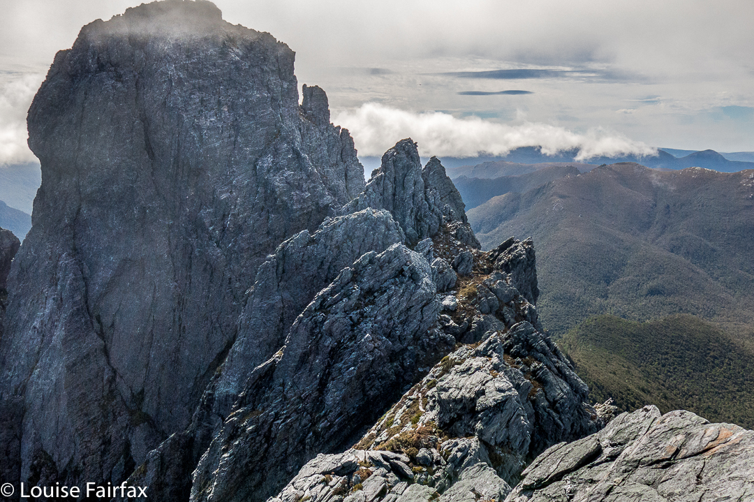
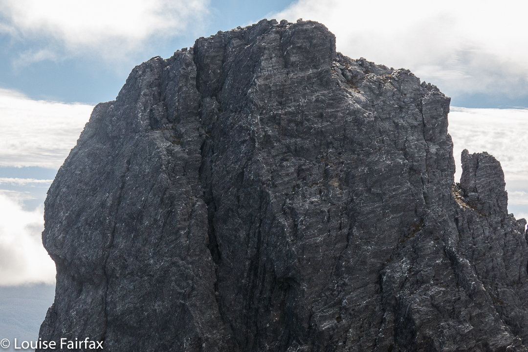
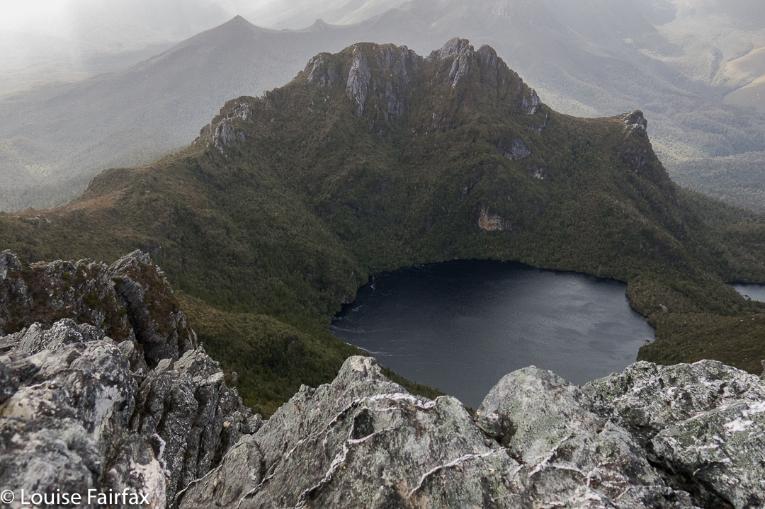
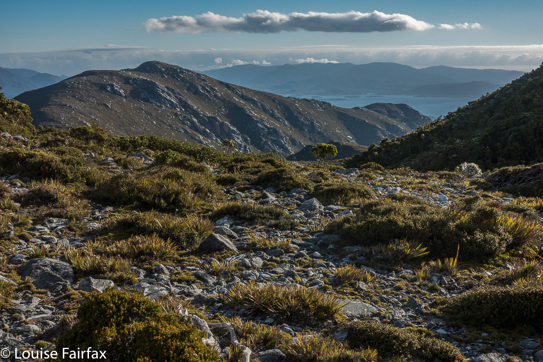
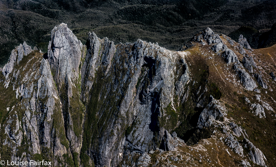
Day 2. The scenery remained lovely, with easy, ridgetop walking, although the outlines of surrounding mountains were murky in the slight haze. The summit of Mt Wilson was slow in the taking, and I could see we would not make our intended destination of Lake Eucryphia. (I later discovered this was no sad loss – the sides were steep and bosky). Mt Norold looked very imposing, and a long way off from the summit of Wilson.
Thus, when we were in lower-lying ground between Wilson and our goal,  our leader decided it would be best if we dropped our packs and climbed Norold without them, and return later to pitch tents somewhere in that area.


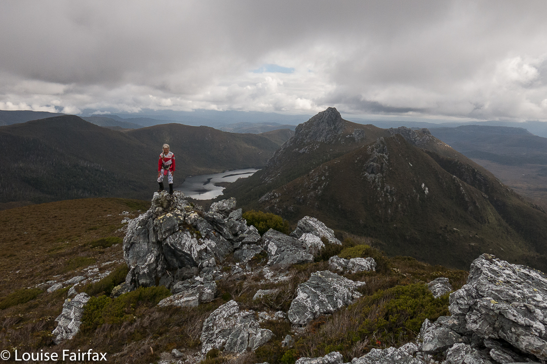
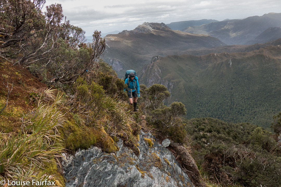
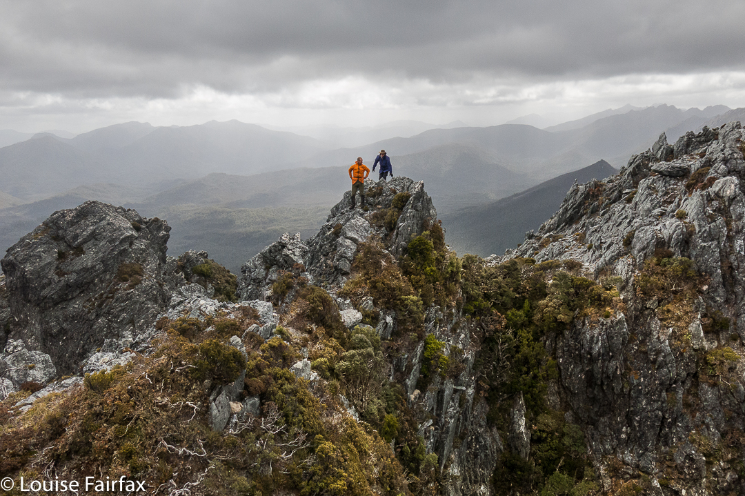
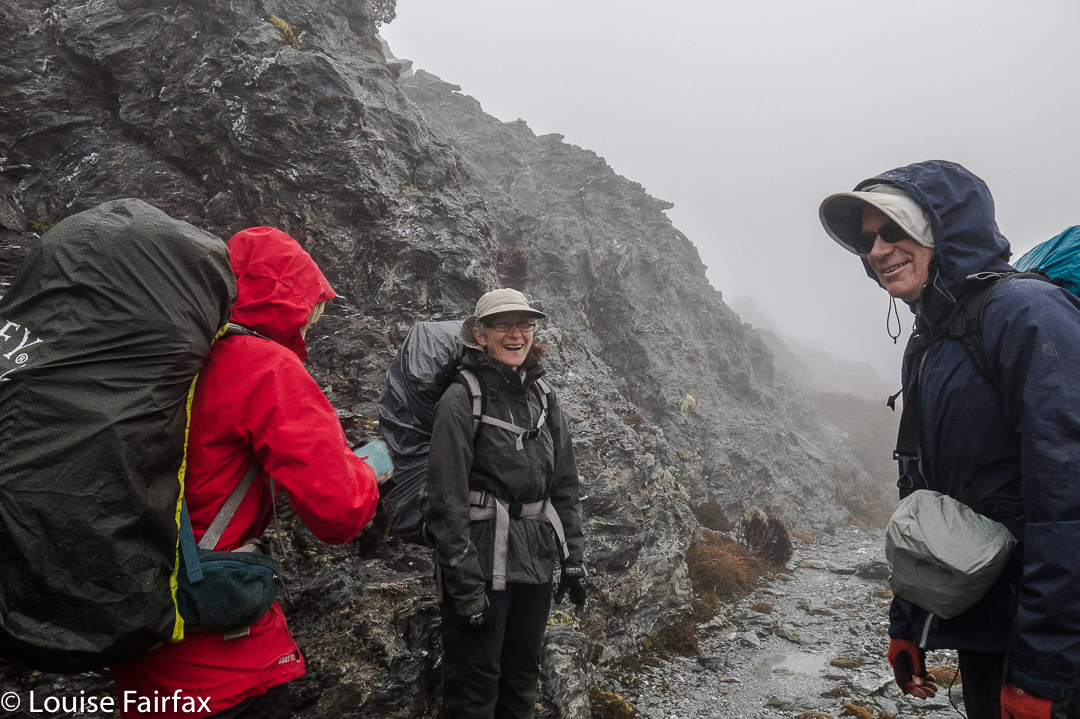
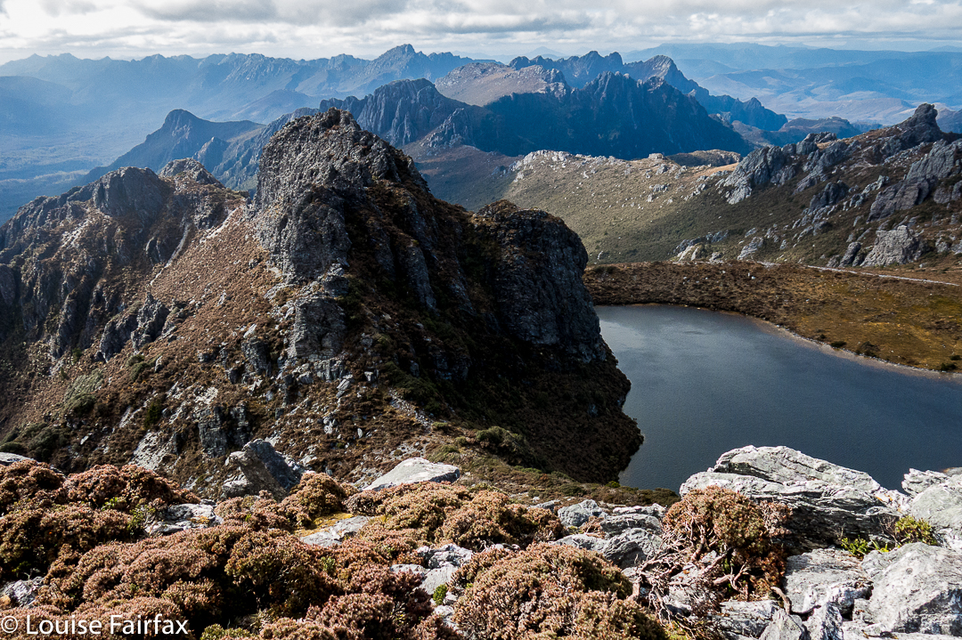
Oh the joy of climbing without a heavy pack. It took no time at all to summit Norold unburdened. On top, two guys said they’d like to explore more mountains to the north, and have a look at the lake we were no longer camping at. Who would like to come too? Only Louise, it seemed. Off we set while the others returned to collect their packs and set up home for the night. It was now very, very windy.
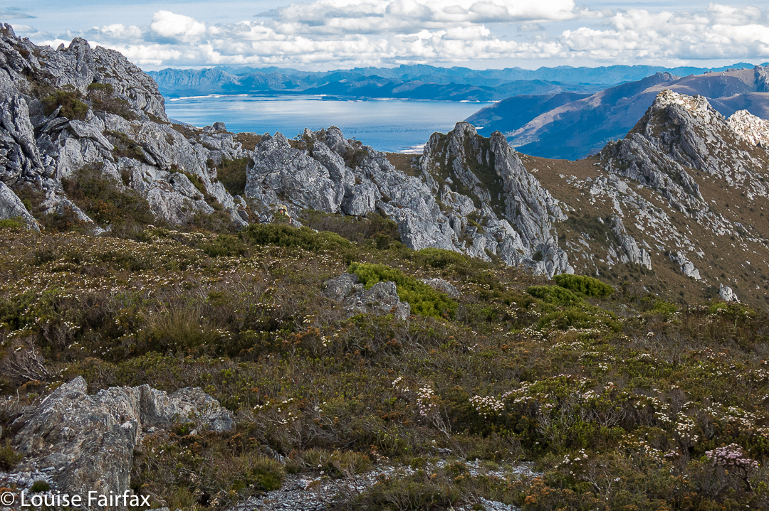
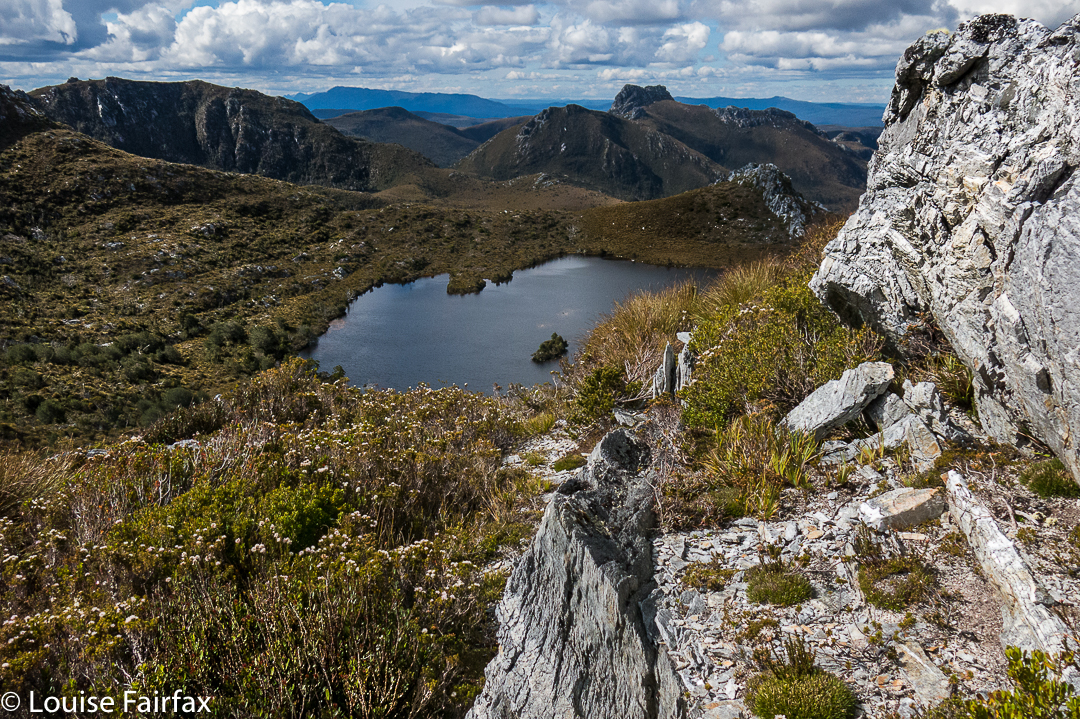
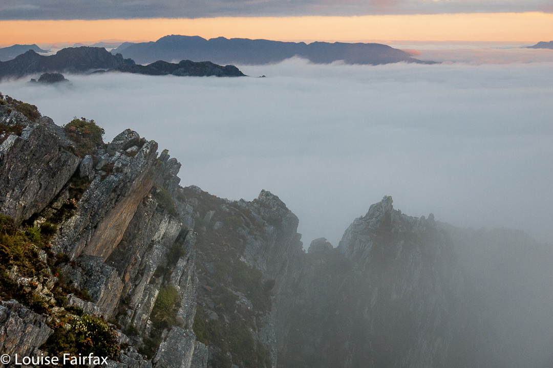
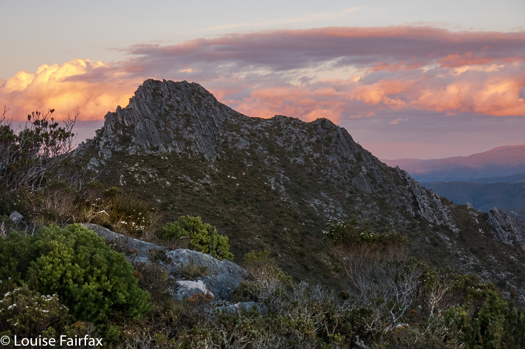
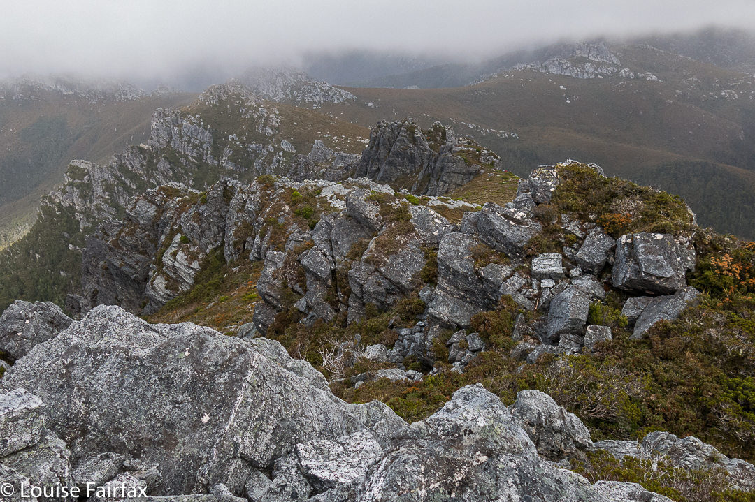
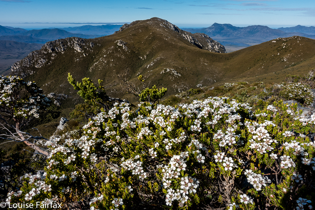
With a walk across the ridgeline to our goal that was only decked in ankle-high vegetation, this excursion was sheer pleasure. We climbed an unnamed mountain that we christened Mount Unloved. I don’t know why it is thus uncared for, as it offered grandstand views of the Western and Eastern Arthurs, and a whole lot more – the best vista of the whole trip – and is far superior to, say, Richea Peak. The wind even abated momentarily while we were there so we could enjoy sitting and staring at our takings.


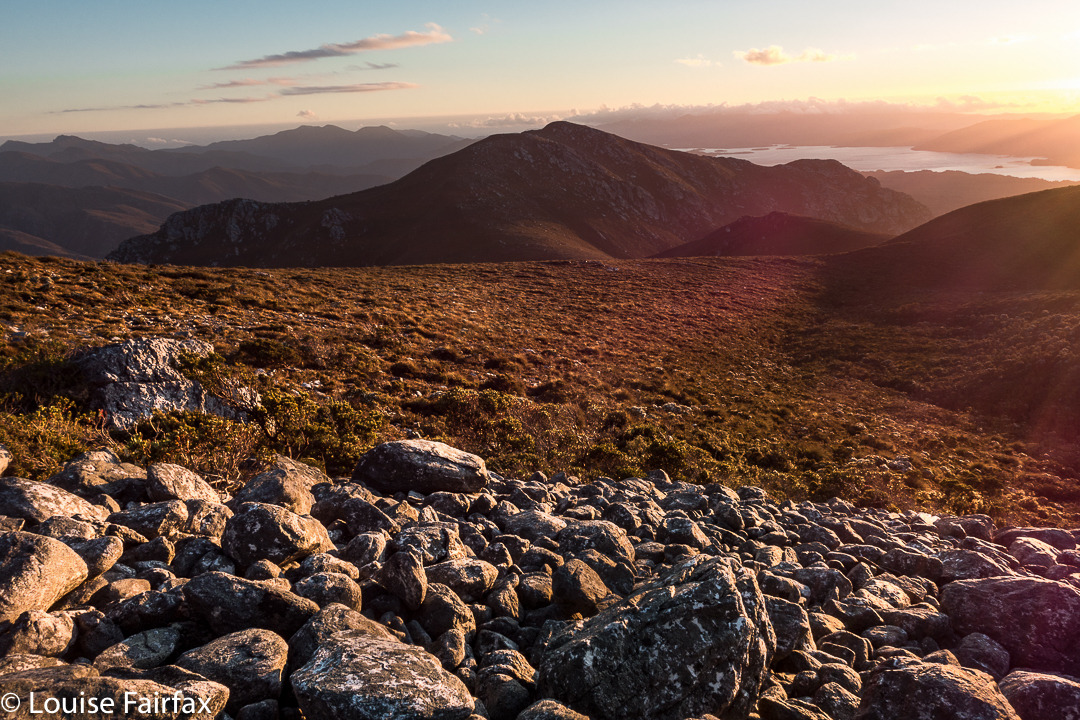
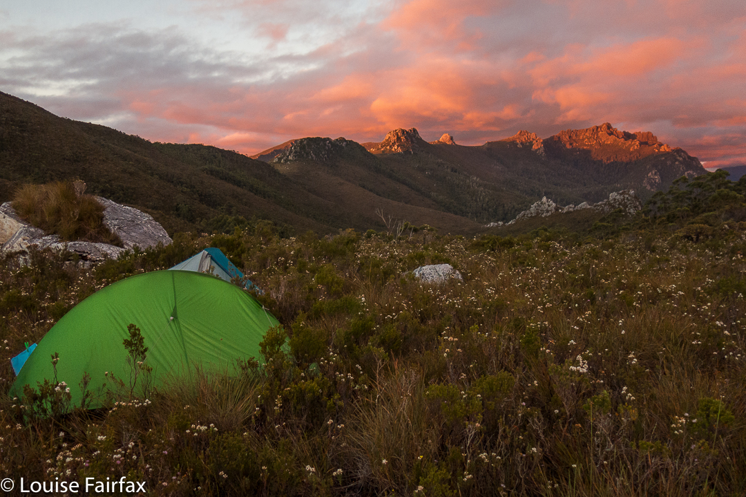
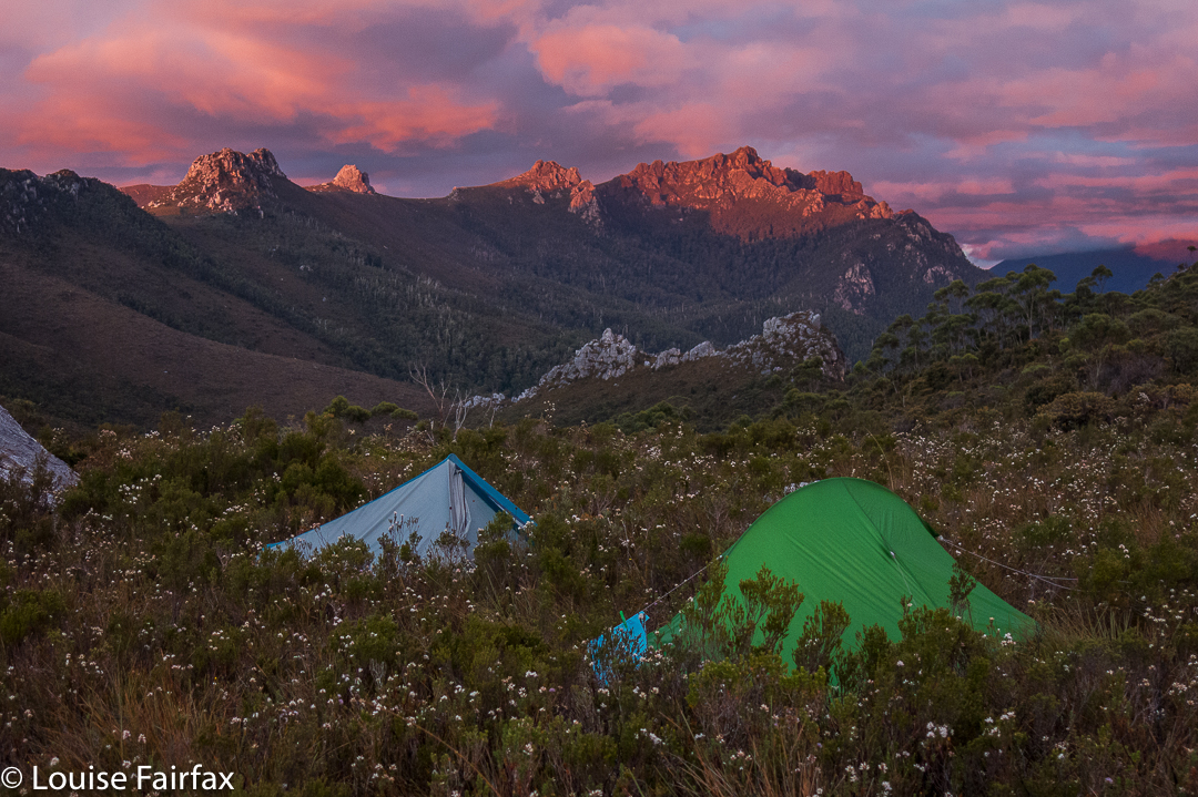
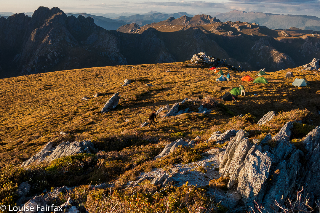
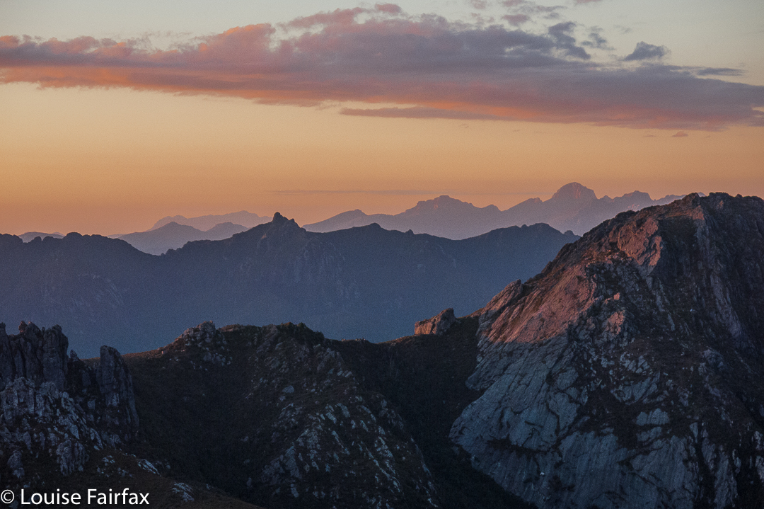
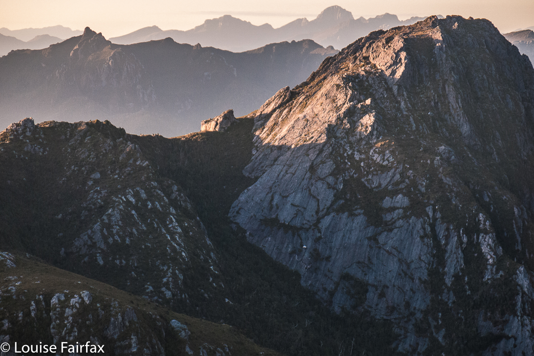
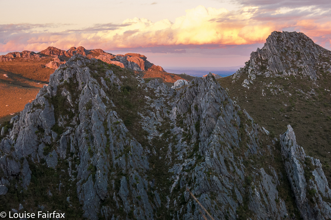
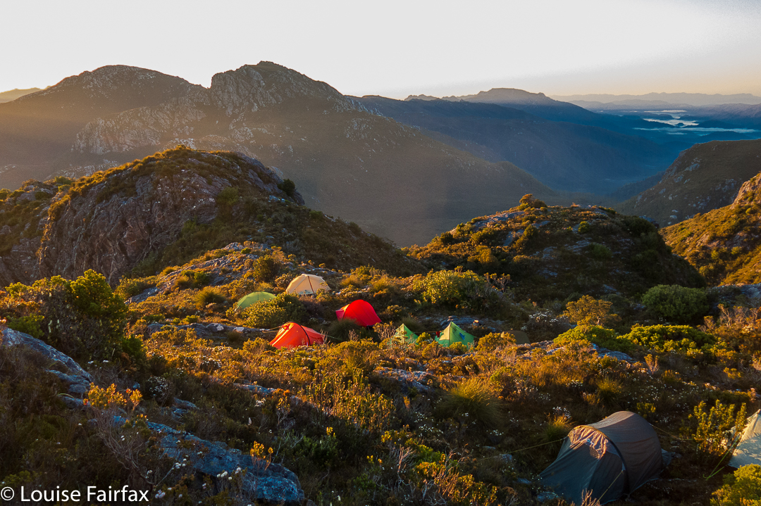
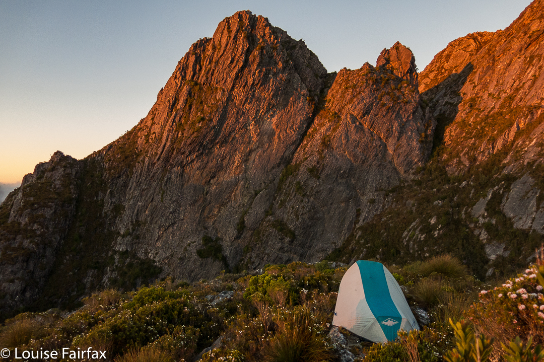
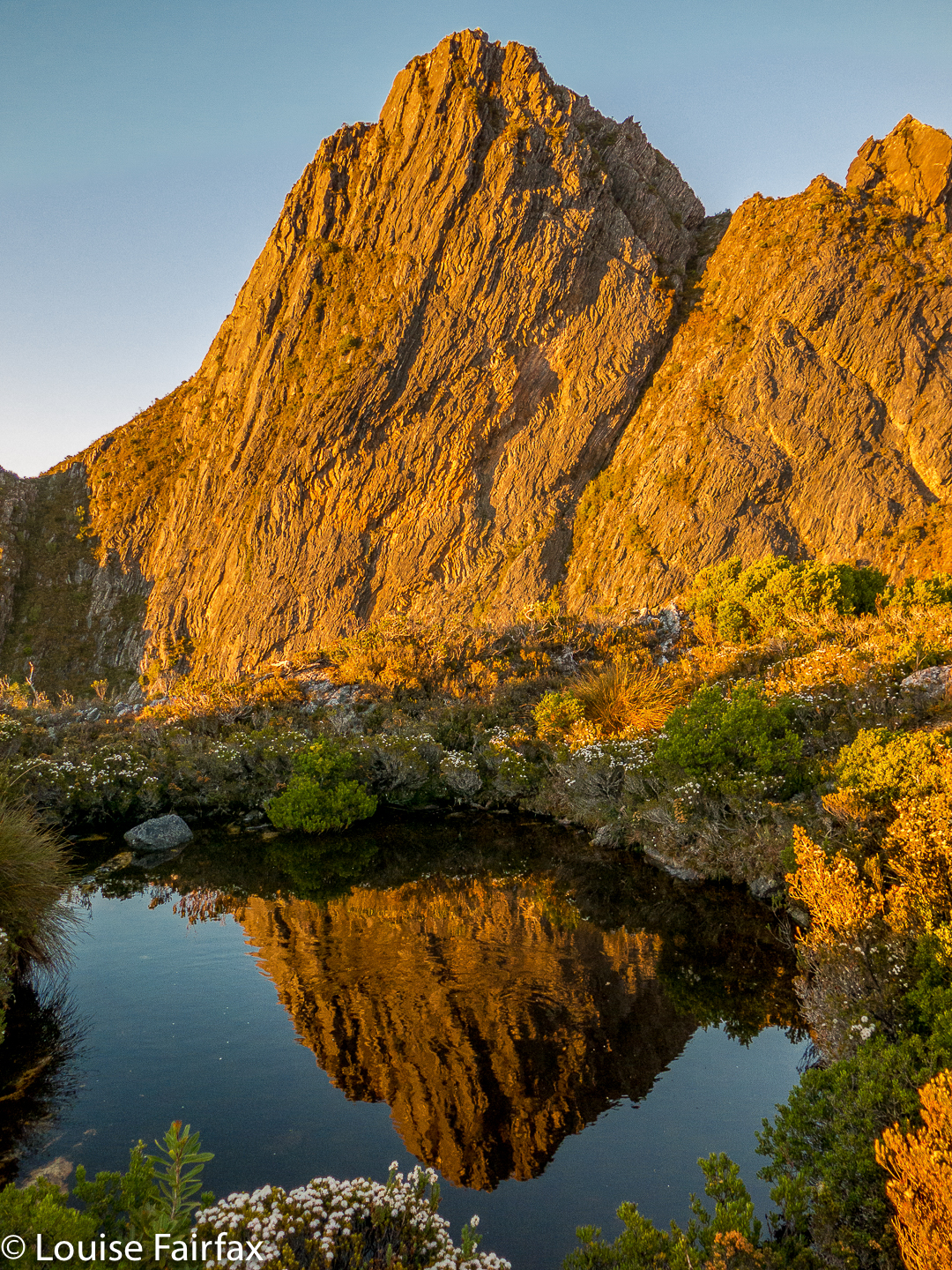
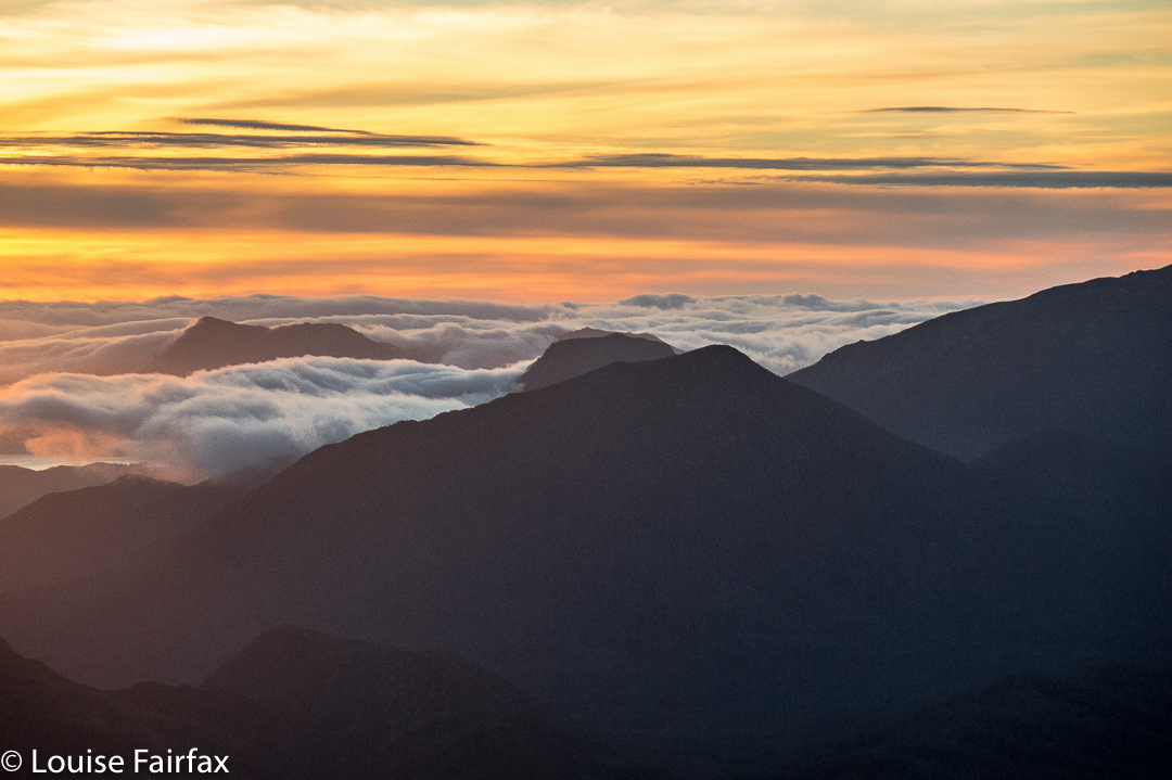
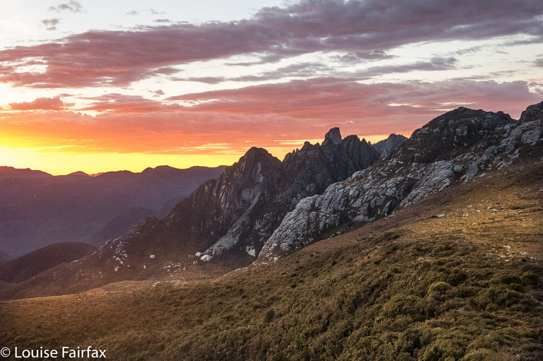
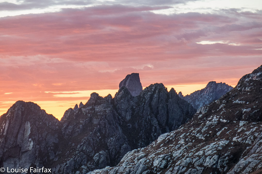
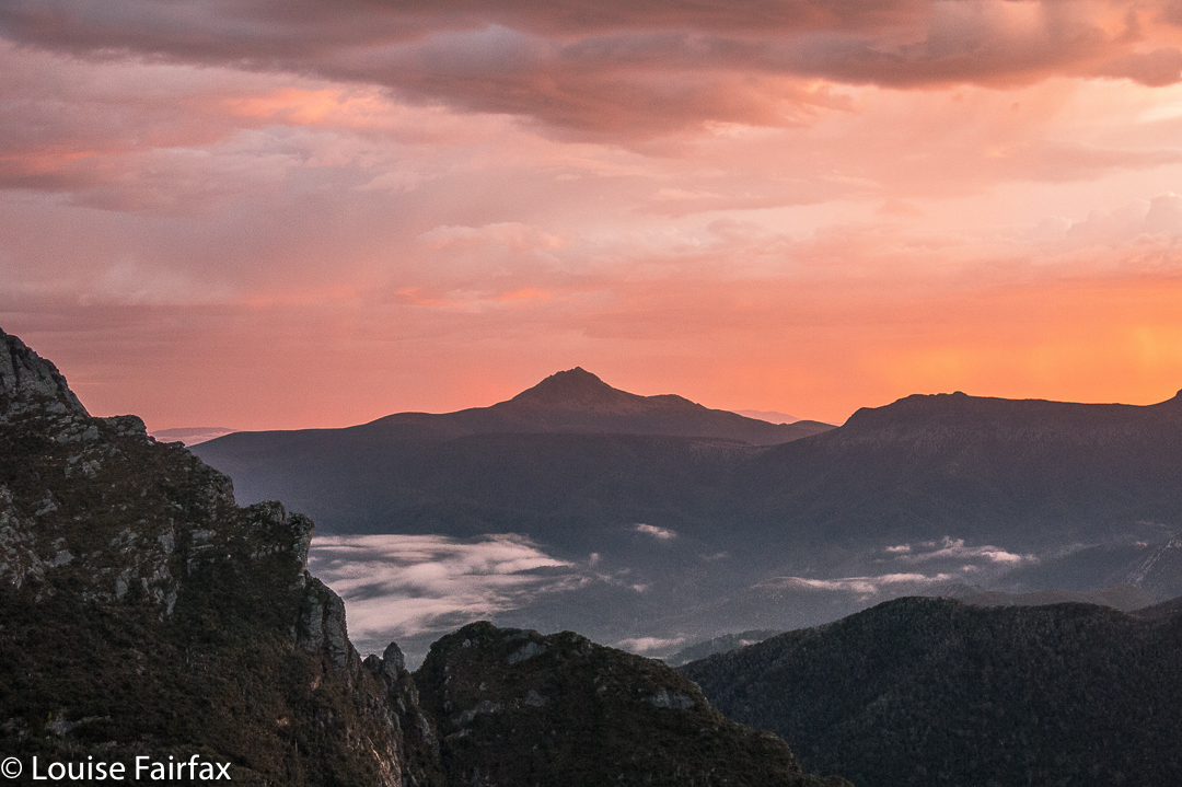
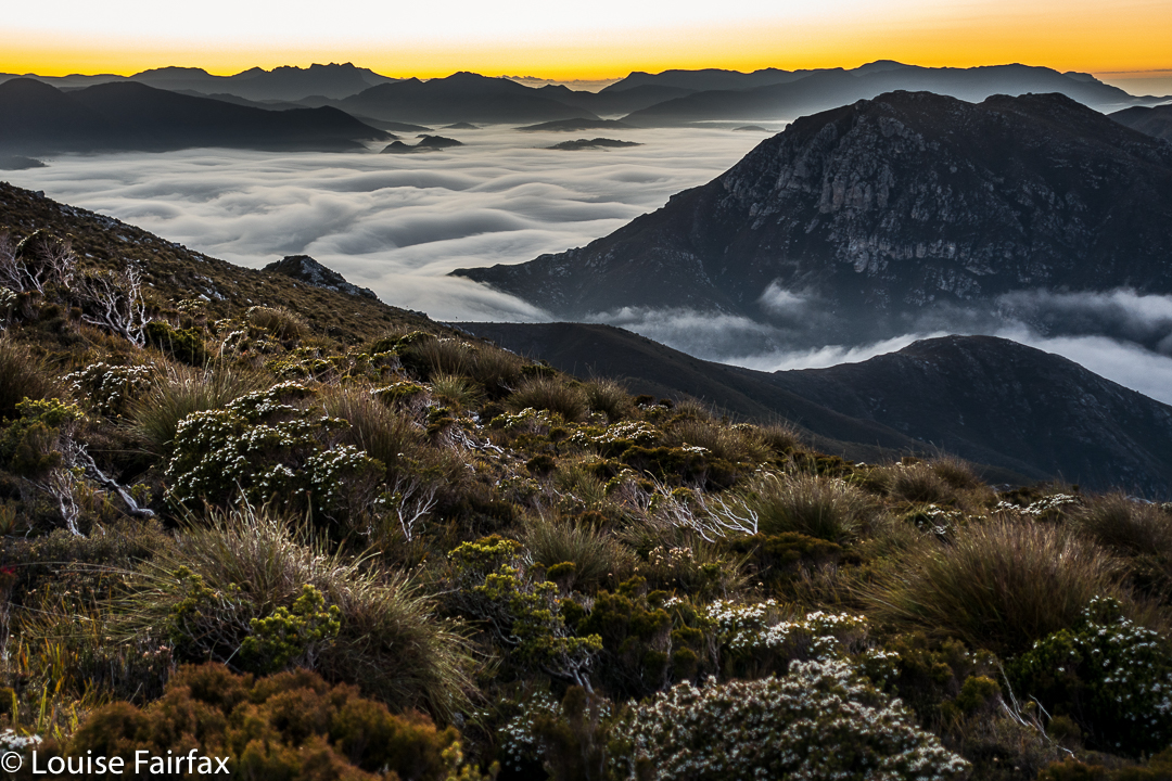
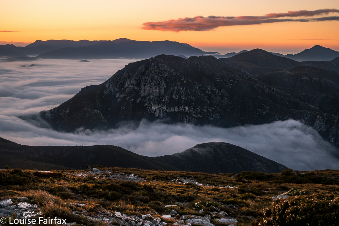
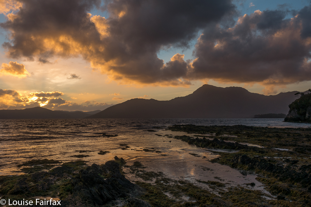
That night, we got our only sunset of the trip. Next morning, the only sunrise. Several of us sat huddled in the freezing wind, armed with several coats, waiting for the sun to go down. The wind was so biting that only two of us remained for the pinking of the sky. Next day, I was a solo observer of sunrise.
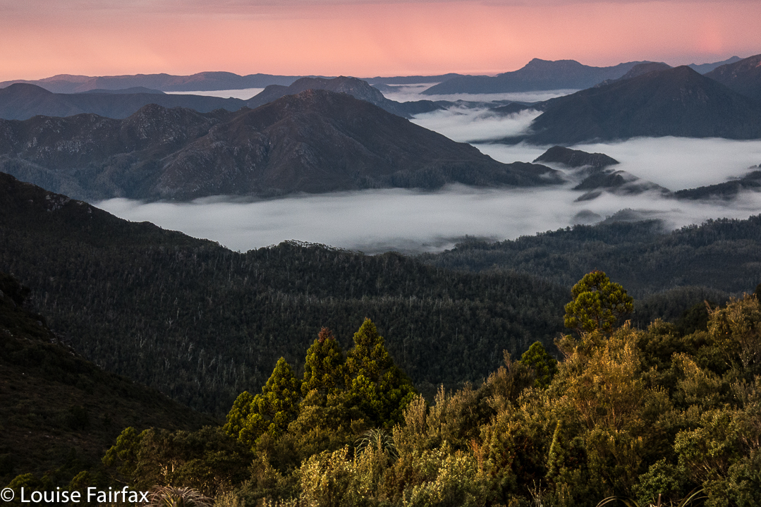
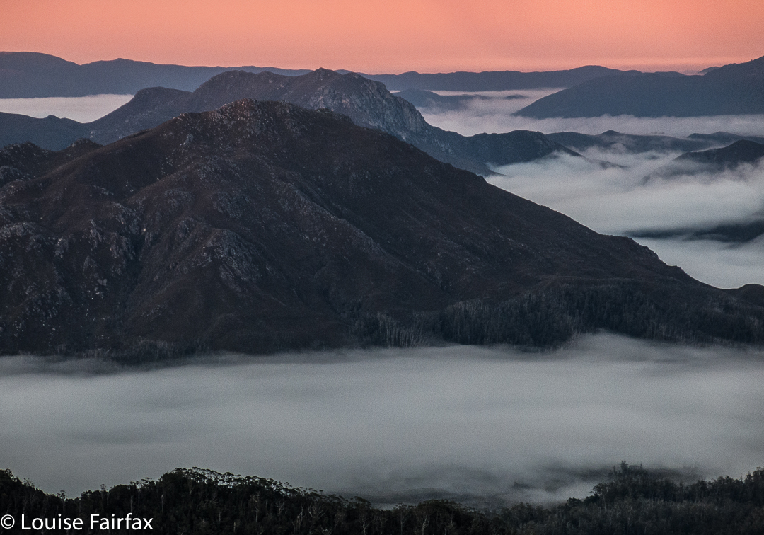
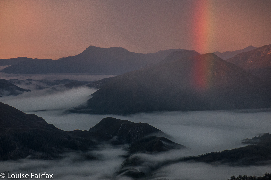
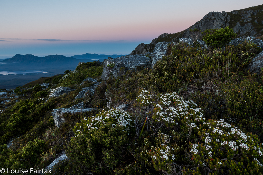
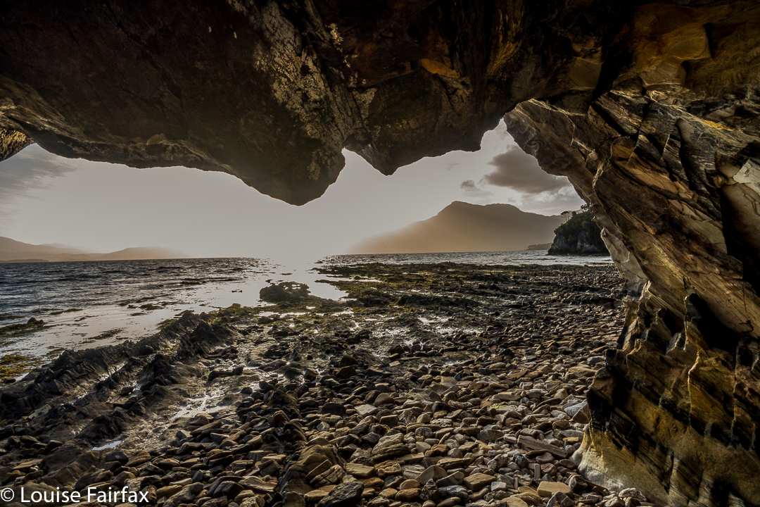
Day 3. The hour surrounding sunrise on this day was one of my favourite hours in the whole trip. I’ll let the photos do the talking:


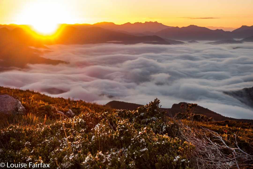
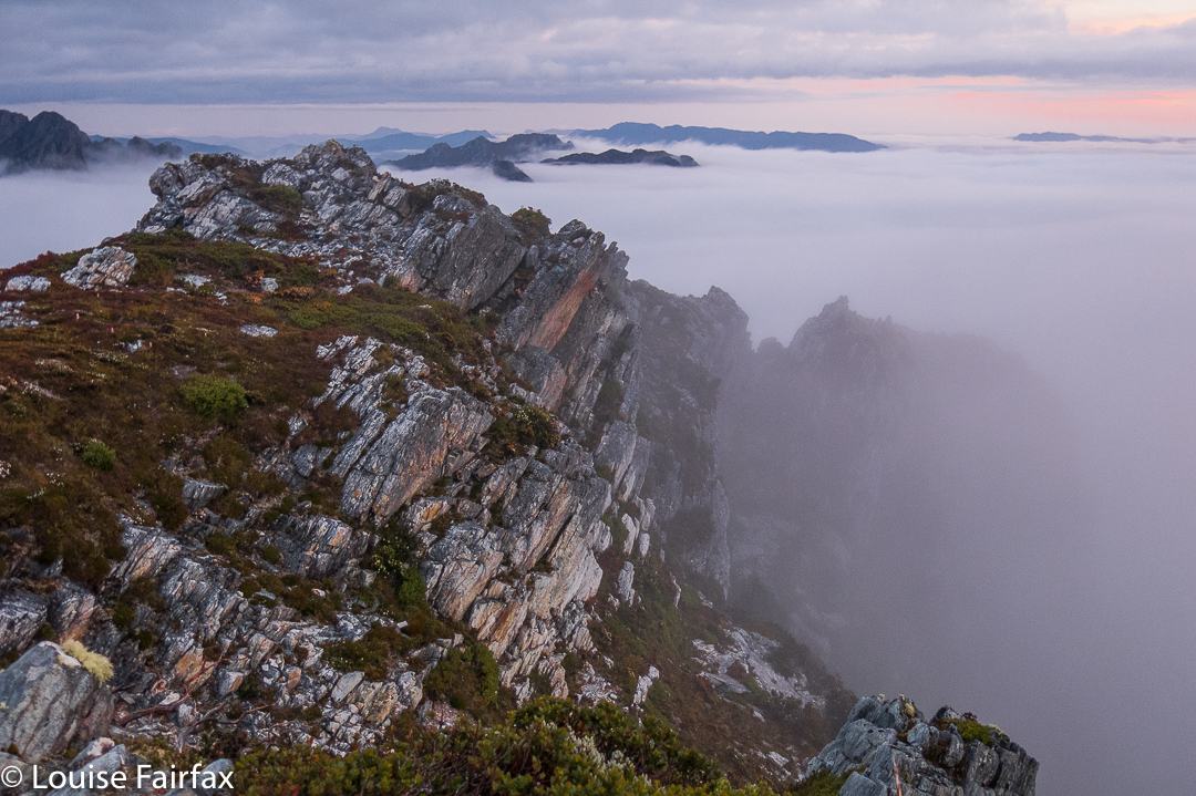
Full of joy, I returned to the tents (I had climbed back up the ridge to take these shots), worried that I might now be running late. Today, we would descend to the Old River, to only 40ms asl, thus losing the beautiful height we had laboured so hard to achieve.

From the ridge, this descent looked stunningly steep – and it proved to be every bit as scarped as it appeared from above.


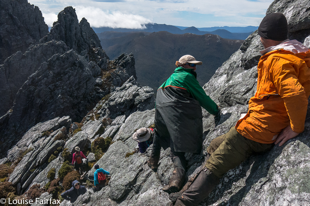
It was a tough climb, sometimes using trees instead of ground to get ourselves down, sometimes sliding down several metres of almost vertical ground, letting ourselves drop off little cliff-faces, hoping the landing would be OK.


Karen, pondering the drop to the river below, which you can see snaking through the valley.
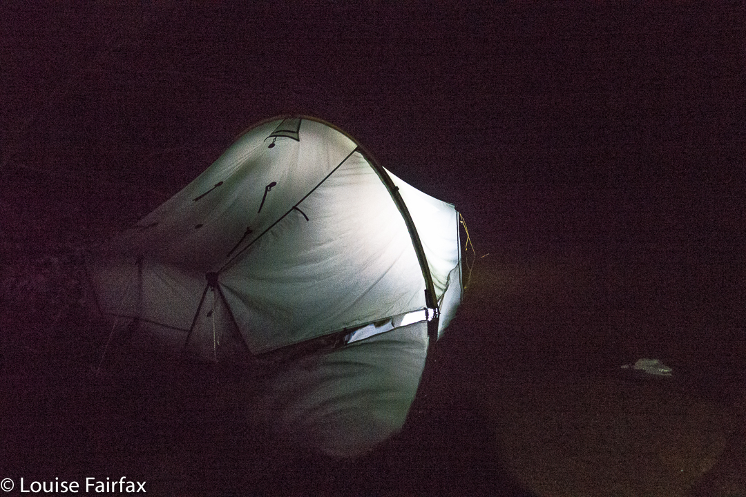
That night was memorable, and I don’t think anyone got much (any?) sleep. It was quite frightening for some of us, actually. The strong wind of bedtime, grew to be an uncontrolled monster by the early hours, and was gusting with such force that the tent fabric was thrashing around, and making piercing whip-cracking noises every few minutes. The poles bent over towards our faces and then snapped back up, untamed wild beasts that took on a life of their own. Meanwhile, it was raining heavily. I know what it is to have a tent snap in the middle of the night in rain, so lay staring at my pole, willing it to be strong. Others were doing the same.
At 4.15 a.m., a humongous gust snapped the poles of two tents (affecting the four inhabitants). The two near me got sopping wet coping with the breakage. All four had to do repair work in the dark with rain slashing down. It was not a joyous occasion. We were all exhausted next morning, as with or without a collapse of your temporary home, the noise was not something you could sleep through. Rain continued. Our leader, full of wisdom, called a rest day (Day 5) to try to recover, and to dry out, if possible.
Day 6. See natureloverswalks.com/ripple-mountain for a blog on the climbing of Ripple Mountain.
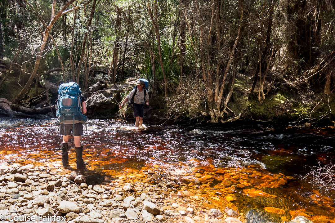
Day 7. This was also a rest day. The rivers were swollen from all the rain, but the forecast indicated the waters may subside a bit. Our route was to take us over two rivers if we were to complete our circuit, so we needed to sit this mini flash-flood out if we wanted our other goals. Voting and discussion took place about whether to cross, how to do it safely, and what to do if we didn’t. (See photo of the swollen Old River in the blog link above). We listened to the light patter of rain on tent for much of the day.
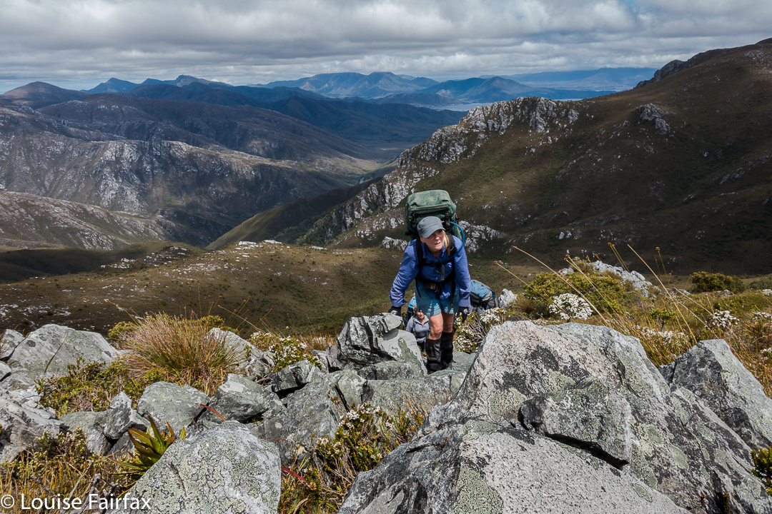
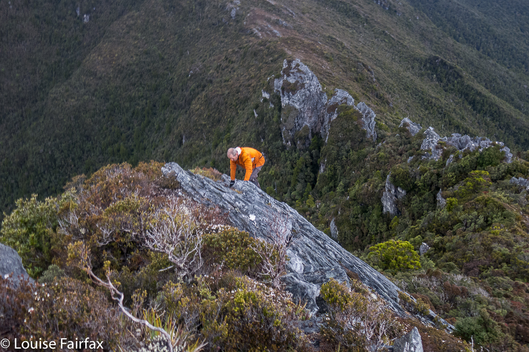

Karen climbs
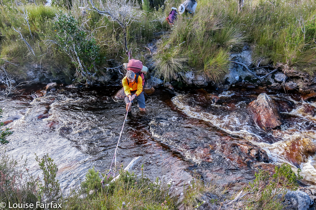
Day 8. Retracing our steps won out in the end. Several of us were unwilling to take the risks involved in a double crossing of unknown depths and strength, involving the possible (probable?) risk of hypothermia attached, especially if equipment got accidentally wet. We didn’t have appropriate gear for such a crossing.


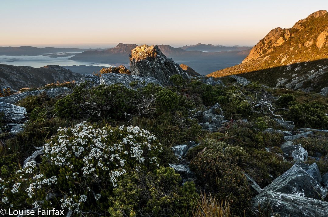
Maureen the wonder woman, with 760 peak bagger’s points, and 155 Abels to her credit.
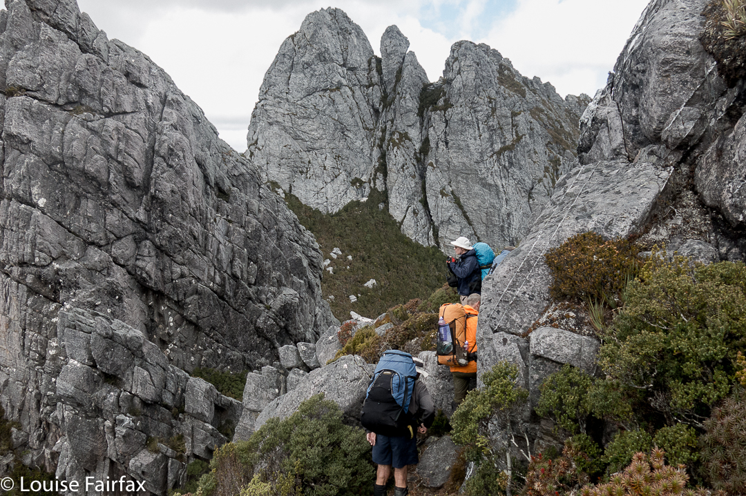
Up, up, up we climbed, some people hurting themselves trying to haul their bodies up the precipitous and slippery slopes. Then, down and up Mt Wilson once more, and part way down her ridge until some members of our group could just not take any more. We stopped in a spot that was pretty sheltered, considering the conditions, and had the last real meal of the trip. We had left a food stash on the other side of the river, but we would not reach it. Time to tighten the belts.


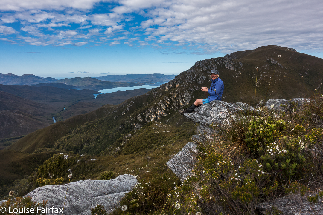
Dale, our noble leader
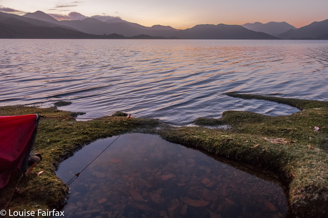
Day 9. On this day, we completed the descent, and chose spots for our tents on the banks of Bathurst Harbour to wait for the boat, which we hoped would rescue us early seeing’s we had no real food left. Meanwhile, this spot was so beautiful I thought paucity of food was inconsequential, and began to hope the ferry wouldn’t appear. I got my wish … and a beautiful sunset as well.


Day 10. One of the most hilarious nights of my life.
Now, this was primarily a group of pretty experienced and intelligent people, so it’s not as if we never considered the possibility that Bathurst Harbour would be tidal. It was partly tidal, we were told. We were also sensible enough to observe the water during the day. Low tide had been at 8pm that night, and we had arrived mid-morning. High tide should have been at around 1.30, just after lunch. It was nothing to worry about. We camped on magnificent grassy verges, replete with magic, crystal clear pools.


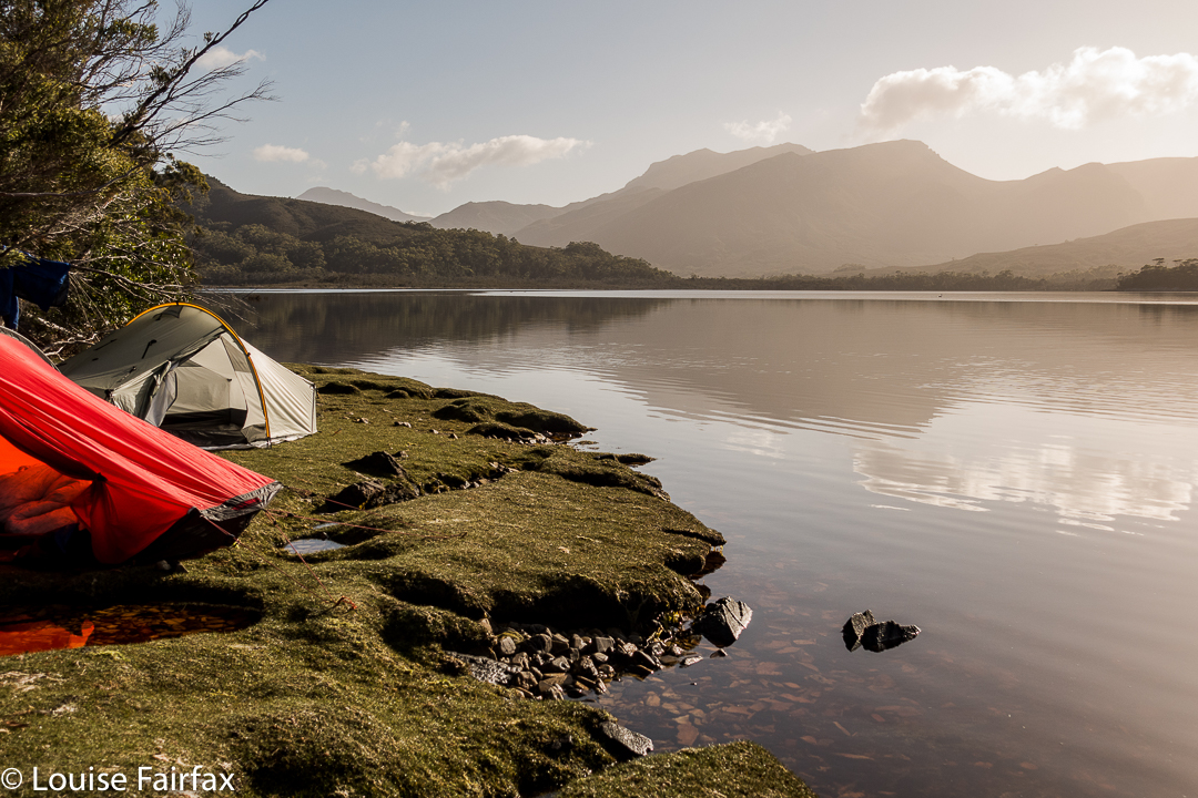
I had the most beautiful afternoon, lazing around my tent, watching the delightful private bath right outside my vestibule (it had been raining for days – of course the pools were full), and later, walking around the point for sunset, as above.
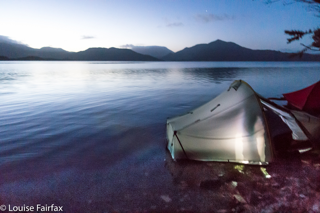
At 2.30ish, I got up to go to the toilet. My torch was on, so I saw nothing beyond its cone of glow. However, I love seeing the stars at night, so went back out without light to gaze at the Milky Way. Wow!!!! And there lay another wow: water was up to the edge of my vestibule (I could now see, seeing’s my vision was no longer reduced to a torch sector). I looked across to Maureen’s tent. Hm. It was half way up hers, but I knew she was awake, and she said nothing, so I assumed all was well. I did my maths: high tide would be 8 + 6.5 = 2.30 in the morning. OK. We were now exactly at high tide, so I’d stay awake to make sure everything (like, my maths) was correct, but all seemed to be in order.


Maureen’s island tent (at 4.15)
Shortly afterwards, Dale came along to tell us to evacuate. His tent was fully flooded, everything sopping, and he feared the worst for all of us. Maureen and I, however, elected to stay put, and “watch and wait”.
Twenty minutes later, the water was still rising, so we cleared our gear up into the trees, and sat on a rock together to watch the show.


5a.m.shot
Actual high tide came at 4.15, so we did a lot of waiting and chatting and laughing, as we thought this was terribly funny. When we realised from our little rock marker that the tide was at last on the wane, Maureen made us a hot chocolate, as neither of us wanted to return to our tents: Maureen, because hers was still inches deep in water (inside); I, because, although my inner was dry, the vestibule was still pretty sodden, and it was now so late, or early if you wish, that I wanted to hang around and photograph the dawn. We continued our vigil.


5.30. Pre-dawn glow
No one slept that night. I think Maureen and I got the most fun out of it. The boat didn’t rescue us until after 3pm, so there was plenty of time to dry out. We’ll have fodder for laughter together over that one for years to come.


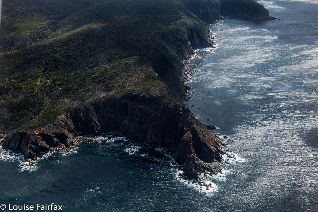
Did I mention that the flight home was pretty good? (Federation Peak. That’s the one you don’t want to fall off!!)

Castle Crag / Falling Mountain 2016 Jan

Falling Mountain and Castle Crag. Feb 2016

View from Castle Crag, with Pelion East, Pillinger and Cathedral in the background.
To climb Falling Mountain, the notes Angela and I had suggested we should head from the clearing below Du Cane Gap towards the rocks from the latest fall off the southern end of the mountain, so we did precisely that, departing that bearing when the bush got thicker than we liked. When we left the direct bearing, we headed a bit right (north), climbing or contouring as the best leads through the scrub dictated (no longer using compass). Eventually this method took us to a wonderful lead of pineapple grass that made easy passage in a green path upwards to the final little climb that popped us out on top, much faster than anticipated in 1 hr 17 from our tents, drying down in the open clearing below. I photographed here, at the highest rock on this part of the mountain, five minutes away, and again at Castle Crag, a nine-minute saunter further on across alpine grasses and a bit of rock.


The route being described in the narrative
Rather than just retrace our footsteps, we agreed to try something different and just drop off Castle Crag. The boulders were surprisingly huge and the going not as kind as our original route, so we decided to sidle across to meet our ascent track. I was leading at this stage and concentrating on the job, using a kind of animal instinct that kicks in when I’m climbing, just following what some non-verbal part of my being feels is the way to go, sensing passages through the maze of rocks when one of the smaller (football size) rocks I trod on became dislodged and catapulted down the mountain, whacking my foot en passant. I writhed in pain, hyperventilating badly, vision blurred, dizzy with shock. Uncharacteristically, I reached for my pack to grab a painkiller. Whoops. They were in the big pack way down there. Angela’s were in the same place. (At least my EPIRB was with me. At this stage, I didn’t know if anything was broken, but found it hard to image that a blow of that force would not break something.)

“OK, no painkillers. We need to get moving quickly. If I’m to get through this, I need to start moving, and now. If I rest, I’ll stiffen up and never budge from here.”

Castle Crag summit cairn, with Ossa and Pelion East behind
Cautiously, gingerly, I put weight on the now swelling blob at the end of my leg and tucked in behind Angela, who was left with the job of choosing a route that would be kind to a one-footed friend. I didn’t feel like exerting the brainpower needed for such matters, and concentrated on using the foot as a stable plank, tucked in behind Angela. Most surprisingly, we were down in 1 1/2 hours. It felt like much longer than that, but my foot was coping well with weight bearing.

Sunset at Narcissus Hut (Lake St Clair)
 
Next morning the sunrise was exactly what I ordered. I do love a good mist

I didn’t dare inspect the damage to my foot until Narcissus Hut. I thought if I looked and saw what I was bound to see, I’d feel sorry for myself, and maybe not be able to go any further. Now, I must say, I have always had the policy that if you are going to hurt a lot on the inside, it is the best thing to have an outer appearance that is commensurate with the inner torture. My foot did me proud. It was grossly distorted and swollen, and coloured a rather nasty combination of red, purple and dark grey. I felt a true martyr.

Leeawuleena, the mellifluous aboriginal name for Lake St Clair that matches its visual beauty with soothing sounds
Despite this magnificent display of swelling and colour on my ankle, I can report nothing is broken. For this, I can only thank my wonderful, solid, leather boots that shielded me from the full force of the bash, and the fact that the impact must have been pretty well back on the foot, so I am extremely lucky in the placement of the collision. My doctor advised rest.

“How many hours do I have to rest for?” I asked (neatly eschewing mention of days or weeks).
She knew the implication of my choice of words, shook her head and smiled wryly (which is why she’s my doctor).
“Twenty four / forty eight hours?” , she said with rising intonation and another smile. I got the feeling she was carrying out a kind of barter: What number can I say that will not be so great that this person rejects it altogether, yet not so small as to be nugatory? She chose a good number.

Deal. I’ll obey that. I did Pilates instead of running and only walked the dog.

Dawn light
I do not feel unlucky at all to have been hit by a falling rock coming off Falling Mountain: on the contrary, I feel very much the opposite, and elatedly relieved at all the things that could have been, but weren’t. I will enjoy the rest of my summer’s bushwalking with even greater gusto.

Spires 2017 Conical Mt, Shining Mt, Pokana Peak

The Spires. Jan 2017


First night on the Spires trip, camping on the Pleiades.
I never set out for The Spires confidently expecting to reach the goal area, let alone the summit (despite our excellent leader). Too many things can go wrong in such unforgiving, wild country; too many others whom I deeply respect have failed one or more times to get there. Weather conditions, for a start, can wrest victory from your grasp, as the trek in is long and hard, and weather can make a huge difference when that is the case. But if you don’t set out, you haven’t a hope of succeeding, so our packs were on our backs, ready to give it a try, and if we didn’t get there, hey, we would have a fabulous experience in the wilderness anyway.


First night on the Spires trip, camping on the Pleiades. 
Certainly, things didn’t begin in a way that engendered hope had I only been there to achieve summits. We had a few glitches on the first morning getting ourselves into position that set our programme back half a day, so we only made it to a saddle part way up the steep haul onto the Pleiades Range before we were obliged to end the day. Here there was camping to be had: well, there was fresh, running water the other side of the saddle, and the ground was kind of level. There was button grass everywhere, and bushes that did not respond at all to my request that they flatten themselves for my comfort. It was impossible to cook in such a bumpy, bushy vestibule, but the weather was mild, and we congregated on rocks to prepare our meals. The mood was jovial. Sunset that night was wonderful. I had an unexpectedly good night’s sleep.


Looking along the spine of the Pleiades.

Day 2.
The following morning, we set out to finish our climb up to the Pleiades Ridge. This is very, very steep country and the bush was thick, the going hard.  Some members struggled, but thanks to a team effort, we all reached the ridge, and continued on our way along it, which seemed fine enough until we hit the final cliffy mound (huge) near the end before we would make a slight “left hand turn” at a different knob, continuing towards Conical Mountain (heading NNW, while the ridge leading to Pokana Peak deviated east). But first, as said, we needed to get around the final knob before the “intersection”.


Looking along the spine of the Pleiades.
We chose right. There was even a pad of sorts. It was so steep, I was grunting as I pulled myself up, and was accused of trying to have a tennis match. The last time I grunted like that was climbing up to Slatters Peak in early 2013. I’m not sure if it was the steepness (and extreme weight of my pack), or just the fact that my protracted illness of the last three months has robbed me of too much precious condition, but, whatever the cause, each major heave upwards elicited a noise worthy of Maria Sharapova (well, not quite that bad). This part of the route had a few spots where there was a very steep drop below our ledge. It’s funny how different varieties of exposure have altering reactions from people. Because there were trees below, and bushes to cling to, I felt fine, although, of course, I did feel the need to be cautious. Somehow the trees under me reduced any sense of great threat.


Looking down to the lake for night 2.
There is a small lake below the ridgeline after one has waved goodbye to Pokana Peak, and this was to be our campsite for the second night. As we descended to it, I noticed a lovely little beach with small sandy shore far below and hoped to camp there. Unfortunately, this spot was a bog, with a squelching, sinking vestibule area and button-grass lumps in abundance where my body should lie, but there was nowhere else to go by now, so I pitched and hoped it wouldn’t rain, which would turn my little depressed area into a tarn. I cooked on a nearby rock, joined  by Johnny, whose tent was nearby. Our rocky kingdom was fine.


Rohan and David survey lakes two and three, beyond our own one, on Day 3

Day 3
.
At last, after three days’ steady, and fairly exhausting climbing and pulling and heaving and high-stepping, we were heading for our first actual mountain (still laden with our heavy packs), and, joy of joys, it was an Abel: Conical Mountain. It still looked like a giant ahead as we snailed our way towards it. I was very happy to at last have a summit under my belt, and an Abel at that, but the big one lay ahead.


Me, above Lake Curly, looking towards Mt Curly.
Shining Mountain is lower than Conical. That should give heart, but the drop between the two did not. There was more height to gain, and more bush to fight for my out-of-condition body. We celebrated the views from Shining fairly early in the afternoon. The day was now very hot, and progress was like a pyrrhic victory in a battle.


Dale on a fun spot beyond the summit of Conical Mountain.
Shortly after summitting this one, our noble leader pointed out that descent into the valley way, way below (almost out of sight, the land was so steep), would be a hot and unpleasant affair on such a day. He said it would be possible to camp up there and still climb The Spires on the morrow.


Shining Mountain shelf campspot. The Spires lie ahead there across the valley.
Now, considering the fact that I was of the opinion that if God wanted to choose an earthly spot for heaven, He could hardly go better than the one in which we were then seated, this was joy to my ears. The view was fabulous; we were high in the sky with a sense of infinite space all around and mountainous views to die for. Yes, yes, please: I wanted to sleep just here, to linger in this place and soak it all in. THIS is why I bushwalk. This is the reason I come, and I did not want to go away. We stayed.


I chose a secluded spot beyond the other tents and enjoyed scenery that filled me with joy and peace. My spirit soared with pleasure. This is The Sublime, not just the beautiful. Spiritual pleasure in such a place is not confined to indigenous people. Wilderness is important to the soul of all of us: the chance to be in a place of the infinite and be still in a way that cities do not allow. My church is up here, not in a dark, musty building made by humans.


I wandered about, chatting, but mostly I sat and stared, just enjoying the existential pleasure of being. I no longer cared whether I made any more summits. I felt complete.


Day 4.

After a glorious start to the day, the climb down to Reverend Creek and then up to The Font was bothersome, done in temperatures that told you swimming would be a much more pleasant pastime than this. However, we were there to climb, not swim (that would come later for the Brave).


We dumped our packs at The Font, and began the serious business of our actual mission: to climb The Spires. But first, the vote was to climb Flame Peak on the way, to score two easy points in case we couldn’t get the Big One, which was much harder.


Unbelievably, my camera let me down at this part of the day, and refused to allow me to shoot. The others suggested that the heat was the problem, and they were right: it functioned again that night, but for these two peaks, the object of my quest, I was effectively cameraless.


But let me describe the route up The Spires. From the Flame-Spires saddle, we descended around the face of The Spires, curling right, until we found a ledge that led to an internal saddle within the Spires summit. The going in this part was easy, with plenty of bushes to grab. It was even shady. Hoorah. It was fabulous to be free of our packs at last. I felt so light and agile.


And now the photos move straight to sunset, due to the broken camera.
After the internal saddle, the fun of the final climb began.  We curled left, to be faced with a sloping rock that had no handholds for safety. We had been warned. Some crawled; some wormed. We all got there. It didn’t last long. First object overcome. Had anyone fallen, it would probably have been fatal, as the drop, although not of Feder proportions by any means, was probably enough to be one’s final acrobatic act.


After the slope, the rest was fun. Yes, the drop was now monstrous, but the handholds were secure, and I just didn’t look at the drop, so can’t tell you anything about it, although I could feel Great Space below. With security of holds, it didn’t matter. Eleven set out for the final climb. Eleven made the summit. Fantastic job, oh leader (who, having been there before, and now sporting some gastric bug, did not accompany us).


It was time for another vote. Should we go back the way we came and face the slopey bit again, or do a circuit continuing on towards False Dome, maybe climb it too, and come back that way? We voted for a circuit, so off we set. The saddle before the first internal mound offered no way down. Nor the second. After much climbing and humming, we voted to reclimb The Spires from this new direction, and retrace our steps. It was a fun adventure, and a good way to fill the afternoon. Soon enough, we were at the campsite above The Font, choosing our real estate for the next two nights and enjoying the views this place had to offer (tremendous).

Day 5.

This was to be a packless day, climbing Innes High Rocky, a mountain that pleased me greatly because of its stunningly remote position. Dale – one of our more adventurous members, and an amazing team member who averted many an attempt at team failure with his admirable ability (and astonishing willingness) to carry other people’s packs when they were struggling – went even more remote than that, and climbed Philps Lookout as well. The rest of us found Innes High Rocky to be exhausting enough on a day that felt well over thirty, and in terrain that offered very little water, but button grass higher than my waist to overcome for huge stretches.


One of my chief memories of this day is of us all crouching beside walls of rock, trying to shelter in tiny patches of shade. I even voluntarily sat on a scoparia bush, as that was the only way I could get some shade. This is not a hobby I will pursue. The day was ten hours long, even though the actual climb only took five and a half hours. The breaks were needed!! I enjoyed the chance to linger longer in a place that I will probably never go to again.


Innes High Rocky still a way off yet.

Day 6.

The Font
Now we entered the business end of the trip. Camped up high, we had access to BoM readings, and the weather for Tuesday was pretty bad; for Wednesday, absolutely deplorable. We had two days to get out to beat this change. If we could reach the Lake Gordon shore by late Monday afternoon, there was a chance Andrew could get us all out in his flimsy (sorry Andrew) dingy before the projected winds made the lake perilously rough. It was now Sunday morning.


Off we set, on a mission, and successfully walked two days at once, in what was a long day. This day was so windy, I had insurmountable trouble walking in anything resembling a straight line, being constantly thrown to the side by sudden gusts. I found it exhausting fighting the wind like that all day. We camped this night at the lake of our second night.

Day 7.
On we pushed in our race against the weather, but not so fast that we had to omit Pokana Peak, the final mountain, and Abel, of our quest. It was grand to be once more, albeit it only momentarily, free of our packs.


Pokana summit view
The day was long, the work was dehydrating, with the yabby holes from which we’d drunk on our way in now almost fully dried up by the way out. Valiantly the group pressed on, well aware of the penalty of easing off.

Andrew’s first trip across the Lake was dicey, and he feared it would be his last for the day, leaving a herculean task for the morrow, but he realised he could make another, and yet another, so did. My tent was already up when the boat returned, but I was neither worried nor disappointed – although I did brace myself during the night for a possible long haul at this spot. I knew that on the Wednesday, if still stranded, I would not be able to cook in the winds that had been forecasted, so prepared mentally for no warm meals as well. Meanwhile, the lakeside spot was rather fun, and I cooked a huge dinner in celebration that I didn’t need to eat abstemiously any longer (Laksa soup, “roast chicken” – so they say – plus apple pie for two for dessert). I had enough food still to last most emergencies, unless they endured for about a week. My rucksack still had over 2 kgs of extra food (I suffer from food angst, so had taken a little too much to cover for this), plus I had left a stash at the lakeshore in case.

Next morning, most unexpectedly, we heard a boat at 6 a.m., and saw Andrew, somewhat hassled by the emergency of the situation and the task of getting two more boatloads out before things became impossible. Under deep stress, knowing what he knows about boats and lakes and winds, he expertly handled this final exit. I have to confess to being terrified as we roared our way through closely placed dead trees in the lake at frightening speed (sorry for the lack of trust, Andrew, but I am not used to doing this). My only consolation was that I believed Andrew wanted to remain in life himself, so would not take unreasonable risks. He knew what he was doing. We were out. Twelve had set out, twelve arrived safely and successfully home. What a fabulous trip that will last in our memories for as long as we live. After everything was packed up, we drove eagerly to the Possum Shed to celebrate our expedition with Real Food.

Please note: this is in a category listed as “Distance Trail”. It is there because it covers 8-10 days’ worth of distance. Note, however, that there is NO TRAIL. This is pure wilderness, and needs expert map reading and much more to be undertaken.

Eastern Arthurs 2016 ii Federation Peak attempt and East Portal

Eastern Arthurs II. Federation Peak attempt and East Portal.     A personal perspective.

The big one of the Eastern Arthurs, yea, of Tasmania: Federation Peak. Gulp. It’s not the highest, but it is the biggest in stature and in everyone’s minds. Summit day dawned: a white-out. Start time was put back for at least an hour … or more. Whatever it took to give visibility. The air was cold and damp and we appreciated the extra time in our cozy, warm sleeping bags, chatting across the tent space. We’d all eaten and were ready to pull down the tents in minimum time when it became appropriate. I wasn’t impatient. It was not suitable to climb in this.

Federation Peak, all close and personal.

The call to move came to me like a call for battle. So. This was it. Here was our destiny, which, in a worst case scenario, could be our death. You fall on a certain section of this rock face, and you die. Damit basta. This was, contrary to my original understanding, to be a ropeless climb. No one told me that the rope we were bringing was not for humans, and I had made assumptions. However, had I known, I would still be here, exactly where I was, waiting to see what could be seen; waiting to experience whatever it was that lay directly ahead.

Cautious movement along the Southern Traverse.

There is no intended blame here. If you don’t know how to tie the right knots, attach a rope properly to a fixture and belay with correct technique, then it is utterly inappropriate to have the responsibility of doing it in a situation such as this thrust upon you. I am merely saying that the absence of this safety net altered my attitude to the climb that lay ahead.

Cute, isn’t she.
On we pressed, negotiating our way along the famous (or, infamous, considering the recent death on it) Southern Traverse. In this section, I was actually enjoying the dramatic drops down to the lake several hundred metres below, as there was at least 30 cms of ledge, and that’s plenty for me to be comfy. I was wondering which was the section where the girl fell to her death, but didn’t like to ask.

Eventually, however, we reached a sloped section where a fall would break some minor bone (leg, arm, hip) if you landed badly. You’d be terribly unlucky for anything worse than that, so it was not shatteringly scary, but neither was it a breeze if you enjoy your bones being in one piece, as I do. I realised that for me, any mountain is a prelude to all the ones that will follow, and no one mountain is worth the sacrifice of even a season’s bushwalking, let alone anything worse. The others were being very tentative as they edged themselves down with nothing much to hold on to.

A beautiful sunset the night of our attempt. This trip only offered rare moments of joy, but this sunset was sure one of them!

My foot slipped on the wet rock here. I sized up the slope. I could get down without falling, I figured, but to get back up later, I could possibly need some help in the form of a hand from above or a shove from below. I didn’t like the idea of attempting it solo. I also knew in that single moment of slippage that there was no way I was going to trust the rock on the dangerous section that day. This bit was only an appetiser for the main meal. I considered my options. If I backed out now, I could easily return to other, interesting zones and have some fun while I waited for the others, but if I proceeded beyond this point, I’d be a prisoner, possibly bored and cold, playing what could be a very long waiting game. Snap decision. I announced my withdrawal. The leader nodded and on went the group. I perched there, watching for a short while, not particularly sad as I felt I had made the right decision on this day. I will try some other time, when the rock is dry, and when I am in the company of someone who knows how to use rope.

Dawn. Perfect.

I turned, and climbed the first high thing I came to. I had a fantastic view straight across to the face of Feder (where I searched in vain for my friends). My mountain even had a big summit cairn. Is this mountain ‘Consolation Feder’, I wondered. I tried to phone my family to tell them any danger was behind me. My youngest darling was the only one to answer. She whooped with delight when I told her I was safe and would remain so. Her joy made me happy.

How can you order a morning like this? Feder towering above her neighbours and a pink sky to grace her beauty.
I filled the remaining time climbing an assortment of lumps and bumps in the area, building tiny cairns for each. (Sorry, but not really, purists who don’t like unnatural things like cairns. I’m no engineer and the wind will probably destroy them over time. They’re quite cute, only three tiny stones high apiece).

The others didn’t get to the summit either. The water was flowing down the chute of the direct ascent and the rock was slippery and dangerous. The following day, the group going in as we came out, carrying ropes and harnesses, did get up, but the leader slipped and fell, landing – miraculously – on a ledge (not the normal scenario) and breaking his leg. The group was helicoptered off the mountain, lucky to all be alive

A storm is brewing. I thought of Catherine and her friends due to climb that day.

Back we went to Goon Moor, to a camping area I didn’t particularly like but which serves a purpose. Sunrise and sunset from this spot (well, nearby) were stunning. My camera had stopped working that afternoon, but gave one last fling that enabled the photos below before calling it quits. It has a fairly temperamental opening mechanism. I was more grateful than you can imagine to be given this little reprieve. Louise without her camera is in a far worse condition than a smoker without her fags. I relate to the beauty of the wilderness creatively through a lens, even when, as in an expedition such as this, it has to be a compact one. Anything longer than six days, I need to switch to this smaller, lighter camera. At least it shoots in RAW.

On the final climbing day before the walkout along the plains, we summitted East Portal. Only Angela had done any research on this climb, and she had Chapman’s “wise” words on her phone, viz, that we should follow the rocky ridge around to the summit. This advice is hilarious if you are on the mountain. Short of growing wings, it is useless. We tried left, then right, then left again, further left this second time, down into a chasm and then up, nearer to the ridgeline, but not on it (still to its left). Only at the second last summit of the many points did we get onto what would be the central line of the ridge.

Now. Ahem. How much do you pay to get THIS?? 

The final climb had a narrow-ledged section of hold-your-breath-and-hope (i.e., some exposure), fierce winds at times, and a very narrow summit area, from which being accidentally bumped off was a distinct possibility. We could see nasty weather coming in from the north. We were very businesslike on top: no groupie photos, no visible joy. It was touch the cairn, take a few shots and let’s get out of there before that rain makes the ledge worse. I thought of Catherine on Federation and wondered how the group was going. I thought the fact that I hadn’t seen or heard a helicopter was a good sign. I guess I was concentrating too hard on our own task, or buried deep in shrubbery at the relevant moment when the rescue was being carried out. Maybe the wind drowned out the noise.

Climbing East Portal
Soon after this ascent, we began the long trip down onto the plains, which marked the commencement of the less-than-thrilling, one-and-a-half days’ walk along the flatness to exit the area. My feet had been wet for a week, and had gone soft and tender and mushy. Big blisters were starting to form underneath. It was SO good to finish and take those wretched boots off.

I ate like Miss Piggy at the Possum Shed, delighting in food that had a recognisable taste, and revelling in cappuccino and home-made cake.

Over the next couple of days, I enjoyed our garden and the small things of life with greater intensity, as if I’d been given life anew. I hadn’t had a brush with death, but even its vague possibility makes you appreciative of all the countless fabulous things that make up life when all is going well. Federation will wait for me if and when I get back with some good weather and a rope.

Eastern Arthurs 2016 i Needles and Geeves Bluff

Eastern Arthurs part 1: The Needles and Geeves Bluff.

The Eastern Arthurs connote wild, remote beauty; beyond that, I wasn’t quite sure what to expect, but I was looking forward to seeing and experiencing whatever it was that lay ahead. I hoped to climb Federation Peak, although didn’t have my heart set on it, and unequivocally wanted to climb The Needles, (an Abel as yet unclimbed). That, I thought, should be a pretty definite possibility. Apart from that, great views and that special feeling fostered by deep wilderness lay on the agenda.

On the first day, we began after lunch and no one seemed in a hurry, so we didn’t make violent distance before calling it a day, and pitching our tents on a broad spur just past Two Mile Creek. We were rewarded next morning by scenes as in the two photos above. One of the features of bushwalking in the wilderness that I love best is precisely that ability to say, “Let’s camp here”, and just drop your bundle and pitch your little tent with views to die for.
On this occasion, however, doing that delightful thing had the downside that it meant a bigger-than-expected second day across the hot plains that left some of our members rather exhausted. We developed the cute habit of leaving two members behind at every campsite for a while after this. Eleven became nine by the time we arrived at Goon Moor for the third night. But I have jumped ahead. First we need to leave the plains, pretty as they are in the pictures of our first night in the above two photos, and climb up onto the range.

The above two photos are of some of the creek crossings before we began climbing. As you can see, water levels were high but not at all dangerous – and there was plenty of deep mud in case you’re wondering. Legs, clothes, gaiters and boots were all sodden and filthy by the first night, and remained so for the eight days we were there. Most of us stoically donned wet socks again each morning. Some optimists changed to dry ones, to have them generously receive the gift of water from the wet boots not long after. It felt good while it lasted.

After Pass Creek (our second campsite), we climbed up onto the range via Luckmans Lead, on a route that takes you past a rock formation called the Boiler Plates. Above, you can see the group about to pass through what I call Boiler Plates saddle. As you climb, the Plates are up and to your left. At the mini saddle, you swing left to skirt along their backside.

On the far right of this photo, you can see the backside of the Boiler Plates. Below left is Lake Leo, and behind, the famous East Portal, object of our quest on the return journey. For now, however, we are intent on reaching the campsite from which we will make our attempt on Federation Peak, viz, Hanging lake, so will not spend time or energy on longer, distracting climbs, although we did do a few smaller ones en route.

Kathy and Tony climbing as we make our way to the Stuart Saddle. Those are The Needles above, which several of us will climb after lunch.Angela, climbing towards the saddle at which we will dump our packs before climbing The Needles.

Dale and Wayne coming along the route that we later abandoned due to its dramatic plunge between two Needles. I’m glad we climbed these lesser Needles as well, as the views were fabulous.

The Louise that took the picture above was a very happy one. We had dropped our packs in the saddle suggested by the Abels book, and now were on our way to the summit of The Needles. However, this route involved a descent between some of the Needles that several members of the group were not comfortable with, so we actually ended up returning to the saddle and going back down the track until we were just short of being underneath the Needle that constitutes the summit. Even from here, the climb was not without its challenges.

The Needles, summit view. We are looking at Lake Leo and East Portal below.

Wayne, Angela and Dale went right of a rocky spur that gave them a route that was very steep and felt a bit loose in places. I went left of this spur, followed by courageous Kathy. Our route was great except for the final lunge for the summit, where we were clinging to minuscule pieces of rock with a very daring and not exactly pleasant drop straight into the  lake below. I concentrated on clinging to rock and tried not to see what was in my peripheral vision. Kathy says she is scared of heights, so I was very proud of her when she emerged onto the summit space having dared that route too. I was NOT looking forward to climbing back down that way, so was greatly relieved to discover that the route the others had taken didn’t involve exposure of that nature. We all went down their route.

Having a breather climbing the Four Peaks. Rain does not seem to be dampening our spirits.

On day four, we climbed around the Four Peaks, trying to get past the many and varied obstacles before reaching Hanging Lake. We have now left two more members behind to climb other things, so are reduced to being a team of seven. We had to pack haul on three occasions on this route, more because we could not squeeze ‘human plus big pack’ in the space provided than because we needed to get clear of the weight. There just wasn’t enough space to fit us.

Geeves Bluff, view

After we arrived at Hanging Lake, several of us climbed Geeves Bluff. Here is one of the many views on offer from the summit. Wayne and Dale were busy making telephone calls on top. I tried to join in the fun, only to discover that my phone had accidentally been bumped on, and was now nearly out of battery. I never found a spot from which I could send a message to say I was still alive, so gave up. Such a message, if I could send it at all, would have to wait for tomorrow, the day on which we hoped to climb Feder. The forecast seemed good – early mist but then clearing. Hopefully conditions wouldn’t be too wet. Time would tell. This story will be continued next blog. What a tease.