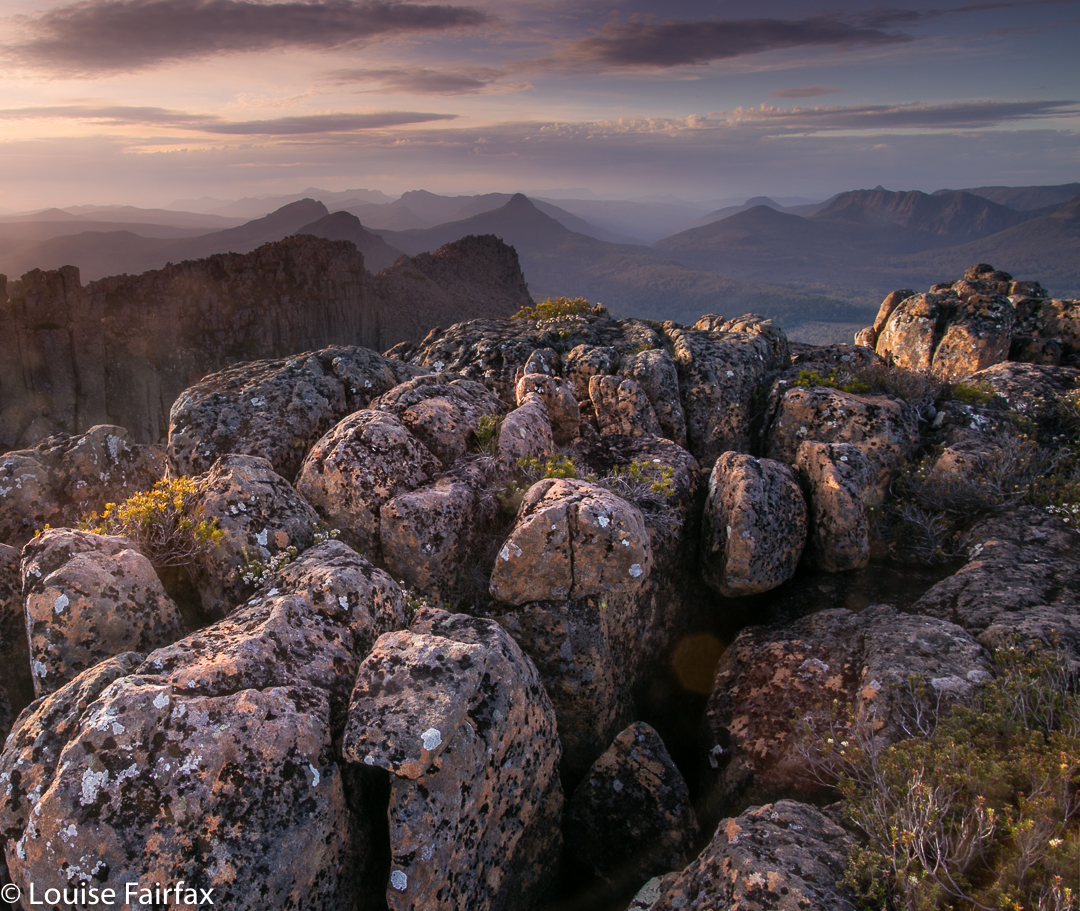
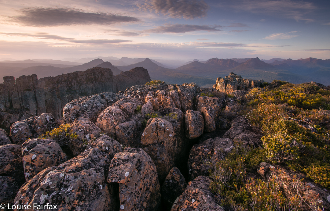
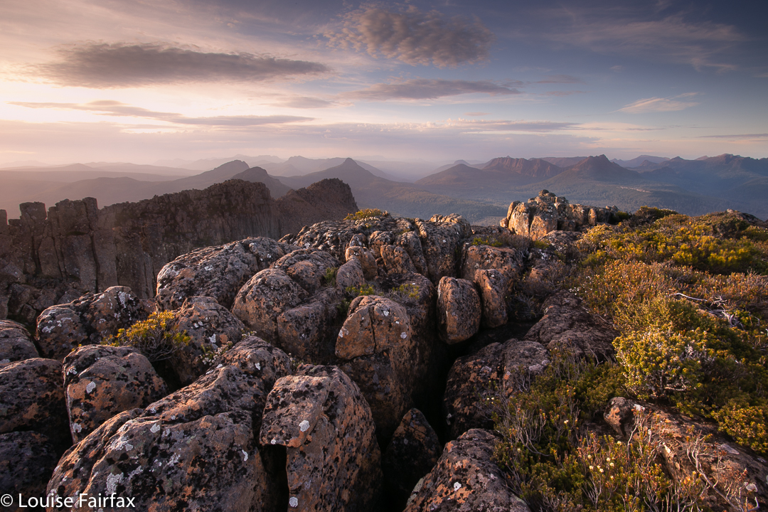
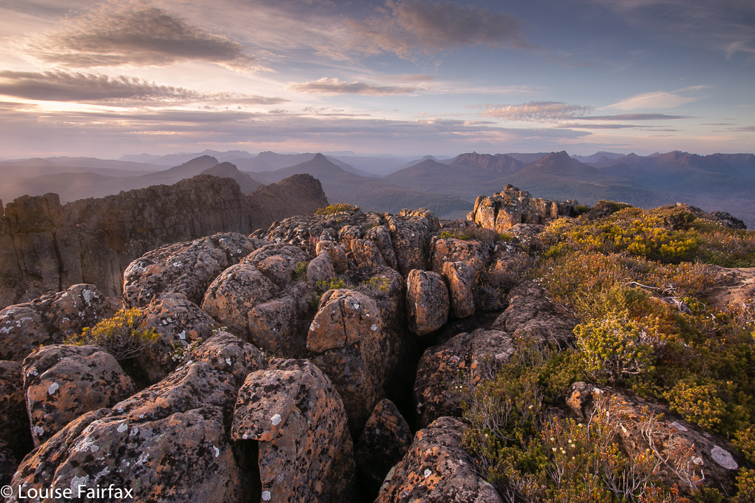
Leeawuleena spread out before us Mt Othrys has one of my favourite summits. Leeawuleena (Isn’t that the prettiest name imaginable? It is the Aboriginal moniker for what white people labelled Lake St Clair, and means Sleeping Water) sparkles below, and the broken dolerite pillars jut and thrust their way in odd but attractive directions, making for a jagged and interesting framing of the scene and a dragon-spine skyline.
Blue and green should always be seen
I could have spent an hour up there, or more, but will have to do that next time. On this occasion, we were in a hurry. Angela had been on call, so we could only begin our exploits at 11 a.m., and she needed us to keep to the book’s estimated 7 hours for the climb. That sounds like plenty of time for a 25 km equivalent exercise, and it was – just – but only by keeping up a pretty smart pace throughout the day, and allocating a mere 25 minutes for lunch and photographs at the top, for, you see, this beauty is rather inhospitable to visitors, and the mountain has grown a rather nasty patch of protection to prevent all but the most handsome of princes from entering. We are neither handsome nor princes, but did manage to find a way through. Othrys has a bad reputation amongst bush gossipers, and for quite a good reason.
We lost a bit of time on the way there trying to find the track amongst the button grass plains, but as we figured this was faster than making our own way, persisted in searching for it. We left the pad at a rock with a cairn on top, which fell a bit short of my intended point where the summit-to-path projected line intersected perpendicularly with the path. To put us back on the route I wanted, we headed for a waypoint I had made on this imaginary line, and found an excellent route through the melaleuca scrub hugging the creek at this point. Our route through the forest for at least half the journey was also relatively easy, much better than reputation has it. However, in the upper reaches we struck a band of young, dense melaleucas that left me exhausted by the time they’d finished their sport with me, but we did win through, and from that point, headed straight up rocks for the summit, which was reached without much difficulty.
Different view of Olympus
On the descent, we were able to stay on the rocky nose for longer, it now being visible from above, and had a trip down that was an hour faster than the ascent of four hours.
Summit dragon spine
Unfortunately I cannot give you my normal jpeg version of the screen image of our route, as about 200ms from the top I checked the gps to see how we were going, and undid “screen lock” and then bumped something (I know not what), with the result that my machine stopped recording, not only for the route up, but also refused to cooperate on the way down. It wouldn’t even show me my gps position. This morning it seems in better health, so I have no idea what I did, but there is no track for the remainder of our climb, or for our good descent route, alas.
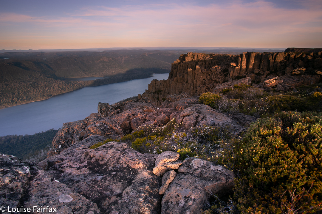
Should this interest you: The mountain offers a fascinating angle on Mt Olympus and the shapely Mt Ida is directly opposite. In the distance lie many other mountain friends from this much-loved region, while directly below to the other side, the Cuvier Valley spreads out for display, with Lake Petrarch adding more blue sparkle to the scene. Particularly interesting for Angela and me, as we had climbed there only a week before, was a new perspective on Hugel and Little Hugel, with the Cheyne Range clearly visible behind. So many loved places visible at once; it was grand.
The Eldons: High Dome, Eldon Bluff, Eldon Crag, Dome Hill, Castle Mountain, Rocky Hill Jan 2016.
This was my first really big epic; we had packed for ten days, and I was pretty nervous. Could I carry all that weight? Ten days seemed a very long time to be bushwalking in the wilderness.
Day 1. Here we are, heading across the clear Rocky Hill South towards our destination for the day: Rocky Hill campsite. All is going well and everyone is coping perfectly with the heavy load that a trip like this entails. I was carrying 17.5 kgs, which is between a third and a half my bodyweight. I was intending to do some very serious eating to improve that ratio by the way out.
Day 1. Many of us camped near or under beautiful pencil pines like this. Pineapple grass was in abundance, as were delightful pools of clear water. These were especially welcome after a completely water-free day once we left the Collingwood River right at the start.
Day 2 dawned misty. Here is the group as it heads along the ridgeline connecting Rocky Hill to a hill at 1173 ms asl.
Day 2. And here is our final resting place for this day: the beautiful Five Duck (yet duckless) Tarn. It was very exciting to be so near a mountain that has always looked so distant and impossible, a mountain for tough bushmen, so not for me, yet here I am: High Dome.
Day 3 dawned clear and bright. We set off early so as not to be cooked later.
Day 3. And here is what it’s like to be underway in the Eldons. These are button grass plains which formed patches to give us a break from the thicker scrub of other sections.
Day 3. A very happy summit group on top of High Dome. On the far right is Malcolm Waterston, the sixth person ever to complete a full set of Abels (which he finished this trip).
Day 3. With High Dome under our belt, on we press to our next destination, Lake Ewart. On the left is Castle Mountain, and on the right is Eldon Bluff, the crème de la crème for many of us on the trip.
Day 3. Dan and Steve were two of many who used our early arrival at the lake to have a swim and a wash. Unfortunately, wuss here was too cold, but she admired the waters and went exploring around the lake’s edge instead, discovering a grove of scoparia whose leaves were well above her head. That’s scoparia at its best!!
Day 3. With the sun setting behind Eldon Bluff, many beautiful silhouetted moments were on offer.
Day 4. At last, the day to summit the Crown Jewel of the trip has arrived. Here she is smiling pinkly down on us while we wipe the white frosted icing sugar off our tents and fill our packs with enough water to fund a mid-thirties temperature day. I took this photo whilst eating breakfast inside my tent (ie, I pitched so close to the water’s edge the others teased me that I’d get flooded out if things went badly).
Day 4. The beauty of the lake in the early light as we circled it thrilled me.
Day 4. Round the northern end of the lake, over the buttongrass plain and up to this rock that we spotted from below. We had to climb a tree to get up it, which was fun. It made a good perch for a rest, and also to survey the beauty of the surrounding landscape.
Day 4. Happy climbers taking a rest on a different rock. Time for breakfast number two (about 8.30).
Day 4. Looking across to Eldon Crag (the next one to be climbed after this) whilst having a break during the climb of Eldon Bluff (up to our left).
Day 4. The group arrives at the saddle before the final climb. You can see we’ve already climbed up a very long way.
Day 4. I saw this view just before we reached the summit, and was terribly excited. There is Lake Ewart, way, way below, and I could even see my trusty tent waiting for me by the water’s edge, a minuscule red speck. The day was very hot, and people drank even more than the generous amounts they had catered for (one guy went through 8 litres in total). After we climbed this mountain and the next one (Eldon Crag), we dropped slightly out of our way to a tarn about half way down to Lake Dorothy to cool down and gather more liquid.
Day 4 draws to a close. It had been long and hot, but we were all deeply satisfied. This almost dry creek made a fabulous “highway” for part of our descent. There were even protected native fish in one of the rock pools. The water was cool and delicious. Money cannot buy drinks like that.
Day 5. Another day, another mountain, more perfection in the wilderness. Today we will climb Dome Hill. Ahead, you can see the first part of our climb. Because of the heat (and our ultimate goals for the day), another early start is chosen.
Day 5. About 1 hr 30’s walking later, we get to see epacris serpyllifolia adorning the summit of Dome Hill, with yesterday’s booty, Eldon Bluff and Crag, in the background.
Day 5. Dome Hill summit group. After this, it was back to camp, depitch and climb up through the scrub onto the plateau that contains tarns that will give us a good springboard the following day for the next mountain on our agenda.
Day 6. Sunrise from our tarns
Day 6. Two of our group approaching the summit of Castle Mountain. The weather did not cooperate with a view from this summit, but I found the mist atmospheric.
Day 7. Dawn from High Dome ridge (a dry camp – i.e., no available water nearby).
Day 7. Morning light on a day that was pretty light on for those of us who had already climbed High Dome on the way in. Lucky we were just loafing around camp, actually, as the wind came up mid-morning. One tent snapped its pole in two places, and the three of us there had to lie on tents and depitch them to prevent further breakages. That day we moved to Five Duck Tarn, where, in the evening, those who didn’t mind being out in the weather got to watch lightning strike the ridge running off Little Sugarloaf, setting off a blaze the height of two gumtrees, clearly visible from our spot.
Day 8. No photos, as it was pouring with rain and blowing a gale most of the day. We decided to put in a huge effort and get out. You could smell many of the 50 fires that were now burning across the state’s lower half, and today was an ideal day for a big effort, being both cold and wet. Warm, dry weather would resume the next day. Who knows what the fires would do then? Pyramid Mt was cancelled; the guys had never been keen on Camp Hill. We had reached the next destination by lunchtime (Rocky Hill campsite), having climbed Rocky Hill in conditions so freezing that not a photo got taken, and all voted to walk two days in one, and clear out rather than sitting in sodden tents for no good reason, waiting for the next day. Dinner that night in the Derwent Bridge Pub was a very happy affair. Celebration was in order, and the huge open fire was maybe even better than the hot, non-dehydrated food.
I was still an undergraduate when I had my first glimpse of Mt Olympus while doing the Overland Track with my husband. It was love at first sight: it looked so impressive and imposing perched up there above Lake St Clair. “What a view it must have from the top,” I thought to myself.
Time went by; we finished our degrees, had children and moved to Tasmania. And one of the first things we did with our daughters in their new state was to walk the Overland Track. I have a photo of them excitedly running in the direction of Mt Olympus (they seemed to finish every day running with excitement. They were aged 6 and 8 and adored the trail). Each time I have done the track (6 so far), or been in the area, I have wondered about the view from the summit, and have wanted to sleep up there. Last weekend I got my wish.
Maybe three-quarters of the way up Lamonts Lookout
Day 1 was hot, and I love being warm. I was anticipating another wonderful balmy night on our summit. To be on top of a Tasmanian mountain in mild conditions is one of life’s supreme treats: gazing out at the foison of indigo peaks set against the evening sky, whatever its colour that night: peace, sublimity, vastness and wonder. Rest for my soul.
We caught the ferry down the sparkling lake, and began our climb to Byron Gap, along the pad that leads through the fabulous rainforest. All the creeks were running and we drank plentifully from their cool, refreshing waters before popping out at the Gap itself, where we had lunch gazing at the seemingly ubiquitous Frenchman and his beret.
Paul resting amongst the rocks on the final climb
Now it was time to depart the quasi-track and climb steeply through the obligatory band of scrub, complete with scoparia that was sparingly in flower, but the red of which gave a quite Christmassy feel to the scene, and on, higher, to Lamonts Lookout, a rocky perch with a grand view. More rocks, more traversing, a bit more climbing and there at last was the summit cairn. The wind picked up mildly as we breasted the final rise, but nothing to cause concern.
Sunset from Mt Olympus
We dropped a few metres to the verdant green spread below and chose our spots – a tarn or two to each person, right at the tent door if we wished, and views to dream about. I chose an angle that included a gaze that embraced most of the mountains I love from the Overland Track region. I could discern everything from Pelion West south. Heaps of friends there! Over dinner, Paul recounted a time when someone once asked him: “What mountain is that?”, to which his reply was: “I don’t know, but I’ve climbed it.” (He has climbed every Abel and every mountain worth a point on the peak baggers’ list.) I have not climbed as many peaks as he has, but have amassed enough to understand how it must feel, as when I look at the skyline these days, it full of mountains whose moods and intimacies I know. I have climbed every Wainwright in England, so I do know how satisfying completion feels.
I photographed the sunset out on a perch, my tripod anchored. It was a bit breezy, but nothing to make life tricky. Our tents flapped rather noisily, but nothing in our purview bespoke danger. No one suggested retreating, although everyone agreed we could be in for a noisy night until the wind abated. Far from receding as predicted, however, the wind intensified as the night progressed, constantly changing direction, and often making the fabric crack like a whip as it lashed in a new tack. I had tightened everything before turning in, but by midnight, had to get up and redo each peg and guy rope.
Sunset from Mt Olympus
At 2 a.m., the lashing was so violent I had to get my head torch and go outside to examine what was happening. The fly had filled with air like a spinnaker, and had lifted the pegs out of the ground. They had been hurled into space and were not to be found. I tried to find rocks to provide stabilising anchors, but the wind made mincemeat of that. As fast as I attached a loop to a rock, the wind just filled the fly and it rose, tossing off its rock as if it were a ping pong ball (although they were rugby rocks). I placed the few pegs that were left into key positions and retreated.
Sunset from Mt Olympus
Unfortunately, this needed repeating at quarter-hourly intervals, from then until nearly 3.20, when conditions changed. By this time I had lost an absurd number of pegs, and rain now started. The wind intensified even further. The fly flapped and banged, a wild thing; I was lifted from the ground with each gust as my moorings were gone. I wondered if I was about to end my days being blown over the cliffs of Olympus in my tent. I also thought about how wet I and my sleeping bag were about to get. I am highly susceptible to hypothermia, so was entering dangerous territory. How long do you leave it before you cry for help when doing so is going to greatly inconvenience someone else? I lay there.
Tents on top.
3.40 was crunch time. There was an almighty crack as the wind twisted and broke one of my pole sections and drastically rearranged another, thrusting it through the fabric. Now what was left of the tent crashed against my face. Only the guy ropes prevented the Great Escape. I was about to get soaked. Time to exit. Still I was reluctant to disturb anyone else, so circled the others’ tents, wondering which one to use as my new harbour. The Microlights’ vestibules were full, I could see, but the Hilleberg looked as if it had room. Rohan was sleeping, I assumed. I didn’t want to wake him and didn’t want to impose, so circled some more, finding his gaiters that the wind had stolen and transferred to the nearest tarn. I fished them out. Rain strengthened. I was going to wet my only clothes if I continued this vacillation. Reluctantly, I called him to ask if I could sleep in his vestibule. Permission granted, so in I climbed and, exhausted, fell asleep on the ground. However, I was only wearing my light orienteering gear with a jacket on top, so soon woke up, cold. Rohan kindly leant me first his overpants and then his bed socks. Once more I drifted off. Later, he realised I’d be warmer if I came in, so I accepted that offer, too, with gratitude.
Packing up next morning was a huge challenge. I had to dive under the still manic fly to pull any of my strewn belongings out from inside the tent. I had to stand or kneel on anything extracted, which made getting the next lot tricky, and several times I lost my grip, to end up chasing flying gaiters, socks and more. Even one boot ran off. I needed a dozen more arms to do this job. The others all had the luxury of packing up inside their fly and only emerging at the end for the tent-dismantling stage, but all my rumpus was being conducted al fresco, and with a minimum of style or success. I was still fighting my belongings and the others were obviously ready, waiting for me. I hadn’t even eaten. Being prone to hypoglycaemia as well as hypothermia, I couldn’t take off without any food. There was no point. I would quite literally faint on them within a half hour. My compromise was to have a muesli bar and a glug of water – not nearly enough for a person who normally has a super-giant bowl of muesli and a couple of bread rolls (and three cappuccinos) for breakfast. I am like one of those old cars you have to fill up at every town. No doubt quite annoying. This spelled trouble. Within half an hour I was sporting a headache; I was mildly dizzy and uncoordinated all morning.
Normally a happy rockhopper – called by others a gazelle – today I was a clumsy oaf. Not only was I clutching tenuously to consciousness, I was being blown sidewards by the gusts of wind. My reaction time was slow and I didn’t dare leap or practise my tightrope technique on the edge of rocks. I was cautious in extremis, which made me very slow, but eventually I made it over all the boulders to the other, second and slightly lower southern summit of Olympus and a different kind of view.
The rest of the day is a blur. I can tell you we exited by the unloved Cuvier Valley. The way was long and it hurt. Mostly, I was plodding along trying to last to the end in the face of increasing pain, which had now set in rather badly. I also felt defeated, which did not engender great brio. Somewhere near the end it seemed that the track had disappeared. Every way was the wrong way. I was almost delirious with pain and could not see clearly, either literally or metaphorically. Thinking was beyond me. I no longer cared what happened. I was executing a plan (slowly, in an almost oneiric trance) when I heard Angela’s voice, sounding distressed. I called back and headed towards her. She was worried about me. The only warming thing that happened to me on this day was her obvious pleasure and relief at seeing me safe.
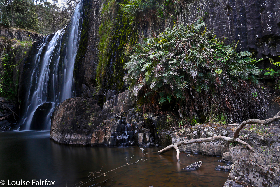
The Guide Falls are only a short distance from Burnie. Head south on the B18 towards Ridgley, after which you’ll see a clear sign pointing you in the right direction (initially, on the C104). These Falls were delightful, although I hated seeing the old-fashioned wire and steel railing to keep me from falling off the edge.
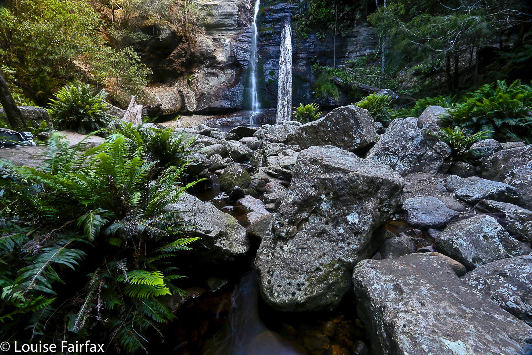
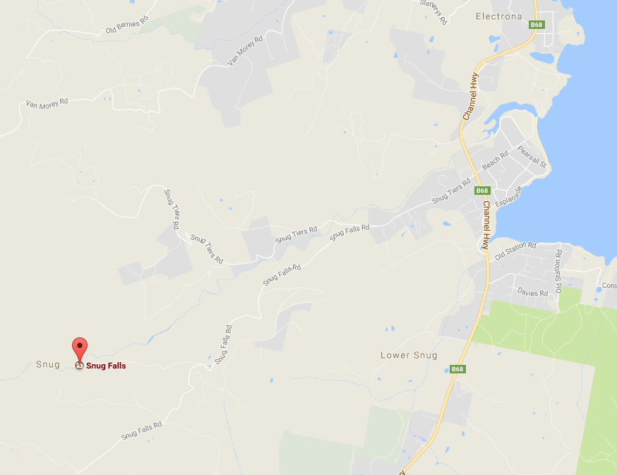
To reach Snug Falls, follow the Channel Highway, (B68) south from Hobart until the village of Snug. Just after it, turn wettish onto Snug Tiers Rd, and then fork left onto Snug Falls Rd. Signs will direct you to the parking area, from which it is a 2.1 km clear walk on a track to the falls.