Reeds Peak, Bonds Craig, Lake Rhona

It was “third time lucky” for my desire to climb Reeds Peak and Bonds Craig, and to see the famous Lake Rhona.
The first time I tried, which I was going to do with my daughter, the weather was so foul that as we drove west and eyed up the torrential rain, we opted to stay that night at Strathgordon Lodge instead and to just have a single night on top of Mt Sprent as a substitute for the longer undertaking.
My second attempt was a solo one, but I was turned around because of the aborning bushfires. I spent that night on Tim Shea, watching on helplessly whilst huge tracts of land that I love fell under the doom of flame. The scorches were still in evidence this trip, and my face was black when I came out of the bush.

Rhona beach on arrival = pretty excited.

And here I was for attempt number three, once more with my daughter. It looked as if this trip would yield a similar fate to that of the first two attempts: the forecast was for gale force winds, snow and temperatures of a MAX of minus one by day and a minimum of minus four overnight. Of course, with the wind-chill factor, those temperatures would be even colder. Recipe for a glorious three days, huh? I wasn’t even sure if we would get over the Gordon River, which you have to cross using a fallen log. If the log was icy and slippery, we would not get far towards our goal. I had a few “Plan B”s in my head, just in case.

Arriving at Lake Rhona. Can you see the snow falling?

I was certainly not going to let myself get one bit excited about this trip before I inspected the river and the log, which is only about 30 minutes from the car. As it came into sight, we could see that the river was quite swollen, and only had about 10cms to go before it would cover the log and make it dangerous. But right now, we could cross, and in safety, so that we did, with me crossing twice: once with my rucksack, and once with my camera, just in case I met with catastrophe. If I fell in, I didn’t want to be taking care of too many things at once.

Poor boots

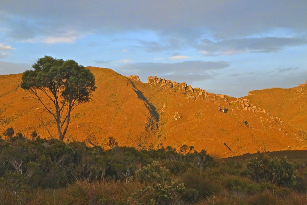
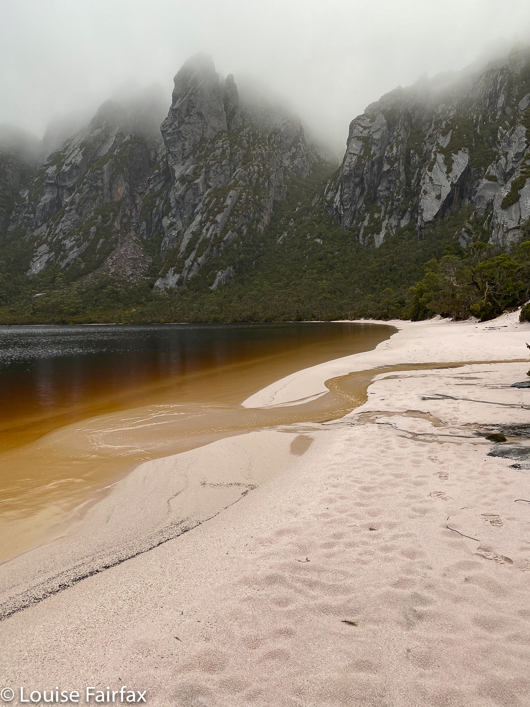
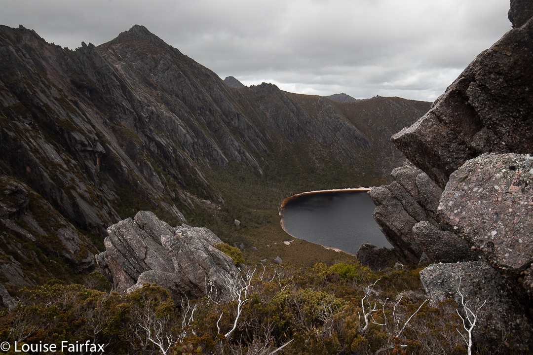
Over the other side, the former forest was very charred, but as we wended our way further towards Gordonvale, the amount of green increased. Signs of fire, however, stayed with us right up to, and including, the lake. There was a definite line visible from the lake where someone had paid to have sprinklers put in to protect his precious Lake Rhona. Thank you, whoever you are, for helping protect our magnificent wilderness from ravages brought about by climate change and humans’ selfish interference with the environment.
Rain began soon after we crossed the river: light at first, but with increasing determination. Kirsten called it “quietly achieving rain” – the achievement being to get us soaked, I assume. It was also successful in making me clumsy, as I had my big camera, gps and phone, all of which now needed to be transferred to drysacks, to be then tucked under my anorak before the pack straps got buckled. I made the Michelin man look skinny.

Rhona on the morning of day 2

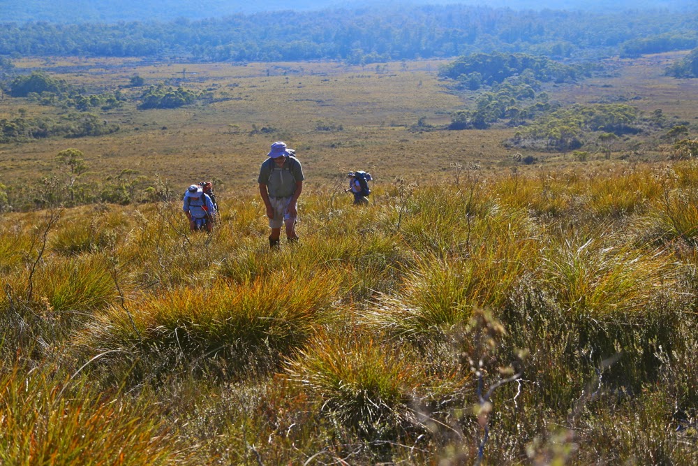
There were many creeks after Gordonvale, normally nothing noticeable, but today they were raging, of unknown depth, and not offering any easy places to cross. Partly because of my electronic gear, and possibly also because I was still tired having only just finished my Geryon trip, I didn’t feel strong enough to trust my footing in water like that, so went up and down the banks of each creek looking for a place where I could be guaranteed to cross without mishap. The actual crossing of each one was slowly and carefully done, using sticks for stability. The rocks were slippery and the water strong. People and cameras stayed fine.

Climbing Reeds Peak on the afternoon of day 2

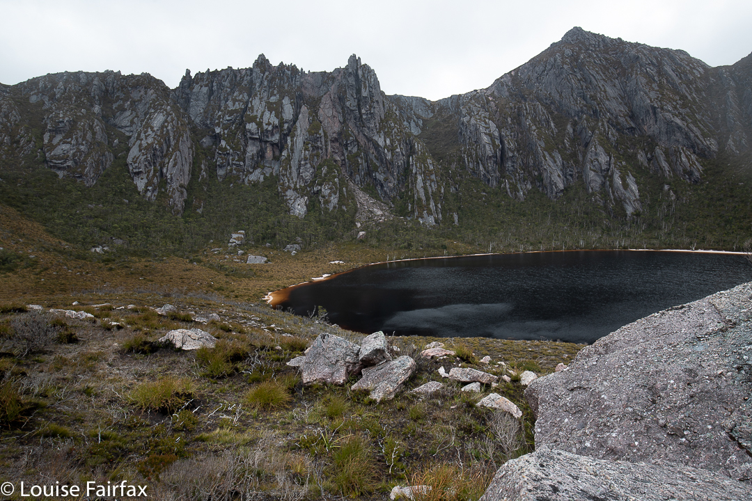
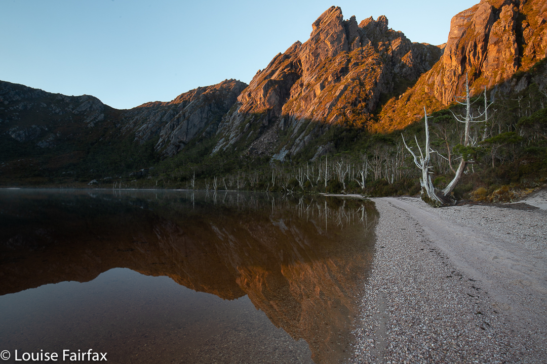
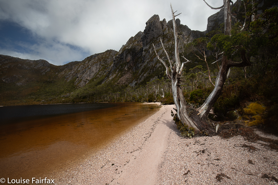
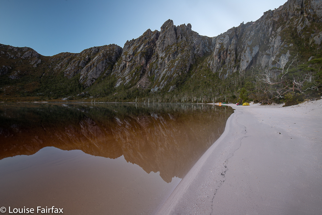
And so, inch by inch with the weary load, and by the power of the luring goad, the distant goal was won. Yes, we two kept moving on … and finally up, until, at last, we peeped over the edge of a small rising and there was the famous Lake Rhona; no mistaking it. Photo time for sure, although I later threw these ones out. They were mere photos of excitement.
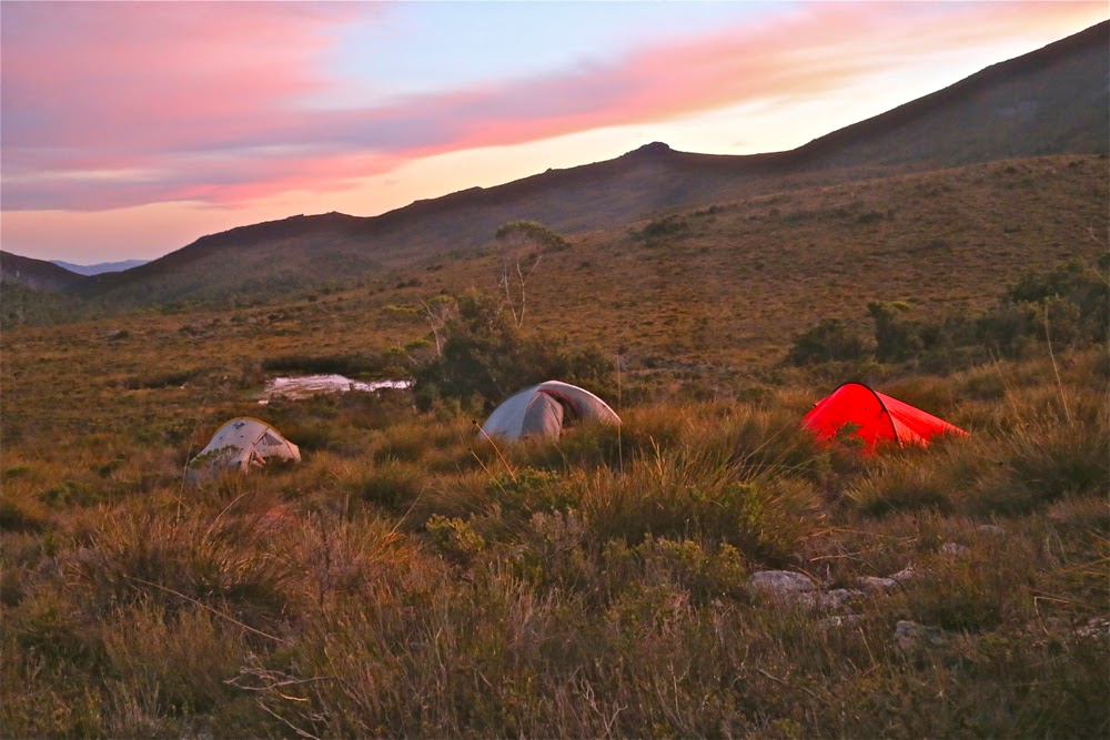
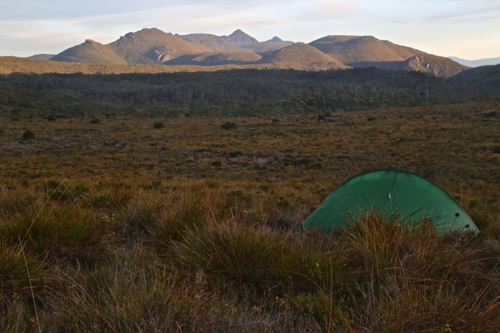
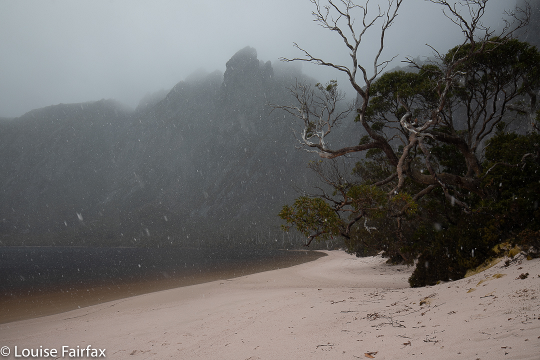
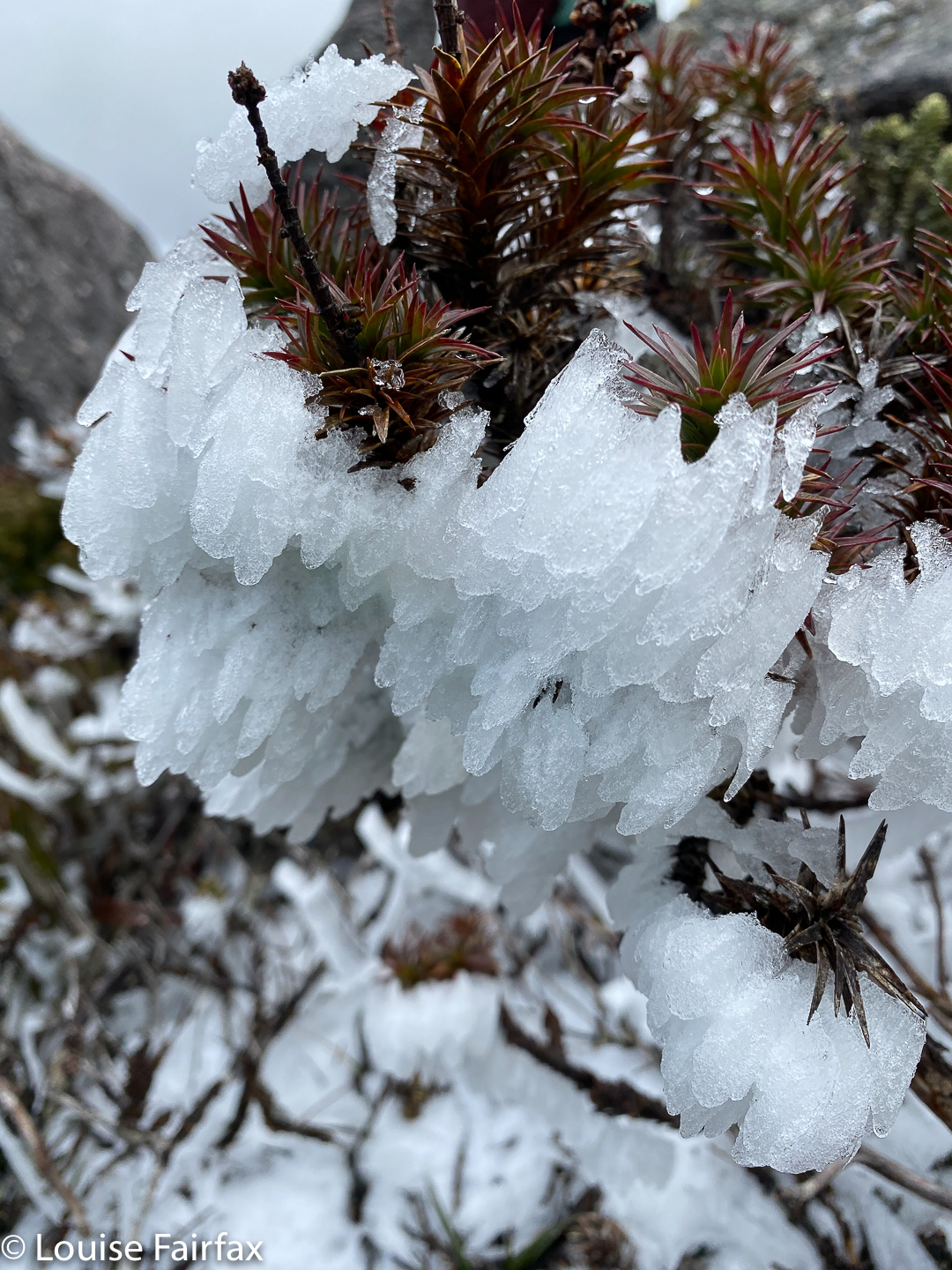
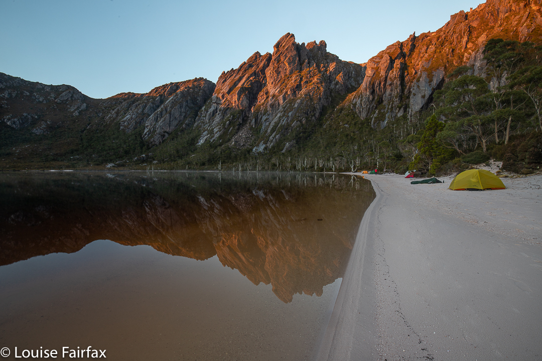
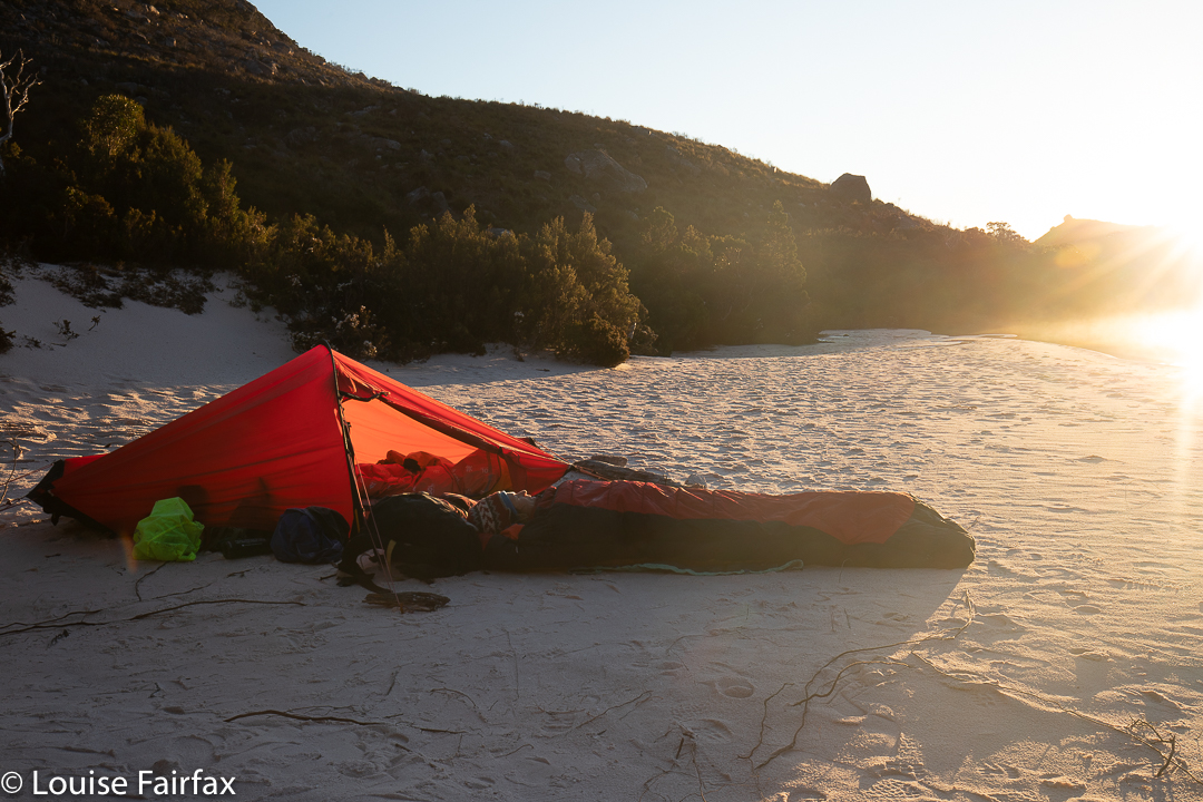
In the bowl-shaped depression of the lake, there was shelter from the blast, which had been spearing us with icicles for quite a while. Now, it was “just” snowing with gentle, fat flakes, and the wind could be heard higher up, but it was not buffeting us where we were. Nonetheless, we chose our spot carefully, as we would be pitching on sand, so the pegs wouldn’t stand for too much force.

Climbing Reeds Peak on the afternoon of day 2

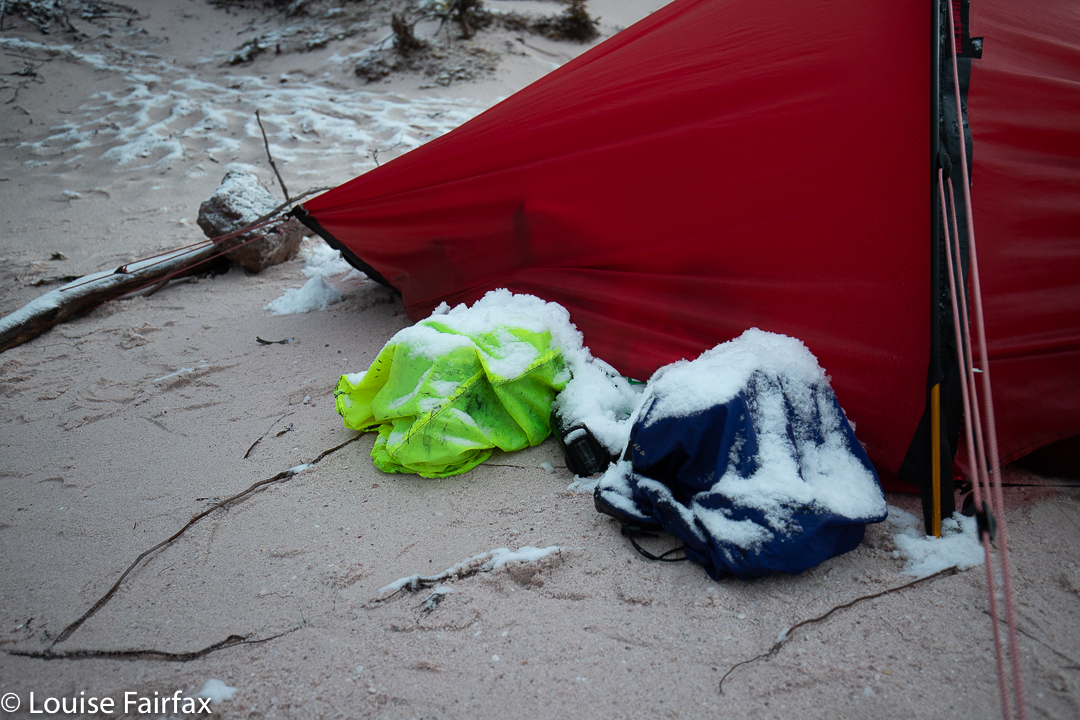
It was squashy with two in a solo tent, but at least it’s a Hilleberg, so pretty spacious for one. Our packs went in the vestibule after dinner, and our poor shoes got relegated to the outside world to be covered in snow during the night. (We popped a pack cover over them). Luckily no one needed the toilet during the night.
Morning, however, meant we did have to use said questionable “facility”, which was no easy matter. (For non-Taswegians who don’t know these things, there is no roof over your head). The lid on the seat was covered in a 3cm-thick layer of solid ice. Turning the knob to undo the lid was out of the question. Kirsten discovered she could lift the entire toilet off its hinges, so moved it away in order to access the hole. I later had to do the same, and thought whilst squatting in the snow over a small hole with wind blowing the flakes around my face and the toilet itself upended behind me, that the situation was possibly not to everyone’s liking.

Getting higher

It snowed on and off all morning, teasing us. Each time we thought it had cleared and went for a tiny walk along the beach preparatory to packing for the climb we wanted to do, the snow and wind freshened their efforts. At about 11.30, I said I wanted to do a proper walk anyway; these bits of walks weren’t doing it for me, and I knew Kirsten would be in total agreement, so we went back, ate an early lunch and at about 12.30 set out upwards, with no special goal other than having some exercise in mind. BUT, we were, of course, setting off in the direction of Reeds Peak. Should the weather improve, then we’d be ready for the climb.

Nearly on the summit Reeds Peak

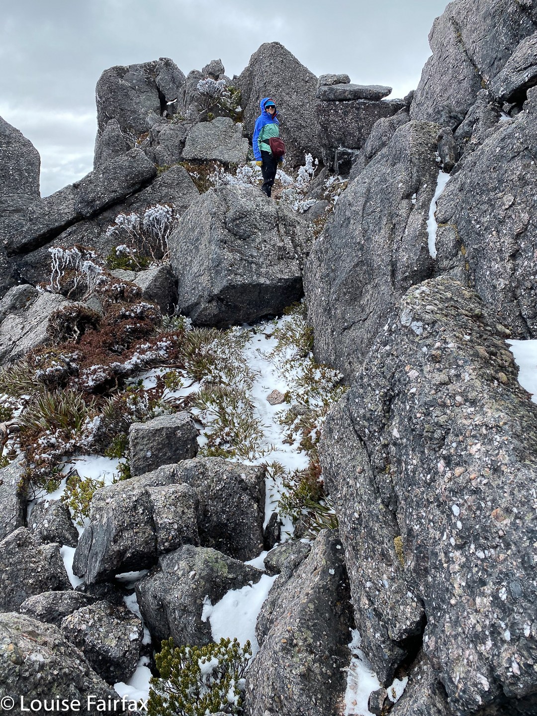
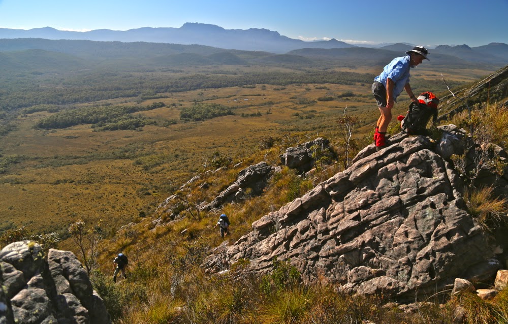
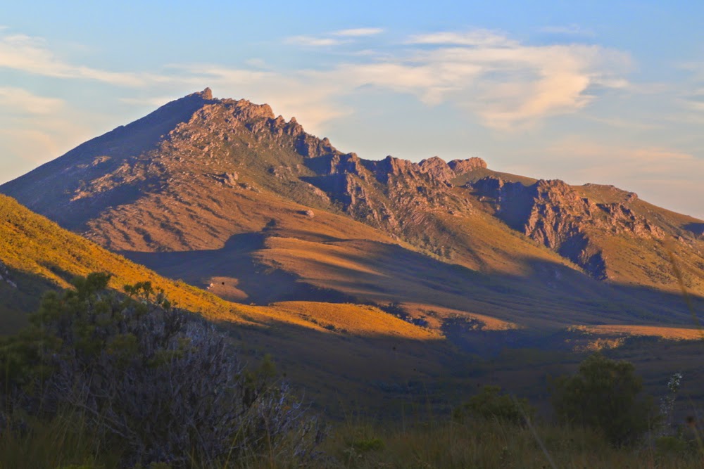
It was still snowing as we summitted, but only lightly. What made the final ascent dangerous was not the snow, or the wind, but the thick rime coating the rocks, making them very slippery indeed. I was not one scrap comfortable up there. I touched and said I wanted to go down straight away. I would not relax before we got out of the rocks and back onto the grassy ledge at the base of the final climb.

Reeds Peak summit. Two steps to go

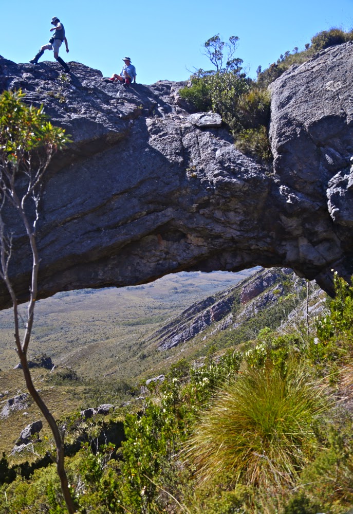
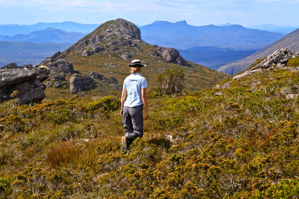
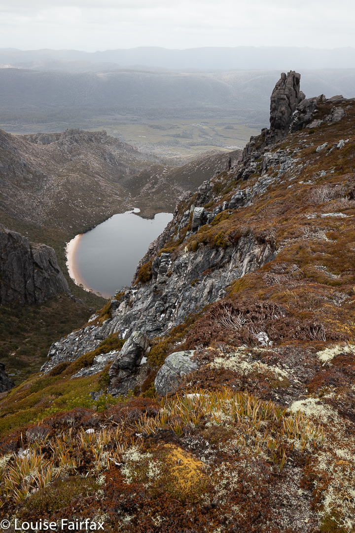
On the way down, we noticed a kind of lead which Kirsten felt compelled to examine. It was kind of a back door entrance to the mountain which would have made a much easier climb than the one we had just done, and now made an excellent route for the descent. It was heading in the direction of Bonds Craig. I was not one bit committed to this mountain, but we both wanted more exercise than we’d had so far (only 1.5 hrs at this stage), so off we set.

Reeds Peak icy vegetation

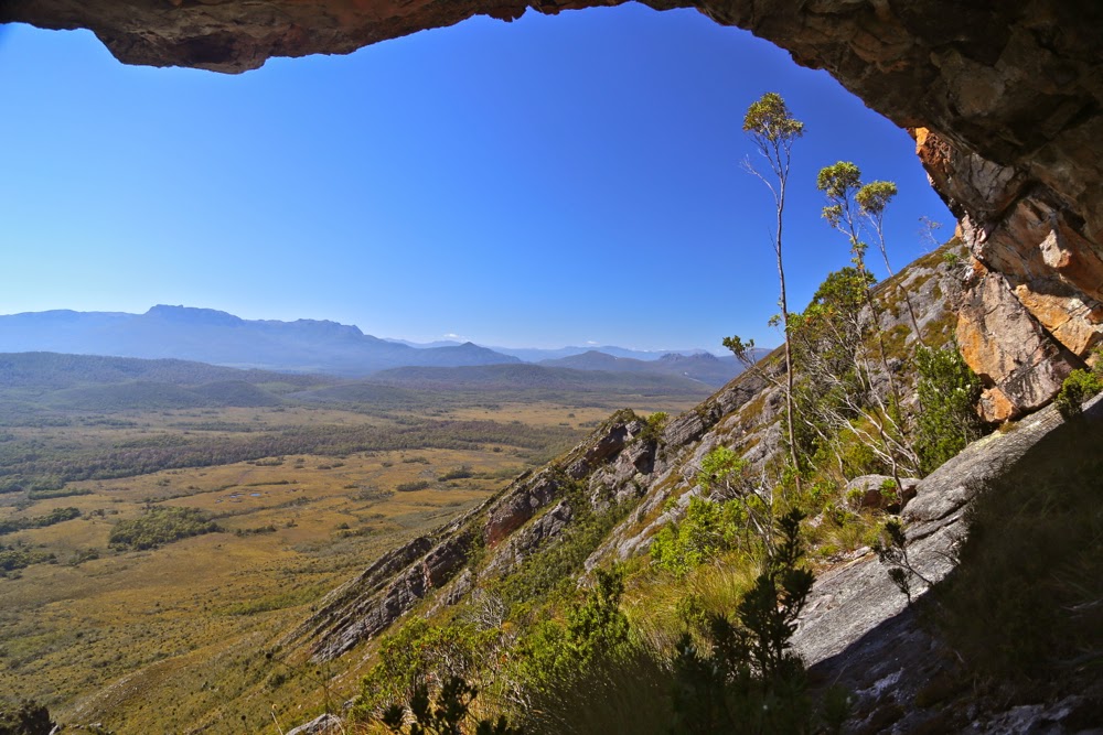
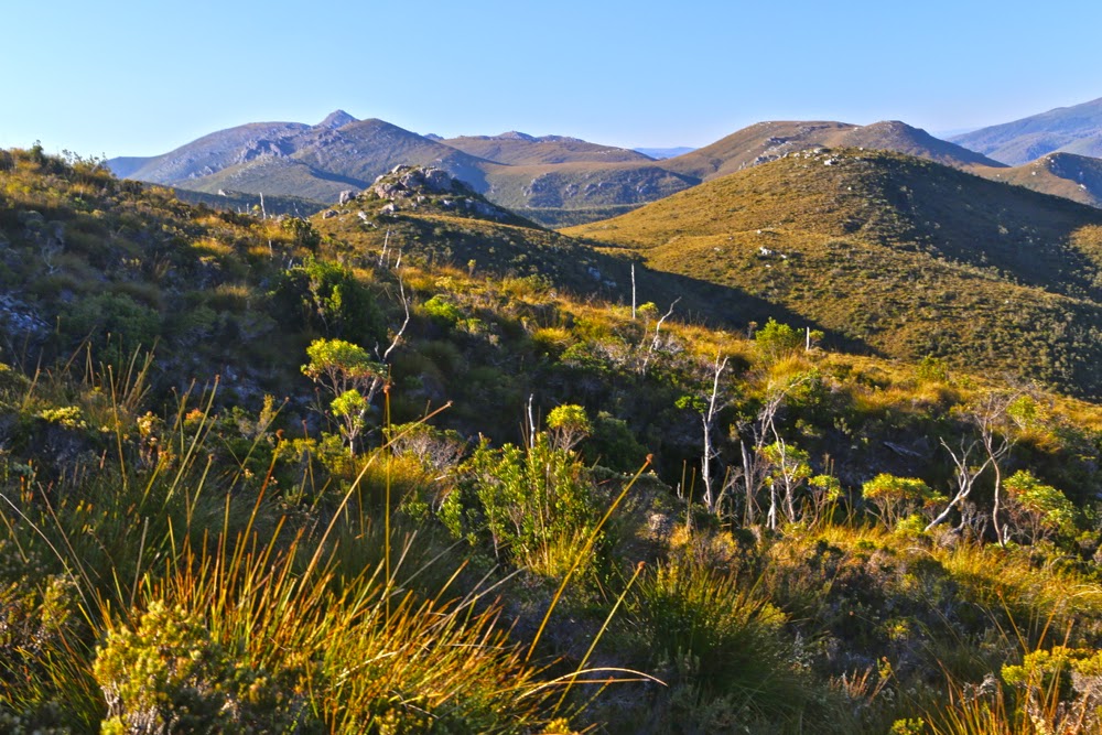
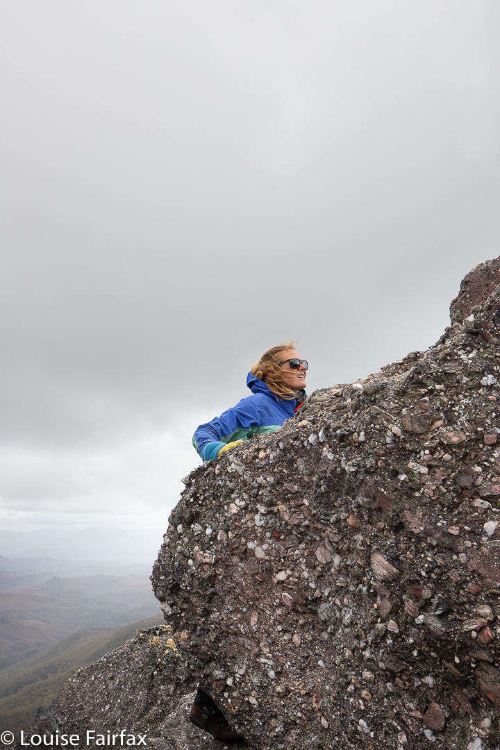
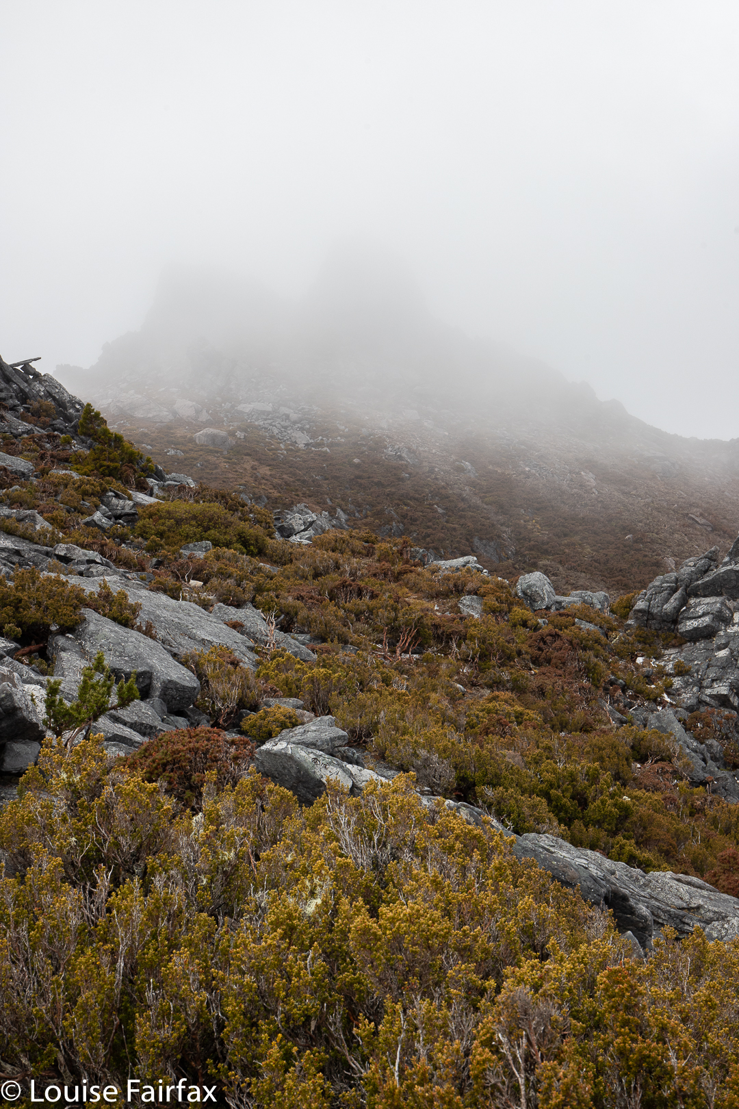
The terrain is beautiful up high, with moist alpine meadows. The section between Reeds and Bonds was less fertile, but we still enjoyed it, although the wind was starting to get at me. Bonds Craig was nothing more than a slightly darker shadow in the thick mist, but we strode purposefully towards it. We’d at least inspect the base and initial climb. It gained in form as we drew nearer. It even stopped snowing for a bit. Once faced with the beasty itself, we both felt fine about summitting, even though it was very misty on top, with no views to speak of. The small area in between the summit rock and a false summit offered some protection.

Bonds Craig ahead

Be that as it may, however, I wanted a proper rest out of the wind, so not long into our return journey, we dropped over the edge to a sheltered area at the top of the steep but leeward side, and had a snack. The book had said it was feasible to take a short and steep route back to Rhona, but we had really enjoyed being up high and feeling the space and seeing the views and the alpine vegetation and were in no particular hurry to sit in the tent again, so we voted for returning the way we’d come and enjoying the experience of the ascent in reverse. Somewhere and when in there, the snow stopped and the wind began to abate.

Pre-dawn light, day 3

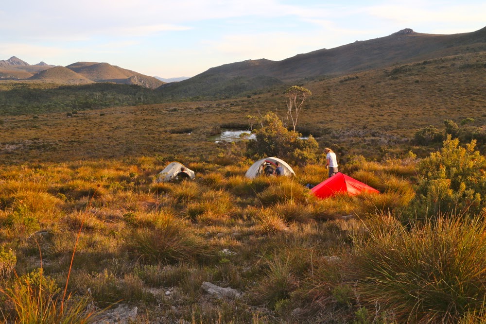
The next morning, the skies were so clear Kirsten muttered from the comfort of her sleeping bag about a swim. She announced once she’d been outside that perhaps she needed to rethink this matter. Meanwhile, we had the important job of photographing the dawn, and meeting some of the people who’d arrived while we were having dinner the night before, camped at the far end of the beach.

Rhona Sunrise

By 11 am, the swim became a reality. We were not in a rush, as the newcomers brought with them the news that the river was now over the log. If we delayed a bit, it might decrease sufficiently to let us back over. By 5 pm, it had gone down enough to kind of let us across … crawling for safety. Not for the first time this trip, my daughter took the camera for me. She does some pretty scary stuff holding her kids, so I trust her with my camera far more than I trust myself. The log was very slippery indeed. Ever crawled in 25 cms of water on a log over a strong, wide river? Such fun. We are both strong swimmers, but if you go in the drink over your head, you must release the pack, and you might never see it again if you do that. That knowledge adds pressure.

“Warming up” in the sun before having a swim

Also, I have never swum in bushwalking boots, and was not keen for a first experience of that one, either.
But having successfully crossed the danger, Kirsten then stripped off and had a quick swim in a protected backwater …. just ’cause it’s the famous Gordon River, just ’cause it’s the wilderness … just ’cause she could. Isn’t that sort of thing part of what being in the wilderness is all about? I have pictures of this daughter swimming with icebergs. There is a lot of her beloved dad in her. :-).  Her mum’s a wuss.

(If you are not experienced in these matters, please note that before you ever begin crossing a deep river, you must release all buckles, as if you are submerged, they will probably be pretty impossible to undo, and you will drown if you don’t. Undoing buckles is not the first thing people think of, but it is essential.)

Stepped Hills 2015 ii Nov

Stepped Hills 2015 Nov.

The first hurdle between us and our quest: Mt Wright from down below
I looked ahead at the mossy rock on another rock, and could, for the moment, see no other higher ground. Could this be? Dare I hope? I called to Mark directly behind me (It was my turn to lead):
“Mark, I don’t want to make assumptions, but …”
“I’m making the same assumptions, Louise, but I don’t want to name them, just in case.”
“We’re running out of higher ground possibilities.”

The mossy rock posing as a cairn seemed almost an anticlimax. But there was nothing else on the mountain higher than we were at that moment. This was it. We’d reached another summit.

A tranquil patch of the Gordon River

Excitedly, we gave each other a congratulations hug and together ceremoniously touched the rock. It had felt like hard work, involving a double climb as the most popular route to reach Stepped Hills is by summiting Mt Wright along the way and then losing most of your precious height before embarking on the mount of your quest, and also because we’d only just done a massive effort to summit West Portal a few days before. I had only two days at home in between the two – just enough time to get the mud out of my gear for the next venture. A general lack of water possibly also contributed to the perceived effort: there was no running water in between the Gordon River and the stream that flowed at the base of Stepped – these two separated by four hours fifteen minutes walking with packs, and about eight hundred metres’ climbing and dropping; the day was hot and we were sweating quite a bit.

That mossy rectangular rock there is the best this mountain can do for a summit cairn.

Crossing the Gordon River at the start of the day had been quite tricky: the fallen tree that provides a bridge thanks to one of nature’s more generous accidental acts was wet and covered in moss from the winter moisture (it had rained during the night). It was extremely slippery, and we could see marks where someone had tumbled into the fairly deep river below. Scared by this, I rode it like a horse rather than doing my usual careful walk across. It was a long, fat horse, but I managed. Mark crawled.

The view from the summit in the other direction, looking over Stepped part Two and beyond to Reeds Peak, Bonds Crag and more. The Spires lie over there: a goal for the near future.
The steep climb with mountain in your face over Wright had gone well, apart from surprise and disappointment that the creek normally flowing at this time of year was dry already. We had full waterbottles, but had hoped to have a good drink there so as not to dip into supplies. The “creek” was just an erosion scar now.

The trip down the other side was, as I remembered it from before, perilous due to the array of moving boulders. These rounded rocks do not stack neatly, and were a mobile kitchen-set under our feet: microwave-, refrigerator- and dishwasher-sized rocks (with a few toasters thrown in) all moved underfoot as we placed weight on them.

Mark with his foot on the summit

Down and along we went, stopping about half way between the two mountains near a tarn to pitch our tents and have some lunch before we continued. One can drink from the tarn, but Mark had his heart set on running water that lay about a half an hour away, and as I was not good friends with the resident tiger snake that prowls the long grass surrounding the tarn, that suited me well. We had enough water for lunch.

My wonderful room with a view: in this case, of Reeds Peak and Bonds Crag.
Stepped Hills seemed scrubbier than my memory had it, fondly harbouring as I did the idea of a short-grassed uphill stroll. In reality the “grass” was dense, thigh-high tufts of button grass, accompanied by visiting patches of squat melaleucas. Rocky runs gave faster movement. It was steep and kept on going, but was not as steep as Wright. I was just tired from all I have been doing lately. It was not really Stepped Hills’ fault.

We reached the top by early afternoon and, having nothing better to do with our day than sit outside our tents, we elected to sit on the summit instead, so had a very enjoyable hour up there surveying our momentary and hard-one kingdom, eating snacks and drinking the heavenly water that comes from the stream down the bottom. It was lovely to relax up there.

Mark on the summit of Wright, with ten fingers raised to symbolise the ten Abels left to climb for a full collection of 158.

Day Two’s special moment was scheduled to be (and, indeed, was) lunch at the Possum Shed to celebrate, but before we could do that, we needed to climb back up over Mt Wright, touch its summit cairn, go back through its fascinating arch and negotiate the Gordon River (walking this time; the log had dried). I was near Oatlands on the return drive when the predicted afternoon showers materialised. As usual when this happens, I felt smug for missing a dunking.

Wright’s summit rock and its view to the north.
Track data: We walked 23.33 kms and climbed 1700 ms (this is “only” the absolute climb from peak to peak and does not include all the incidental ups and downs along the way. My gps doesn’t measure them, unfortunately). This yields 40 kilometre equivalents – and it felt like it.

Stepped Hills 2015 Feb

Stepped Hills 2015 i Feb. Failed attempt

Up they climb
What is it about some mountains that incites in us a “must climb” response? Is it the shape? The myths and tales that surround it, adding mystery and allure? With regard to Stepped Hills, it is certainly not the name: “Stepped” may well be descriptive, but “hills” is an insult. For me in this case, it was definitely the shape, and the shadows cast on its striated layers the first time I saw it. Perhaps also it was the enormity of the Gordon Gorge that guards its southern flank, announcing the impossibility of approaching from where I stood. I saw it from Clear Hill (also not a hill) and wanted to be there. I saw it when I climbed the Thumbs and wanted to be there. It was always so near and yet so very far with its gulchy uncrossable moat. But here I stood at last with five friends, ready to tackle her despite the forecast of a scorcher. I was full of eager anticipation, although wary of the enormous climb in heat like we had been promised.

A well-deserved pause

Off we set at 7.15 from the carpark. Over the Gordon we went, knowing we’d want a swim at the other end of our journey. At last we were at the business end of things, staring from down in the golden valley up at Mt Wright which guards our goal from the east. First, we had to climb her and descend the other side before we could begin the quest in earnest. Wright belies her ruthless steepness when viewed from the valley below, but I know the reality of her slope and so had kept my pack as light as possible (which did not include forgoing the pleasure I get from having my full-frame camera on board). I was, however, only carrying 600 mls of water at this stage, planning on getting another 600 at the creek I knew we’d cross about an hour from the car. This creek, for me, acts as the start of the business end of the climb – the hand pulling on tufts of grass and bushes, feet at decidedly acute angle to leg, tripping over contour lines type of climb that one engages in on Wright.

Playing at the arch while we wait for the others

Everyone wanted to stop at “table top rock”, but I wanted to check on the creek a tad further up before I had a break: I had been most disconcerted to note a desiccated tarn shortly after leaving the Rasselas track. I said I’d meet the others there. Dismay. The channel of gurgling bouncing waters that had threatened to soak my boots in December was nothing but dust and brown moss today. Oh dear. Mt Wright with a full overnight pack, including tent and stove and fuel, on 600 mls water. Better save my precious drops for later and just watch others drinking right now. I know myself well enough to know that I can survive under these conditions. Please don’t try to copy: I’m a freak. Possibly being a little like a spider helps (minimum torso, long limbs – good surface area for reducing heat, and no fat to insulate it).

View through the arch

Up to the arch we went, with me conserving energy by going nowhere near my aerobic threshold, keeping my heart rate low. The arch provided a welcoming band of strong shade which we would use to have a break in. The heat haze hadn’t developed yet, and the scenery was wonderful and crisp still. Everyone was coping well. Off we set again, this time to the highest point that we would go (5 mins short of the summit) and then down the other side on the rock scree to a point under a rocky knoll that offered the next section of dark shadow for an early lunch. Here I had my first drink – 300 mls. Meanwhile, to our enormous relief we could see two little circles of light far below where we were heading that signified water. Olay.

Beautiful light while climbing Stepped Hills, looking towards the mountains surrounding Lake Rhona.

Now began a challenging descent, made so not only by the brutal gradient, but exacerbated by the fact that the microwave-sized rocks were not stable, and every third one moved under you as you put weight on it, threatening a landslide. I was very tense as I negotiated this peril. Firstly, I had my very expensive camera attached to my chest, and secondly, I have a hand that is still officially broken, but whose protective covering has been reduced. This would not be a good moment to have a fall. When we stopped for a break about half way down, I realised I was stunningly tense, almost shaking, and the relief of relaxing my guard under the filtered shade of the gum trees was bliss. I had another 100 mls of water to celebrate.

Shadows elongate on The Thumbs during our return to camp

At last the dangerous section was over and we now only had to trudge through the long button grass to the tarn we’d seen from above. On the way we discovered a small soak that we could use to pour water over our heads and to quench our thirst. Wonderful. We drank greedily.

Dawn next day

Tents erected (with difficulty, actually. The button grass surrounding the tarn was very lumpy and the shorter grass above was prickly: I feared the bottom of my tent would be pierced, so pitched on pure rock); tiger snake warded off; day packs sorted and we were off with no real rest at all. We didn’t have the luxury of spare time for that. It was, alas, after 4 pm.

Looking back at Stepped Hills shortly after dawn 

Before we could start climbing Stepped Hills, we still had to drop into and cross a creek, so down we plunged, sliding down some interesting cliff lines. At the bottom lay a creek. We could hear running water. Oh joy unbounded. This creek was nothing short of divine. Never, never has water tasted so absolutely, miraculously wonderful, so full of life and so utterly refreshing. It cooled the body and revived the soul. We drank and drank and drank some more. We ditched the tepid tarn goo and drank some more again. The coolness was a magic wand. Now we could climb some more, but alas, the shadows were starting to lengthen, the light was adopting a golden hue.

A whole wilderness to oneself: my little tent in the vastness of the broad ridge

At 6.30 we were still 200 mts from the top. We could easily get there in the light, but the others were worried about the trip back and wanted to turn around. Certainly it had been a long, punishing day (just short of twelve hours at this stage). Our noble leader, full of guts and grit, was ignoring his spent body and ruling with his mind in his desire to continue to get the summit. Then he’d only be nine Abels short of a full set. I, too, was still wanting to summit. I know from orienteering night championships, and from several summits I’ve done with my husband at sunset, that I can navigate back to the tent in the dark with few problems, even steering a man with Parkinson’s without coming to grief. However, I was here with a fine bushwalker who is significantly larger than I am and who was looking the picture of quintessential exhaustion. If weariness got to him and he collapsed, I couldn’t carry him or move him to safety. He might take 40 mins more to the top and then another three hours back. Even more to the point, I was uncertain as to how much battery power I had left at this stage, and I do need light to navigate. I tried to imprint in my mind the angle between the tent and the summit of Wright, which I assumed I would be able to see by starlight if it came to the crunch. I know that it is not too bad traversing scrub once night vision kicks in if you take it at a sensible speed, but there were a lot of uncertainties in the equation I was forming. The problem was solved by D admitting reluctant defeat, so we all stood up and turned around. Stepped Hills will have to wait a bit more. I had still had a glorious day.

Breakfasting in the early light

Our goal was denied us, but we were all happy. We’d worked well under hard conditions; we’d enjoyed each other’s company and delighted in the wonderful wilderness around us. We were contented as we ate our meals in the fading light, watching moonset to the left, the rise of the evening star to the right, and the increasing glitter as the Milky Way did its sparkler thing above. I felt a wonderful sense of peace.

I took a slight deviation for photographic purposes on the way back up Wright

I won’t say much about the climb back up and over Wight, which was enjoyable, as I want to leave space to tell of the final half hour of our journey: a swim in the Gordon River. I have lived here 26 years but dared my first swim in a Wild River (or any river, for that matter) on this trip. This is not because our amazing wild rivers are ferocious, but because I am a wimp. I am president, secretary and treasurer of the certified wuss club, and I hate being cold. If I tell you I wore a merino icebreaker top the whole weekend (35 degrees in Hobart) does that not say it all?

Returning to the dumped packs after visiting the summit

Our wild rivers have an entire mythology surrounding them. They are truly magical, set mostly in pristine temperate rainforest of the lushest green possible. We have fought hard to save them from the clutches of edacious developers who can only interpret the signs of beauty with its translation into money and who seem to have no soul to understand anything ethereal. Just the names – such as Franklin or Murchison or Gordon – are enough to evoke a frisson of delight. The Gordon is no longer wild, thanks to conservationists losing the first battle of the war, but the upper reaches are still untouched and are very special places to witness. To be fully immersed in such water, to feel its lenifying coolness and taste its sweetness is superb. My friend sat there and drank the water she was swimming in, delighting in the fact that she could do so. Petals from a leatherwood tree floated past. What a perfect end to our adventure. Thanks to a moving rock on the way back up Wright, I had a bruised and bashed body (camera fine, don’t worry), but now my spirits sang with delight. What a great thing it is to be alive and to have the Tasmanian wilderness to be alive in.
For the records, we climbed 700 ms up Wright (in a very short distance), dropped 465 ms; climbed a further 265, dropped the same and then climbed another 100 back to the tents on the first day.