Wild Dog Tier 2016 Apr

Wild Dog Tier 2016 Apr

An early view of my mountain after I had climbed the first swag of contours and emerged out of the forested slopes.
I have never heard or read anything about Wild Dog Tier that has made me itching to turn up at the start line (other than the fact that maybe I could take my own wild dog with me, but she is too portly to get up even this mountain). I have always pictured a dull canvas-green landscape with equally dull taupe scree, and that’s essentially what I got. There are few dramatic points on the horizon, although Quamby Bluff made my life pleasant on the homeward journey, and every now and then I could see well-delineated cliffs to the west for a bit of spice. I had been hoping great things of Sales Lake by way of redemption from this expected monotony, but it failed to deliver.
Summit cairn

 So why on earth summit a mountain that has so little to offer? Because I am a completer of things I have started (my dinner, bad books, almost anything). I have started this Abel List (which contains mountains), so I am in its thrall; it is a Pied Piper calling me to finish what I have begun. In addition to this mindless slavery to a list is the fact that I believe in variety. I don’t eat my favourite meal every night, or only stare at my very favourite photos, or keep reading my favourite book ad infinitum. I risk experiences that will not match up to the best, and, if nothing else, this enhances the merits of things I love most by comparison – and it makes my life richer. And I love expending my energy – even on Wild Dog Tier. It was a fun workout in a different place.
In case you haven’t done it yet, please don’t let me put you off. It wasn’t bad in any way; it just wasn’t exciting or special.

Possibly the prettiest moment of the trip, after I had descended to the plateau surrounding the lake.

 My experience was greatly enhanced by Tortoise’s recommendation to go via Sales Lake rather than the normal route. This meant I got in some extra height gain over the normal route (which pleases me) and much of this was through quite nice, albeit a little dried out, myrtle forest. I had ascended from the car up onto the plateau and reached the lake in just over forty minutes. The mountain was now visible, and didn’t seem all that far away, but the ground was soft, so I knew it would take longer than expected. Indeed, this next section took 1 hr 12, still placing me on top in under two hours.
The way down was a bit faster, which meant I was back home in Launceston for a late lunch. I even baked an apricot tart for desert to help replace calories.

The most “exciting” part of the trip, if one needs this to be satisfied, was negotiating the hole in the road mentioned by my helpful advisor. She had said it was marked with a taped stick, so I saw it coming and got out to inspect it before I drove past, as her description had been accompanied by faces suggesting great fear. The hole was deep, but also easy to get around, so I drove on, puffed up with pride. Timorous tortoise; that was no problem. However, in one more kilometre (roughly) my hubris was cut short. Here were two holes, placed in such a way that whilst swerving to avoid the second, your back wheel was sure to fall a meter down into the partially passed first. I got out of the car at least four times to check my progress across this trap. Nervous Naturelover was not very comfortable, and thoughts of the retry invaded my mind for most of the walk.

On the rebound, however, I managed to squeeze through, keeping left wheels to the left of the first hole and right wheels to the left this time of the second one. Much easier. I didn’t even get out more than once to check.

Route 1:100,000
 
Road approach (Bessells Rd), with hole waypointed.

Cheyne Range 2016 Mar

Cheyne Range High Point Mar 2016

Sunsets here were beautiful

The group looks down from the Hugel ridge to our eventual destination
As I described my trip to the Cheyne Range to a friend at Pilates, I saw in her eyes that she was transported away from our concrete room to a beautiful world described by my tale of a wilderness unseen. I saw her longing to be camped by a wild lake with reflections of sunsets and morning mists, and detected joy at the notion of seeing a remote waterfall, high near the source of the famous Franklin River, set deep in a rainforested gorge: I saw my trip with different eyes. My friend’s rapture helped me not to take the joy of my journeys to the wilderness for granted. I already knew it had been a fabulous expedition before I spoke to her, but her delight in my tale of things she cannot see gave it a new dimension. This friend has a handicap that prevents her from going to places like this, although she is only in her twenties. I feel very privileged to see what I see. How lucky we are in Tasmania to still have wilderness worth describing.

Summit view

Orites Falls
This was an expedition filled with water but, unlike last week, this was not in the form of rain. We had lunch by Shadow Lake, walked past Forgotten Lake, drank from a nameless tarn on the Hugel ridge, and camped by Lake Hermione. Hermione was the daughter of the much feted Helen of Troy. This lake is not an insult to the name. That evening, after most had swum, we dined in the warmth of the last remnants of sun, sitting on a little knoll-cum-isthmus jutting into the lake.

Angela, happy at Orites Falls

The second day had more lakes and tarns than I could name – which is especially so as few of them actually had been given the courtesy of a moniker. We photographed the first, walked happily past the second to fifth, had morning tea at the sixth and waved at a few more on our way to the summit with its grand views to so many of my mountain friends. I said “hello” to them in my mind and remembered happy times on their slopes and summits. However, I was rather solemn on top, as I had just lost my phone which, as an object, is easily replaced, but it has a wealth of map data in it that is of great sentimental value, so I was morose. An emu parade and Chris Rathbone’s sharp eyes returned it to me and I was glum no more.

Sunset, second night

After lunch at “Refreshment Tarn”, we discussed dividing into two. Some chose to return straight to camp, while five of us opted to see Orites Falls, which meant parting ways at the next (nameless) tarn. For us waterfall hunters, the next hour was spent fighting scoparia, and I began to regret my decision to come. However, all scratchy things come to an end, and at last we entered a cool and beautiful rainforest and bid Richea Scratch-ouch-aria farewell.

Mist, morning number three

Now came the glorious descent of over a hundred metres straight down a slope so steep the contour lines just ran into each other. The pitch was so extreme that sliding down was the only sensible option. My chosen method was to select a tree three to five metres away as my stopping wall, slide on my bum to it, land against it feet first, recollect myself, choose the next tree and repeat. This spree was not without a dose of adrenalin, which meant I was quite exhilarated by the time my feet actually landed by the river below.


This was not any old river. It was the Franklin whose very name connotes wilderness and beauty. We had seen its source from our summit, and here we were, not much lower than that. The water was clear and beautiful; the forest lush and green. We drank from the magic waters in refreshing gulps and chatted, ate and laughed, thrilled to be there. The beauty quickly erased almost all memories of scrub above, and this was even more so as we eventually began our journey upstream to the falls, sometimes walking in the river, and at others, along the banks.

Orites Falls are a jewel sparkling in an already glorious crown. We were all shocked at how very beautiful they were, especially after some disappointing cascades earlier in the day. The remoteness from any hint of tracks, or signs warning us that nature might lead us to slip or drop trunks on our heads – the sheer improbability that another human would come that way – all helped to increase the special feeling of the place. Needless to say, there were no bits of toilet paper left by tourists of the bush, no plastic detritus that the tourists couldn’t be bothered taking out. Just nature, pure, simple, magnificent. Here was perfect escape.

Back at camp, almost everyone except wuss here went swimming. I was starving and ate an entire packet of Kooee beef jerky, made from Cape Grim beef. I must have sweated a bit this day, as the idea of anything sweet was anathema, and I really craved something savoury like the jerky. I followed it with salty veggie broth and felt ready to join the others for dinner had on our knoll. Next morning the valley farewelled us with a treat of a sunrise – very little colour, but subtle hues and a mist to die for. I love this place.

Route Day 2. That odd blip to the SE is just an aberration, probably caused by the dense rainforest confusing signals. You can see exactly where I lost my phone (gps), in the SW corner. The summit is about 70 ms from the spot, yet the phone took over half an hour to find (after summitting). Pity about flight mode :-(.  It was generally agreed that if doing it again, we would do that southern section of the loop higher (i.e., a bit further to the south) to avoid the scrub.


Chris’s excellent route out on day 3.

Adamsons Peak 2015 Dec

Adamsons Peak, Dec 2015
On the moor land before the final climb

The hardest part of climbing Adamsons Peak was getting to the start line, and I had always suspected this would be the case – ever since I heard that the old road was closed (and, apparently, has been closed since 2008, which seems to me rather a long time to fail to repair a road that could be well used to give tourists something to do in the Dover area. Perhaps the local council hasn’t yet figured out that modern tourists want to do something and only tourists who are nonagenarians want to sit in a car and drive all day).

Here we have a grand mountain with a track all the way to the top, a relatively simple climb – as long as you have a little fitness – and grandstand views of the coast, Federation Peak, La Perouse, Pindars Peak, Precipitous Bluff, Hartz and Snowy mountains and the list goes on. Today was quite a murky day, being a lull in between two storms, but the view was still highly enjoyable. Judging by the number of tourists who climb Queensland’s Mt Sorrow, a much steeper and harder mountain, I think it is a waste of an opportunity to keep visitors in the area for an extra day. Perhaps even a couple of ten dollar signposts directing people along the huge and odd detour one now has to make could go at least some of the way to helping provide amusement for people who would like to be energetic in the area.

So, how do you get there? Continue driving south past Dover for about four kilometres until you reach the bridge over the beautiful Esperence River. Turn right just before this bridge onto Esperence River Road, and follow this for about ten kilometres, until you see a fork that you can take to the left on Esperence Road that takes you down over the river. After you have crossed, you turn left again, onto Peak Rivulet Road, ignoring all the spur roads that lead uphill to your right, and, staying on that road, you eventually arrive at the signed start to the walk (and a point where parking is easy).

Very near the top now

Once you have managed to find the start, the rest is easy. The steeper sections were in beautiful lush green forest, and the flatter sections contained the usual bauera, cutting grass and mud. There was an “introduction” section, then a relatively steep climb, a flatter section (= bauera etc), then another climb, where the forest type reverted to lush moss and myrtles, and then you were out on the top plateau. This took members of our group between one hour forty and two hours. The moor section has a few deeper mud baths to test you out, but these are soon dispensed with, and in not too much time, you are embarking on the final climb to the first lump you can see when you emerge on the moor, and, finally, the rocky summit itself. And then comes the reward: lunch with your well-earned view.

One of the summit views (to SW)

Please note that words like “simple” and “easy” are relative and not absolute, and are used within the context of this writer’s other experiences. If you begin a walk dubbed by somebody as “simple” and you find that you disagree with their terminology (perhaps you even doubt their sanity), it would be very wise to turn around before you land in difficulty.

Looking towards the coast. We could see Southport Lagoon and beach, as well as Bruny Island, the d’Entrecasteaux channel and Dover far below.

Clumner Bluff 2015 Sept

Not my photo. Neither is it my view (seeing’s I didn’t get one). This is a photo kindly sent to me by my friend David, taken from a snowy “summit B” under somewhat more ideal conditions than my own.

Clumnar Bluff. Hoorah. Sixth time lucky – if “luck” is what you call it. I have at last climbed you. Both summits. And what happened on the failed attempts? Is it a hard mountain? No, it is not hard at all, although I was starting to feel that it must be. So, what’s the story?
Time 1) It was frosty with icicles on the rock, so it was called off before we began, and we climbed a slippery, icy Mt Victoria instead. (It’s not as high).
Time 2) We got started, but didn’t even get half way. It was raining and cold, and our organiser was still recovering from an operation. We were obviously not going to make it, so we all opted for the comfort of the car and to the business of pulling leeches off ourselves while we drove back. The count was 42 leeches thrown out the window on the return trip.
Time 3) This trip was called off because of rain before we left our homes.
Time 4) I put my name on the list, but then discovered I had a clash and a trip organised up a more important mountain. That group made the top, but without me.
Trip 5) I was told we were skiing to Clumner Bluff. HOW exciting is that? I was thrilled. However, in the car on the way, I was told we were not going to Clumner at all.

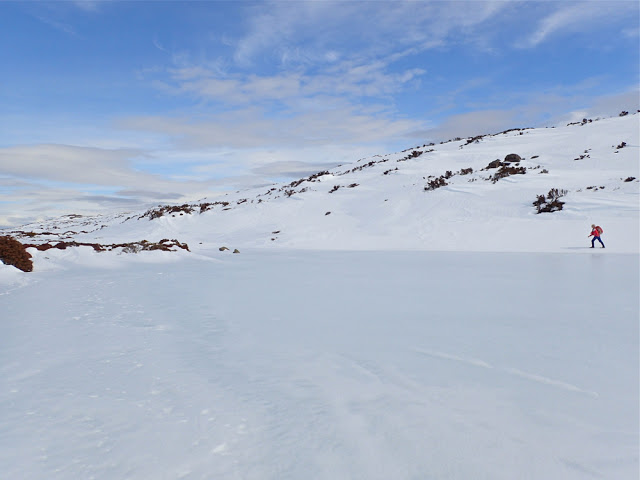
This is also not my photo, but one offered to me by another friend, Catherine, showing me walking around a different lake on Wednesday. This is very similar to what we could have been seeing had we been able to see, or had the luxury of time to stop and take it.
Enough was enough. Obviously it seems, if you want a mountain dearly enough, you need to take matters into your own hands. I studied the weather and decided Friday was good enough for a try, despite the fact that either snow or rain was predicted for the afternoon (depending on the temperature). An early frost would at least mean that the snow would be firm for the way out. It would be several kilometres across the top once I’d climbed up to the snow, so I wanted to make sure of being out by midday, just in case it got slushy and slow, and in case sinking with every step became a possibility. It thus needed to be a trip with a nice early start, and one done on the march with very, very few stops, if any. Who would be up for such a trip? My friend Angela, of course. I was so annoyed with five failed attempts that I was prepared to go solo if she couldn’t come, but luckily for me, she could, so when the sky closed in and even the ground became difficult to see, I had the warmth of company.

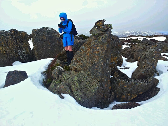
Angela checking the summit. Sorry, it’s just a phone image. Beggars can’t be choosers. Having forgotten my camera, I had to learn to use my Galaxy, which won’t let me download onto my computer, so this got texted to my daughter and then emailed to me. Quality has been lost somewhere in all of that. Don’t be fooled by the shorts. It was COLD. Angela is tough!

Angela and I, as a duo, now have, by default, a very good – yea, pure – record of summitting success in the snow, and this mountain was no exception. I say “by default” as we don’t always set out intending to snow climb. It just happens to be the case. This time, however, the snow was sought out and courted. I thought it would be great fun to have my first summitting of this elusive mountain in winter white. The fact that it was also in a grey-out, done half-blind, just added spice.
At first the day seemed benign. I thought it would be another glorious one, like Wednesday. However, once we gained a contour or two and were exposed to winds coming from the west, we were hit with an icy blast, and quickly donned another layer to cope with the freeze. We were not deterred. It was chilling, but we also both had many more layers in our daypacks in case. To the west, the sky began to look dark and ominous. I checked my compass to note our bearing, as the land was almost featureless. The clouds were rolling in, and yet it was still so bright because of the snow that we both found our gps screens very hard to read; I was glad of the paper map and compass we were each also carrying. Somewhere in the clouds, Clumner Bluff was hiding, but it was a matter of belief, not of seeing – a belief based on the accuracy of map and compass, for the eyes told us nothing.

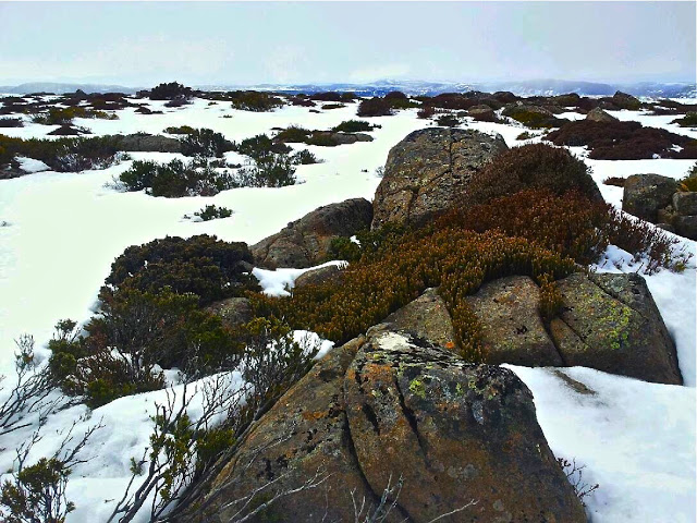
The wildness of the tops

The ground became exceptionally hard to discern. I changed from sunglasses to red-tinted ones, but I still couldn’t detect any helpful patterns in the snow that indicated where the ground was. Like a little old lady, I walked bending low to try to make out the ground. We crossed something we decided was a lake, treading very gently indeed as we crossed it. We had no idea how deep it was, or how stable the ice covering on top. I was so glad to have Angela’s company!!! On the return journey, we evaded that bit by doing a wide arc.
After maybe 50 minutes across the snow, a shadowy lump loomed up ahead. This must be Clumner Bluff. At last we come face to face. ‘Odyssea’ meets her giant. Up we climbed and exactly 60 minutes after cresting the snowy tops, we were standing on what we supposed was “summit B”. I assume this is the “historical summit”. However, even in the grey misty gloom, our eyes said there were higher things to our left (south). My old map told me nothing, as it lacked a black dot of any description for the summit, but Angela’s more modern map had a summit where our eyes said one should lie – apparently 10 meters higher than the one we were on. I really don’t know, and never will, if I would have had the courage to go even further into the dark mist and visually unknown without the company of a friend. I don’t need to know right now, as Angela agreed that we’d go on to touch the highest point, and not just this cairn and summit. It took us a further 15 minutes to reach it, but they were glorious minutes where we felt even wilder and freer than that first hour across the snowy plateau. Somehow or other this was the ultimate: wild and free on rugged eerie tops with wind so noisy we couldn’t hear each other speak; the only marks in the snow were wind waves and the tracks of wombats and wallabies. It was fabulous. And oh was it good to breast that summit rock and know we had at last got to the top of the runaway mount.

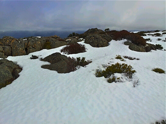
This was the clearest it got during a two hour period, which happened to coincide with when we were on the summit, and when we stopped for five minutes to celebrate before hastening away.

Here, after 2 hrs 15 mins walking from the car, we had our first break, if you call it that. I took four photos. Angela similar, and then we were away again. No food; no drink. We were still both in a hurry, as the weather really was quite nasty, and we both wanted to reach this nice thing called safety before we ate or drank or wasted any time. We had our first break from earnest progress, and I had my first drink and food of any description after 3 hrs 45 (12.15 pm), when we were successfully out of the snow, and about a quarter of the way back down the mountain. I had been right to think we needed to be out by midday. The snow had been a little sludgy towards the end. It started raining lightly as we tightened our seat belts to drive away, both feeling quite excited by the day’s adventure, and very, very satisfied with all that had happened.

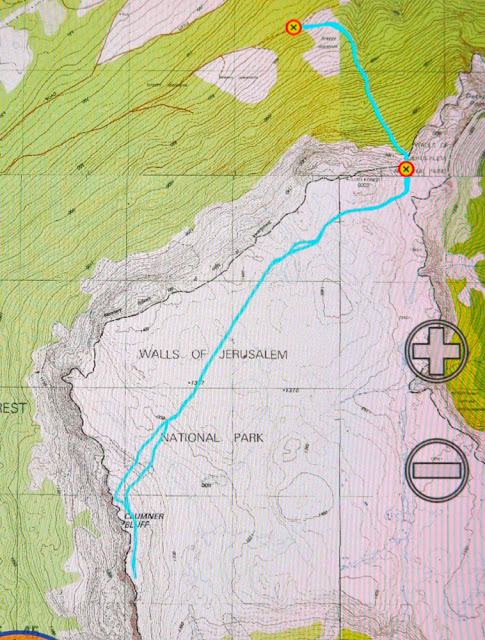
Our walking route in blue. For instructions on how to get to the start, see the post before this one on XC skiing. We parked the 2WD just before the puddle, as suggested, 4.3 kms from the turn. At the puddle, you turn right, head up a steep section that 4WD cars with courageous drivers can do, until the tapes indicating the start. The additional walking resulting from parking that bit early meant we had to walk an extra 6 mins 45 to reach the carpark for the brave and well equipped.

For the first time in my very long life, I forgot to take my camera with me!!! It was in the car, but I thought it was in my pack. I realised 10 minutes into the walk that this was the case, but was not prepared to lose 20 mins getting it, given that I had calculated that we needed to be out by midday. As it was, our progress was so purposeful that I would possibly not have had time to use it apart from at the summit anyway. Wednesday was about photography; today was about business – if you call feeling the wondrous expanse of infinitude in nature’s wildness “business”.

16 kms; 500 ms climb = 21 km equivalents. 4 hrs 45 walking (plus lunch and four photos).

Dundas 2015 Jun

Mt Dundas June 2015

For some reason – well, actually, for a very good reason – I was a bit scared of Mt Dundas. As you may have gathered from photos, ice and snow dominate our scenery at present. Fine. Beautiful. The trouble is, this mountain begins with a river crossing, and we were under the impression the water would be knee deep at best (thigh at worst) and rushing. I would be climbing in snow with sodden feet, a sure recipe for personal misery and possible hypothermia. I was so anxious I even had nightmares as darkness morphed to dawn. Gulp. Here comes day: my moment of testing.

Monika negotiates the rocks near the summit

Down we went to inspect the infamous creek, scene of my sure doom. Hey. There was a branch I could clutch and swing from – Tarzan’s wife – over the slippery, slightly submerged rocks. I didn’t need to get my feet wet.

I don’t know why I had imagined that Dundas wouldn’t have rainforest at its base like almost every other mountain in Tasmania. Perhaps because nearby Tyndall is not impressive in this aspect. All I did know was that there was an old road one followed for a while after crossing the creek, and that it was “very overgrown”.  Well, yes, it was … a bit … but not so much that it was a problem. Up we climbed through glorious, lush, mossy forest to the point where “road” became pad, replete with tape in several hues. My favourite section was the stand of King Billy pines that rendered the path a carpet of textured needles in various shades of brown. My second favourite was when this was replaced by a different study in brown and ochres made by fallen fagus leaves.

Kent and Monica on the summit

Once we mounted the top of this ridge, the land flattened out for a section of tiny wombat pads through low lying scrub, one pad of which was used by humans. The final climb was now visible, but the summit still seemed a long way off – both in terms of vertical and horizontal distance. It seemed to me that it was too far away to be achievable on this short winter’s day. I pessimistically predicted failure to my two companions who betted on the contrary that we’d be there by half past one. I owe Kent a cake at Zeps, I am very pleased to say. I like placing bets that I hope to lose.

Here comes Jack

Not at all deterred by the possibility of having to buy cake, on we continued, taking especial care in the snow. I happened to be the one making the footprints in the end game, and needed to be particularly careful: it’s easy to assume there’s a rock under the snow and to fall and hurt yourself if there isn’t. Aware as I was of the dangers in this section, I was simultaneously aware of how grateful I was to Rupert for putting on the walk, and to HWC for enabling me to connect with others who are crazy enough to find climbing a mountain in mist and snow to be a fun idea. I know we are not the norm.

I was thrilled by the thwarting of my own pessimism when at last out of the gloom a mound appeared that was definitely the summit. Several false promising ones had made their appearance as we climbed, but this one had no shapes beyond. At last there really was nothing higher to climb, and Kent and Monica had even been a half hour too pessimistic in their own estimation of when we’d get there. Every member of the party had reached the top before one, and in fact, we had descended a bit and finished (a very quick) lunch by one thirty. The reason for the speed was not gluttony, but rather freezing fingers and toes that made picnicking in the snow a little less than pure delight. Moving was the best solution to the freezing problem.

Cold it may well have been, but I feel very privileged to have seen and climbed Dundas in the snow. I loved this mountain, and will return one day to admire her summer outfit and linger longer on the top.

A real, paper map will give you the context of where that lower waypoint is – scene of road end and where we parked the car. We then followed the obvious road until a cairn (NOT very far) indicated the path down to the river. After crossing, the old path that will lead you upwards is to be found on your right, and is indicated on the map above by the more easterly path which followed the road the whole way. The upper waypoint (2 of 3) is where the old road ends and the pad begins; basically, if you are heading up to the sharpest part of the spur you can’t miss it.