Scorpio 2017 Apr

Mt Scorpio, Apr 2017

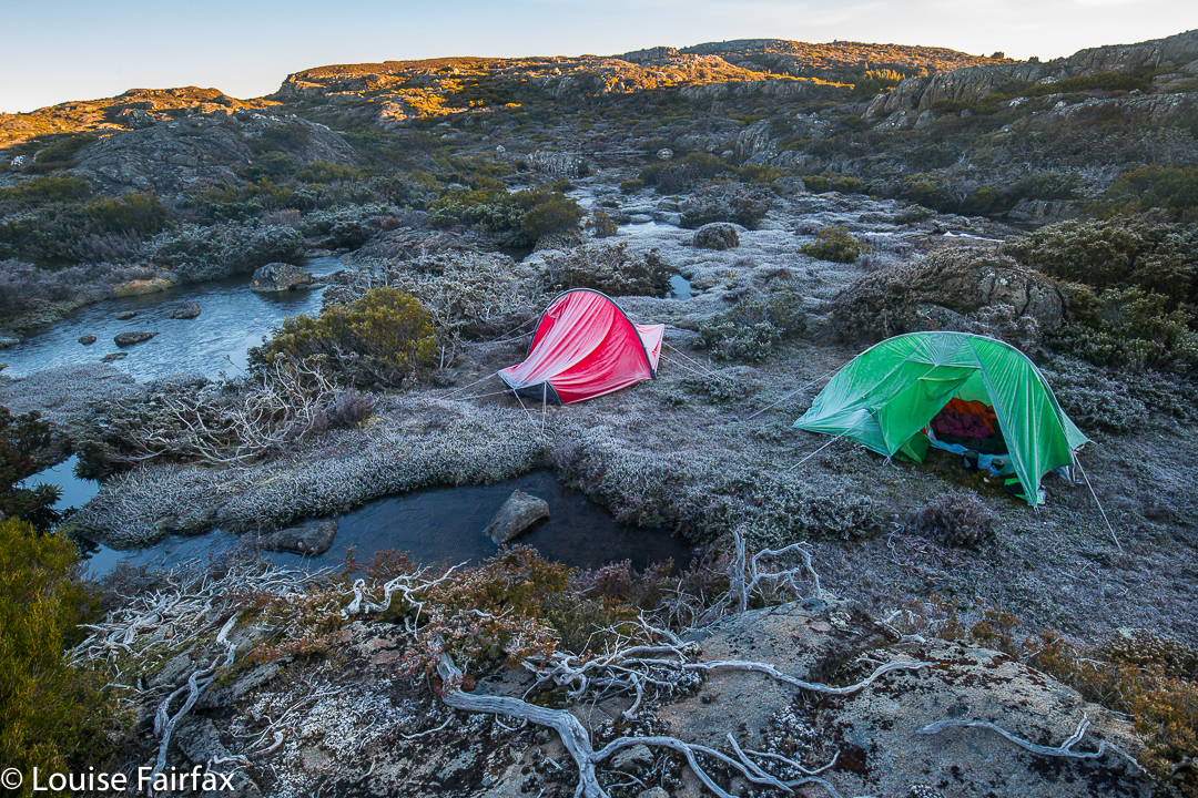
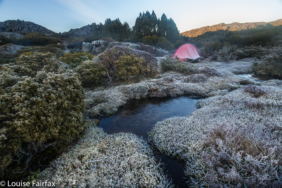
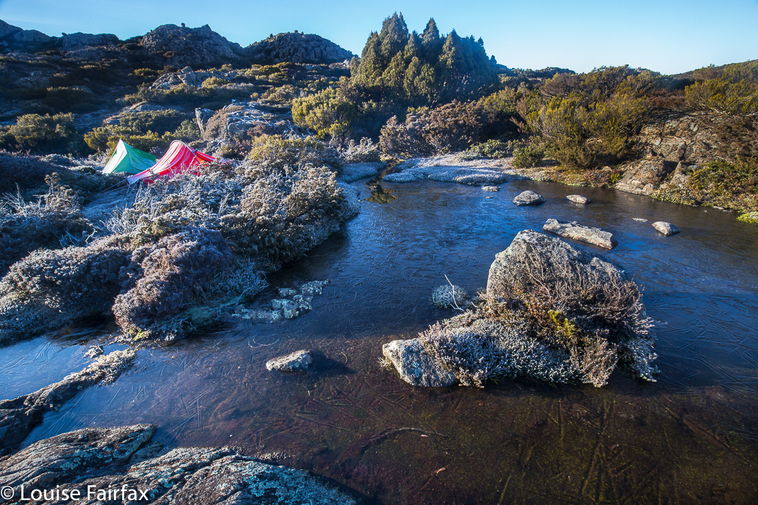
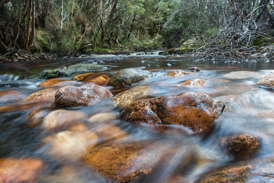
Our camping spot, Seven Mile Creek.
Mt Scorpio, stuck out there towards the eastern end of the Western Arthurs, has always had a certain allure. Perhaps it’s Dale Lisson’s photo in the Abels II book, with diminutive, rucksacked figures walking up a knife-edged slope, that gave birth to my feelings towards this mountain, and created a mixture of respect and fear, combined with a  desire to be on it myself one day, and to summit it via that edge.


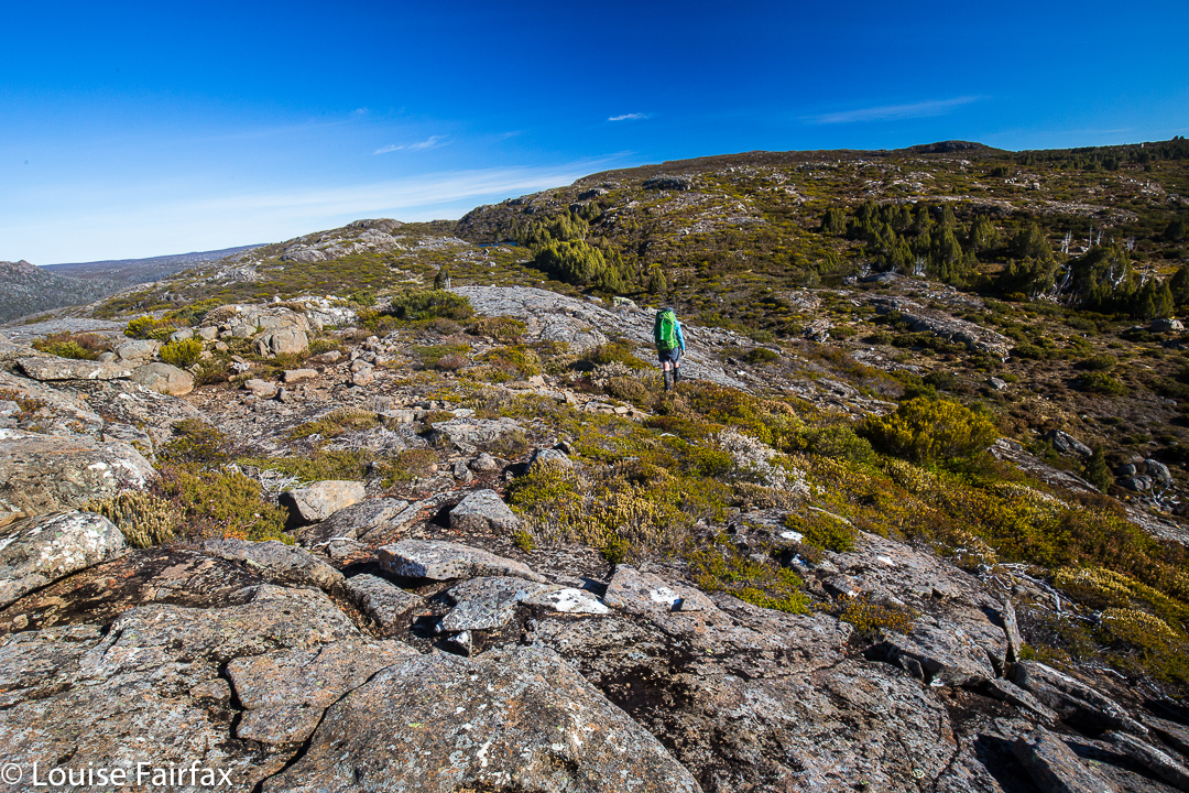
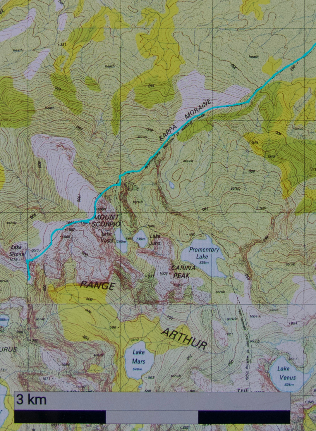
Climbing Kappa Moraine.
At last I got my chance this Easter. Unfortunately, a different book said not to climb it in wind. Even more unfortunately, the weather whipped up a beauty of a blast, together with mist and rain, on summit day. Oh well. That’s nature. She doesn’t cede to our desires.
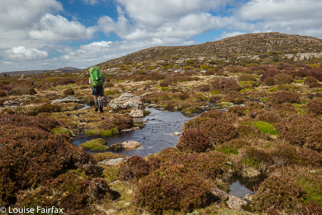
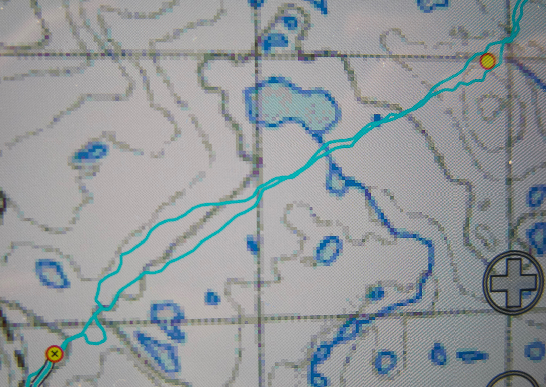
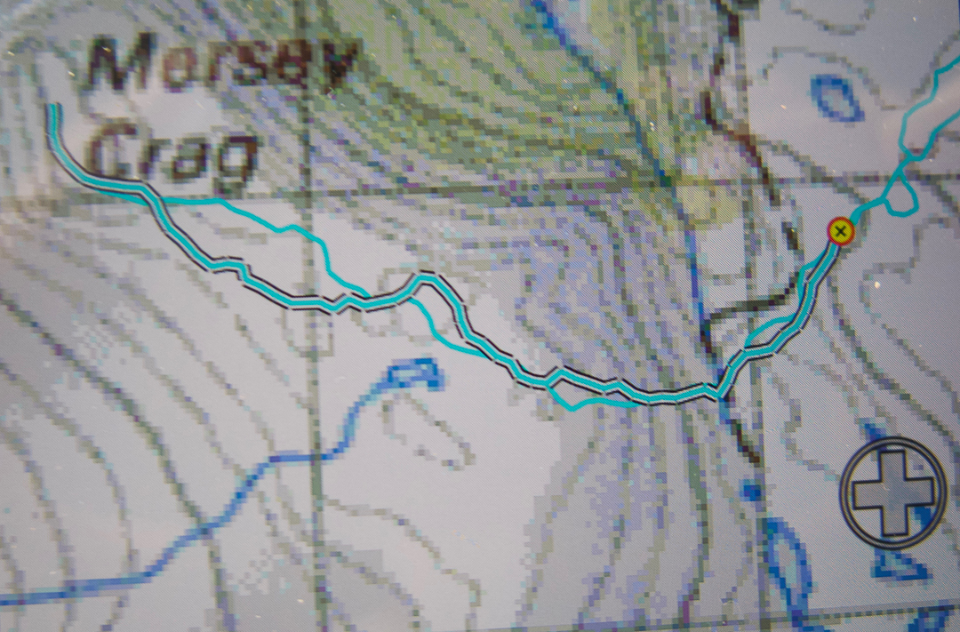
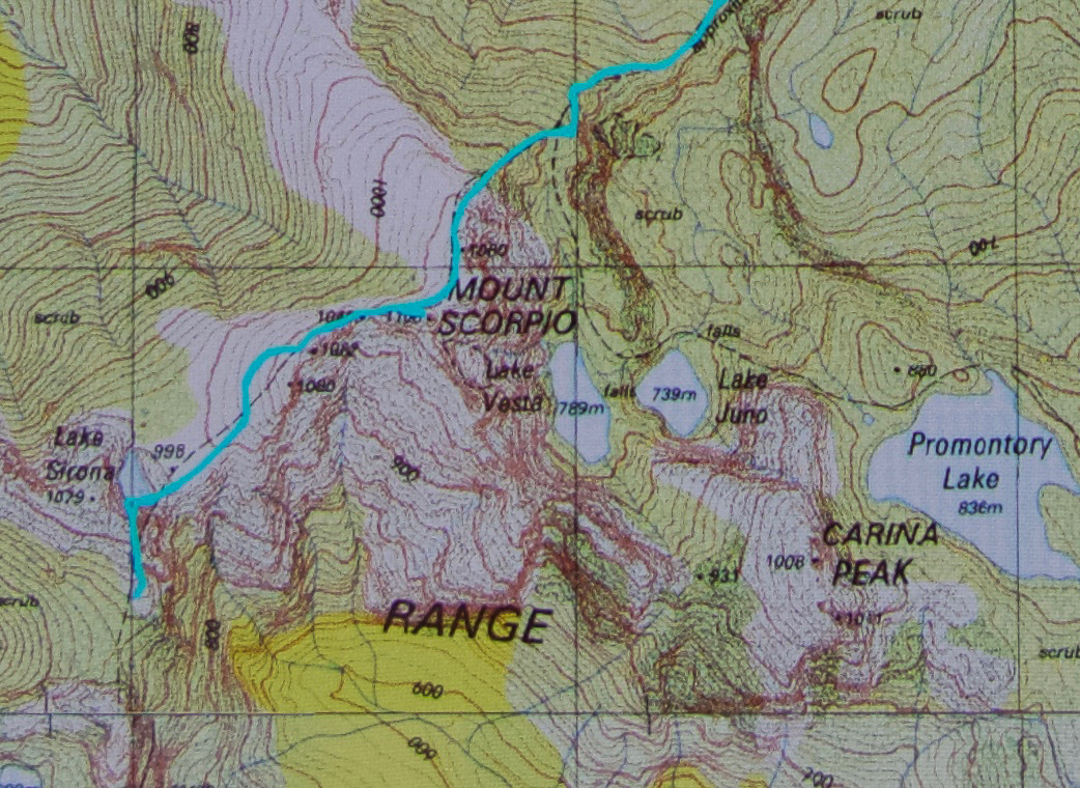
On our first day, we had walked in over 20 kms along the MacKay track to Seven Mile Creek. It was not necessary to walk all this way – there is a Kappa shortcut in existence – but we decided we wanted to camp there this time; we’d go up the shortcut on our second visit to the area (we both envisage many visits yet to come). We knew the forecast for summit day was not good, but Angela is a working woman, and sometimes you just have to take what you can get.


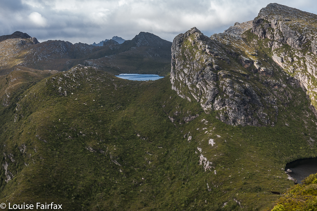
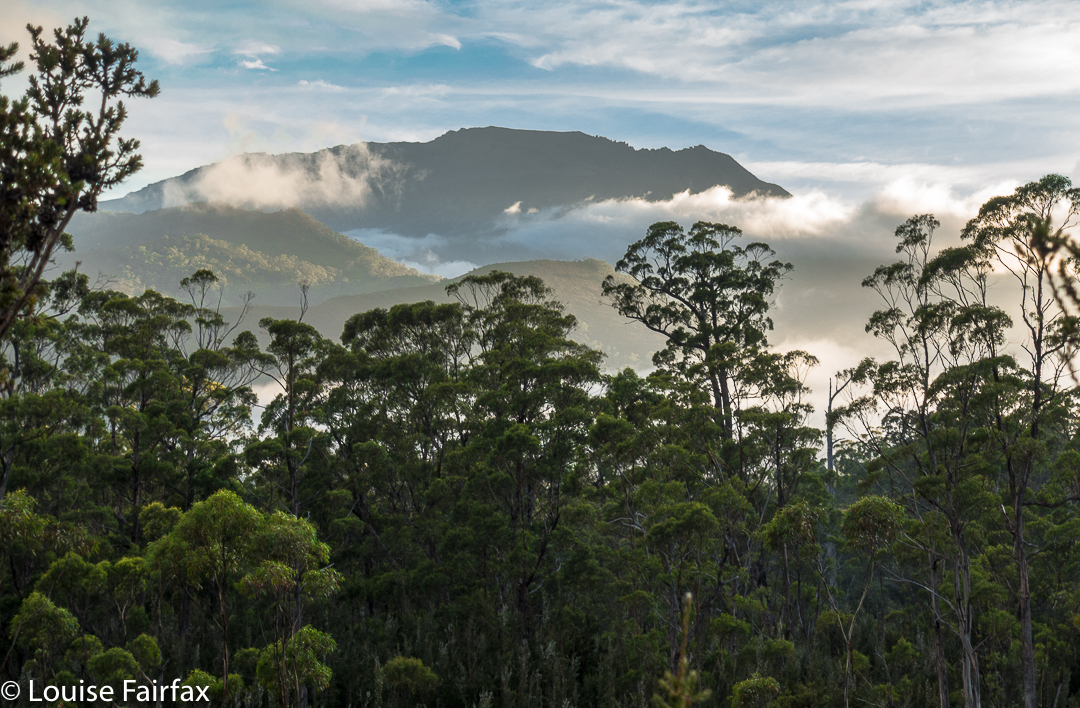
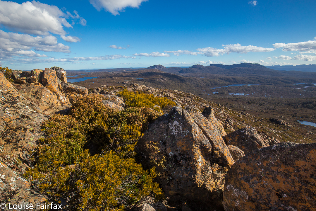
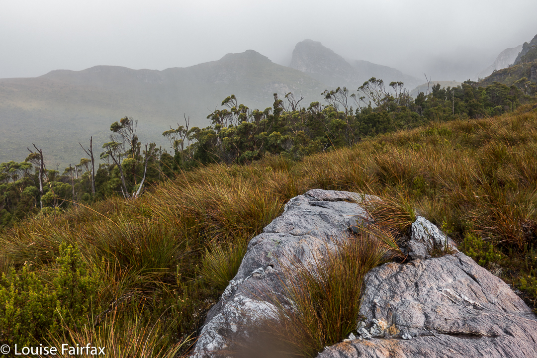
We both loved this glimpse of Promontory Lake before the clouds came in. I must go there one day!! And I must climb Carina Peak to its right.
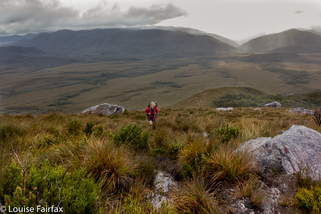
We were quite hopeful as we walked across the plains from our tent site next day (about one hour’s duration). It was cloudy – a little bit misty – but that was all. At last we were climbing, not having a clue if one of the mountains we were looking at was our mountain, or just a kind of prelude to it. We only got glimpses. We could feel the wind increasing, so, short of the top, donned extra layers in case it got wild up there. Good move.


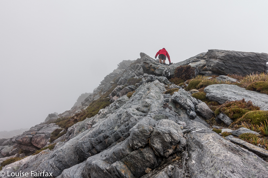
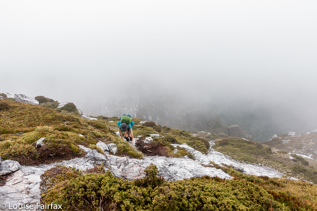
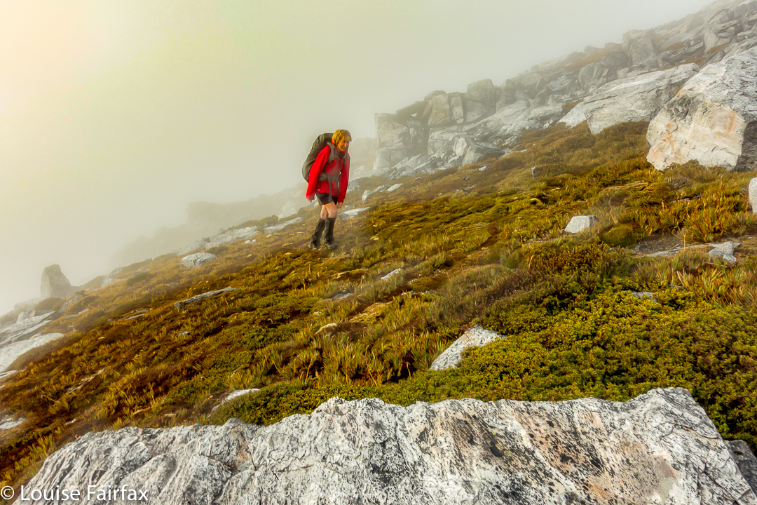
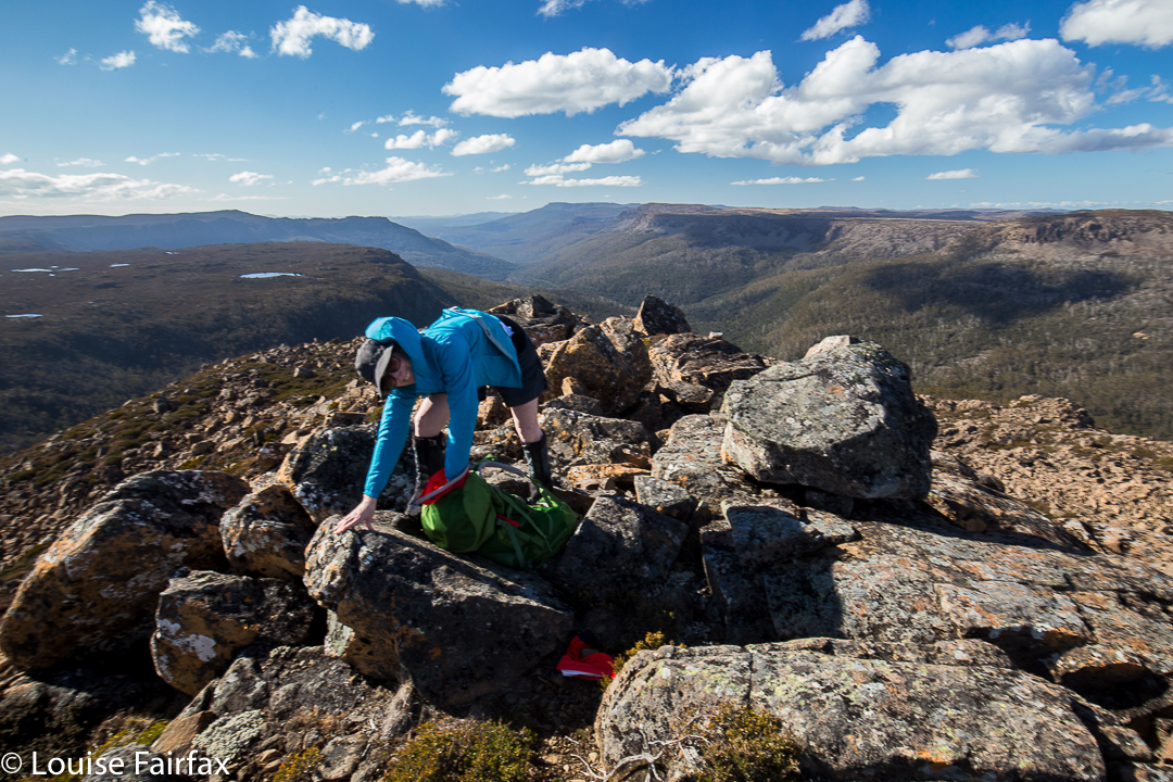
Angela climbing the final stretch.
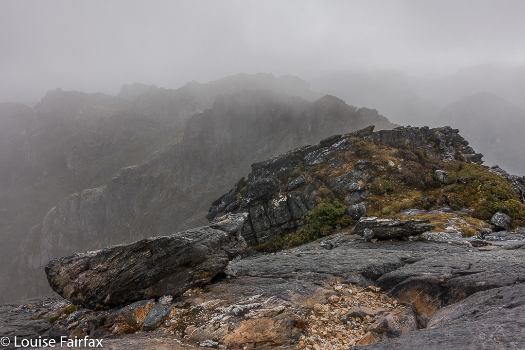
The Abels book implies that you just kind of walk straight to the top, but when we reached the nearer end, we could see no obvious route up, and certainly not the one of the picture, so I voted that we go to the further end instead. THERE we found the scene I was awaiting. I didn’t want to completely copy Dale’s image, so chose a different angle and asked Angela to please go on so I could photograph her on the dramatic slope. The wind blew more strongly.
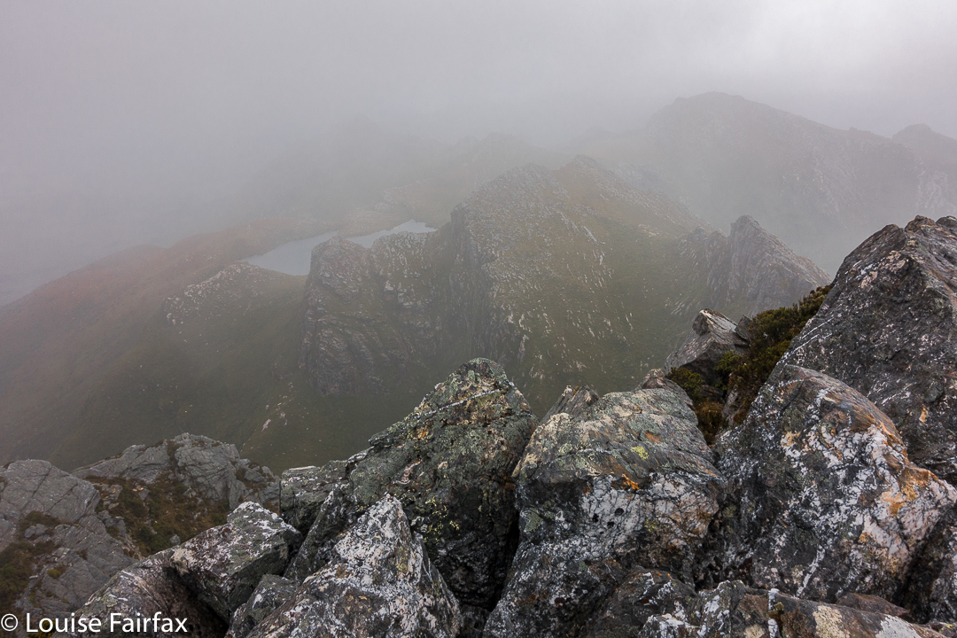
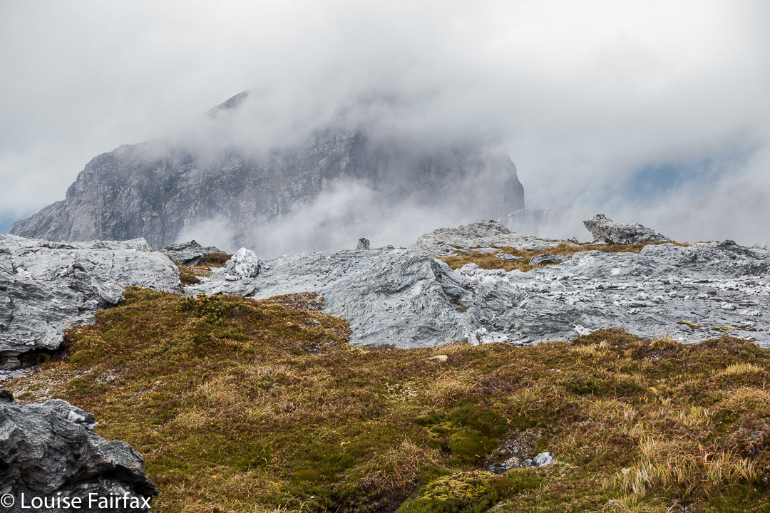
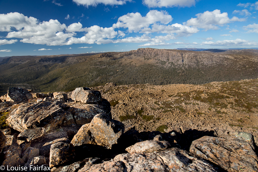

Summit “view”.
After she had finished posing for me, Angela ducked left, not enjoying the deadly drop down the cliffs to the east, and heeding the warning not to climb on the ridge on windy days. I followed up at this stage. I saw where she had gone, but was rather enjoying the airy space, and had plenty to hold on to, so kept on the blade. I got to the summit, photographed, wondered where Angela was, and began to descend, hearing her calling  me as I did so. The wind was so strong I couldn’t hear what she said, and neither did she hear my full answer.


When I got back to her pack, and saw she was not there, mild panic set in. (She didn’t want the wind buffeting her rucksack, possibly knocking her off balance, so took it off for the final climb. On the other hand, I wanted my back protected from the iciness of the blast, and thought that if I fell, I’d prefer to land on my pack rather than my bones. If you could see the drop, you would know that whichever part of your anatomy landed first would be utterly irrelevant, and that pack or no pack would be of no consequence at all. Be that as it may, my pack stayed on).


I was unbelievably relieved when I saw her emerging around the corner. Her yell had not been for help: it had been to tell me she’d found a cairned route up that was not exposed at all. She enjoyed her route. I liked the mild adrenalin rush of mine, as there was no real danger if you didn’t let go, and the handholds were firm.
All of those antics complete, it was now 10.30. We decided that, despite the weather, we’d continue on towards Aldebaran. However, with each step, it seemed, the rain got stronger and the wind more forceful. We had to cross a saddle before Lake Sirona, and in this stretch, I was blown a metre to the east on several occasions. It was taking all my might to fight the wind.


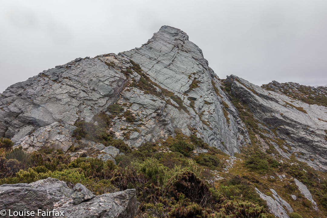
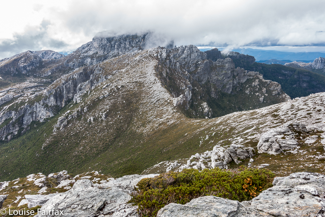
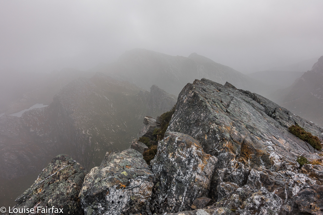
The knife-edged ridge from beyond.
Up we climbed, … up a chute which was quite slippery, but doable, and along to another saddle. Ahead in the gloom lay numerous lumps and bumps of unknown difficulty. This next saddle, like the one before it, had huge drops on the leeward side. I was now moving very slowly in my attempt to deal with the effect of the wind and to protect myself from a huge but terminal flying lesson.  I wasn’t moving fast enough to stay warm, despite my multiple layers of clothing. Reluctantly, I told Angela I thought I should quit. She was very obliging, and about we turned.


The way back was windy and wet, but as we got lower, I could move more quickly and thus stay warmer. It was far more fun being out there dealing with wild nature than lying in a cosy tent, that’s for sure. We were back mid-afternoon, and seemed to spend most of the remaining hours of the day eating, calling the food a variety of meal names.


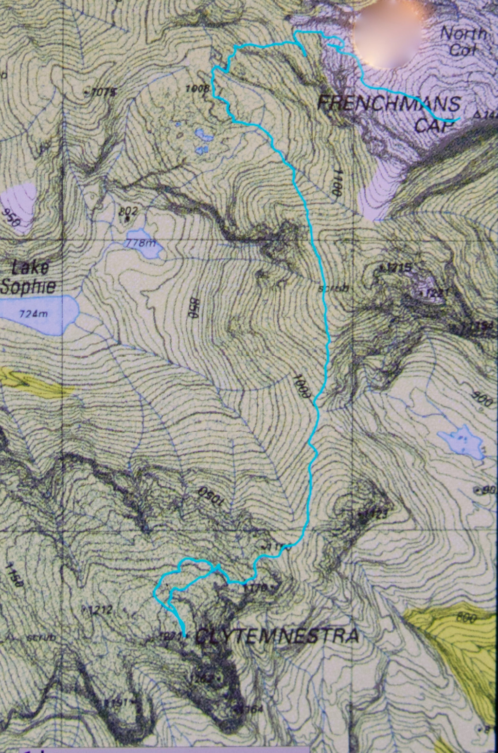
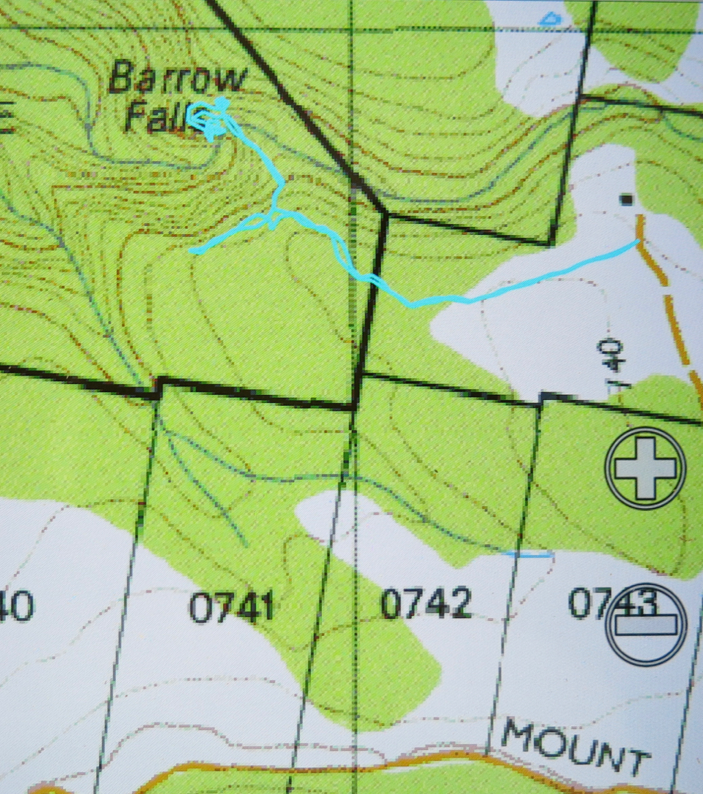
You can see we climbed the final stretch via the “back door”.

Blackboy 2017 Apr


Mt Blackboy is not the most exciting mountain I have climbed, but it’s there on the Peak Baggers’ List, so I wanted to see what it was like. I led a group of people who had never walked offtrack before (club walk) – who didn’t even quite know the meaning of the word – so that was a little disquieting, but they coped fine, and I think it was a great little mountain to introduce people to moving through untracked bushland. Poor Kai is off to buy himself a pair of gaiters! They all agreed that far more coordination and balance are required for that kind of work. Hopefully, they all gained a sense of achievement at attaining their first such summit.

My maps app said the fastest way to Mathinna from Launceston is to go via Fingal, and I decided it was correct, based on how VERY long it took me using back roads last time. Despite holdups due to a car race, as well as roadworks, we were still there in under two hours, as compared with two hours thirty using the “shortcut”.  From Mathinna I headed mostly north, using Dilgers Hill Road to go around the top of Mathinna Falls (in a westerly direction at that time). Once we could clearly see Blackboy, I just headed for it, choosing a road that edged around its eastern side. You could follow this road further than I did, but there was a bit of fallen timber, and I didn’t want to hit a dead end and then have to back a long distance, so I parked early, and we were all happy to get more walking for the drive. Even with the longer walk, and with people who took the bush pretty slowly, we were both up and down in a bit under half an hour (each direction). The roads I was on were not on the map, which is why my blue track appears to start in the middle of nowhere.

Clytemnestra 2017 Mar


Beautiful morning on day 1 to begin our mission.
When I first heard that to climb Clytemnestra one needed to drop over the edge of Frenchmans Cap, I was filled with horror. Do you know the cliffs that shape the Frenchman, my reader? They seem formidable from any distance. However, the notion of climbing all the Abels had been planted in my brain by my former climbing partner, and had taken root there, and if I wanted to achieve that goal (still not sure, actually), then I needed to conquer any misapprehensions I felt with regard to dropping off the Frog’s hat.


Climbing Frenchmans
Off Angela and I set on the start of this little mission, past Vera Hut too early for lunch, which we had upstream. In case you’re also there in a dry time of year, I’ll tell you that the last water after leaving Vera is about 45 mins up the track, where it crosses the creek for the final time. We arrived at Tahune Hut  mid-afternoon in plenty of time to choose a scenic spot for out tents, to organise our gear, and to go swimming (Angela) or to chat with others (Louise). I must have sweated a lot, as I needed a copious and salty afternoon tea, staring out at mountains reflected in the amber waters of the lake.


Our plan for day 2 of our venture was to set out at 7 a.m., but at 6 the continuing sound of heavier-than-we-liked rain had us push back the time to 8, … and then to cancel the idea of climbing altogether. However, at 10 it looked as though it might be clearing, so we decided to give it a go. Maybe this was a recce, maybe this was a climb. Time would tell. At least it was some exercise for the day.


Getting near our goal by this stage
We were on top by 11, enshrouded in thick mist, but decided to continue this recce business a bit further, and to try, at the very least, to find where we’d drop off the cliffs on the morrow, perhaps saving ourselves time then. We attempted two chutes that ended abruptly in dead ends (excuse the pun), but on the third attempt, managed to negotiate our way down the slippery rock with success, which meant we reached a knoll near the two tarns at the mountain’s base, 1 hr 10 mins after leaving the summit. I was still in recce mode. Angela didn’t comment. On we pushed, now proceeding up the lightly bushed ridge that connected with the main Frenchman-Clytemnestra one, and then contouring around its belly to avoid unnecessary climb. When we rounded that bulge the mist cleared enough to give us a brief glimpse of our grail – way, way closer than I believed possible. Angela was now excited and announced that this was no longer a recce. We were climbing this thing and now. I would continue forward, but reserved judgement on the certainty of success.


The cliffs of Frenchmans, teasing us while we had lunch on Clytemnestra
Into the final saddle, with only some cliffs between us and the summit cairn, I still refused to believe. Up, right, up, right, we climbed, walked, climbed, walked, until, truly amazing: there, fifty metres in front of me was the summit cairn. Only then did I allow myself to believe we were really going to do it. Ceremoniously we approached and touched together.


The route back to Frenchmans. We thought the mist was clearing!
We had lunch on top, watching the mist swirling around us, every now and then allowing a teasing half-glimpse of the silhouette of Frenchmans. At this moment, when I decided to consult my phone which had been tracking our route, I discovered that the battery was basically dead and I couldn’t even see the screen. Our homeward route was thus concealed, but, no worries, we have memories. Off we set.


We have to go over Frenchmans (back) before we drop down to our tents.
There were no mishaps until it came time to choose which chute we needed to use to climb back up onto the main massif. At that time, the mist was particularly thick: visibility was zilch, and it felt like hours later than it actually was, with so little light penetrating the thick clouds. I did not like this at all. It felt like these conditions were set in for the remainder of the day, and we would never be offered a glimpse of a possible route. We were in a nasty cliff maze with no perceptible way out.


Eerie light as the sun tries to break through (before giving up again).
Luckily, before we left home, I had emailed Hobart Walking Club and received a gpx route, which I had transferred to my phone, and forwarded to Angela, who had also downloaded it. Now was the moment to consult this route on the phone that still worked. We could see the other club-member’s track, and our position relative to it, and note that we needed to contour a bit to the east before we would intercept it, and then follow it due north for about 150 ms, when, with luck, an attractive chute should reveal itself. It did. The feeling of relief as we emerged on top, and I knew that we just had to keep climbing – no more chutes, no more difficulties – was enormous. As we climbed higher, safe and sound, mission successful, a kind of golden circle where the sun should be coloured the mist and lent the landscape a temporarily yellowed hew. Everlasting daisies, in funny, closed cups, shone silver in the tinted light.

Barrow Falls 2017 Feb

Barrow Falls, Feb 2017.


When researching available information to learn how to get to Barrow falls, and to see what I could expect, I noted that the material made them sound a little formidable. We thus wore our full bush battle gear for the journey, and were not actually confident of reaching our goal: “Don’t worry”, said my husband as we drove towards where I wanted to park and eyed up the rather thick bush to left and right, “we have six hours until dinner.”


I drove down the orange track on the map that I wanted to use for my approach, not quite knowing what would be at the far end. Hm. A house to the left, with furiously barking dogs, and one at the end of the track, kind of opposite, that did not look exactly used. I knocked just in case, anyway. By the time I was back near the car, I could see a lady striding towards her gate from the house above. We smiled at each other as I explained that I had come to ask permission to try to get to the waterfall from here.


“Yes, this is my property. Go and enjoy yourselves. Head down here until you see pink tape and follow the tape to the falls.” What? THAT easy?
“Oh”, I laughed. “We have maps and compasses and a gps system. I thought it would be challenging.”
“Oh well, it’s always handy to have such things,” she chuckled.
Next question: “We have a dog in the car. If we keep her on a lead, can she come too?”
“Don’t bother about the lead”, was the reply.
As a result, all three of us (two humans and a dog) had a fabulous time. Tessa was soon joined by the owner’s retriever, so even made a new friend. The dogs had a lovely swim in the creek when we arrived. The retriever seemed to know his way around very well, and took over leadership of the group pretty soon into the expedition.


Hoorah. A dog friendly walk in Tasmania!!!
Our gps, map and compass did come into use on the way back! There was another lot of pink tape going to a different destination, and I followed it at first, without realising that it wasn’t the original tape of our entrance. Luckily I sensed that things were not as familiar as they should be, and checked our position with the gps – no, we were now well off the old track. I righted it with a compass, and soon enough we were back where we wanted to be. I am also very happy we both wore boots. It was VERY steep in the final descent to the river, and equally steep – and slippery as well – trying to get from the top of the falls to the base. Huge, loose rocks became easily dislodged, vegetation was slimy: boots felt nice and secure.


After all that exercise (16 minutes in each direction to the top of the falls – ha ha) we, of course, needed to refuel our tanks, so stocked up on delectable goodies on the way home to have a celebration afternoon tea. That was a great waterfall.

Mersey Crag 2016 Oct

Mersey Crag via the Back Door. October 2016

When planning this trip, I castigated myself: Why hadn’t I climbed Mersey Crag when the road to it was somewhat open, and when I was so very near the summit? On two occasions I had been within cooee of the top, yet had not gone there because I thought access to it would always be easy, so why rush things? Why not savour the moment and do it all by itself sometime? Why not? Because floods would come, ruining approach roads and denying us all any kind of access to the area, possibly for years.

Mersey Crag summit, looking down the Little Fisher Valley

So, now I thought I was doing it the hard way, because it was a very long way in, and I thought I was not doing it the beautiful way, because I do so love the Rinadena Falls. Little did I know. Alright, it was a long way in, but we summitted on the first afternoon, so not too long, and what surprised me most of all was the extreme beauty from the moment we rose above the bushfire marks on the Blue Peaks track.

Mersey Crag summit looking across to Turrana Bluff

We reached the base of Blue Peaks in an hour and a half, but were focussed on our far-flung goal, so resisted the temptation to lose time by going up. We would stay focussed on our ultimate goal for now, and not climbing this first peak would justify another visit to this area that we were already falling in love with from the moment we entered the zone of lush cushion grasses with narrow, pure streams running through. On we continued, not even stopping for a break.

Summit area looking to the Walls. You can see Mt Jerusalem, The Temple, Solomons Throne, King Davids Peak and then, further back, mountains like the Acropolis and Geryon.

The official pad finishes here, but a rough hint of a route around the first two lakes – one followed, we suspected, by many fishermen – continued until we needed to cross the outlet stream separating Little Throne Lake from Grassy Lake. All this time we had no idea of how soggy things were going to be up here, or how many detours we were going to have to make around tarns, or, for that matter, how deep the many, many creek crossings marked on the map were going to be. Here was our first real creek. Hm. Up and down we go, looking for a place to cross. It is mostly wide and deep and flowing quite swiftly. We find a possibility, but it is risky. Will I fall in and get everything wet?

The frozen tarns of our tent site

Being a shocking pessimist in such matters, I opt for a double crossing, first with my pack, and then with my precious camera. Believe it or not, I even took off my jacket and jumper in case I fell in and wet them. Unscathed, we sat on the other side of the river and had lunch. Little Throne was just behind us now. From here on would be genuinely trackless wilderness, pure freedom to choose our direction and path.

Morning glory
We set bearings from our paper maps, but also plotted our course on our gps systems to check our progress, and off we set, around Little Throne, past nameless bumps of great beauty, offering excellent views, and past thousands of tiny tarns, all sparkling in the afternoon light. We just adored it. All further creek crossings and tarn skirtings were problem free, and we were happy with our progress.

On Turrana Heights, we reassessed. I had originally suggested that we go for four hours with the full packs and then summit from there, but I was so happy with my pack on my back I kept pushing for further. Having the packs with us reduced all stress about whether or not we would make it back to where we had dumped them. We have both been quite sick in this last week. Angela was off work with a virus, and I had been to the doctor’s the day before with a combination of bronchitis and asthma. I found it hard to read my body under those conditions, and my pack meant security. If I hit a wall without notice, then everything I needed was right there with me. Angela was fine with this. On we continued until nearly four and a half hours, when we saw an irresistible spot just before the Turrana-Mersey saddle. It was now less than two kilometres to the summit, and only 3.15 in the afternoon. We could set up our tents here, saunter to the top and still be back in the light with no problems. Angela ate lunch part two.

Cresting the summit was very sweet. There are summits and summits, and this was a good one, as we had both held doubts about whether or not we could make it given the amount of water there might be to negotiate, given the distance, and the uncertainty of our health. When you doubt, the victory is felt more keenly. We had time in abundance now we were there and had our tents so close, so enjoyed the top, savouring the extensive view and delighting in all we could see. At a very leisurely pace, we ambled, almost reluctantly, back to our little tents.

We had both been snug and warm overnight, having both elected to use our extra bivvybags. I had actually been a little hot and had stripped down during the night. It is testimony to these bags that we discovered in the morning that our tents were rigid with ice and the world outside our aegises was a sparkling, glittering white one. Enthusiastically I snapped the frozen tarns and sword-like pineapple grass. I had lugged my tripod all this way, but, sadly, was too cold to use it. I told myself sick girls have an excuse.

Back home we go
We swept the ice off our tents with brooms made from the scrub and slowly packed up. The only pressure for the day was our appointment with the Raspberry Farm for celebration cake, and there was no risk of missing that. We deliberately left unfinished business in the area, planning instead the next trip as we bypassed peaks that could wait for next time. What a glorious weekend.
Route data: Day 1, 20.35 kms +702 ms climbed yields 27.3 kilometre equivalents. Total of 7 hours’ walking.
Day 2, 14.55 kms + 410 ms climb gives 18.7 km equivalents. 5 hours’ walking.

Total for two days, 46 km equivalents and 12 hours’ walking (this does not include breaks like lunch or morning tea). OK. We’re allowed to be tired. Here are the maps – rather a lot of them, as we covered rather a lot of territory and it is pretty complex (4 interconnecting screen shots).

From end of track to south of Little Throne (1:100,000)


Continuing SSW over the side hump of Turrana Heights

From the unnamed lump SW of Turrana heights heading towards the Turrana-Mersey saddle. The waypoint marks our tent spot.

Tent to Mersey Crag summit return.

Note, these are “only” 1: 100,000 scale, chosen to give the broad shape of the land without too much detail to confuse.