Donaldson 2017 Mar

Mt Donaldson, Mar 2017. Tarkine Trip Day 2.


With the floating feelings brought on by last night’s magnificent performance at Zeehan’s Gaiety Theatre (Ode to Nellie Melba, with Opera Australia’s Lorina Gore), our merry band of eight walkers from HWC (don’t all walking clubs do opera??) set out to drive to Corinna, where one member would go on a boat cruise, and the remaining seven would climb Mt Donaldson, only about ten minutes’ drive from the lodge. It was going to be another hot day, so we set out as early as was practicable, and didn’t bother pitching our tents until our return.


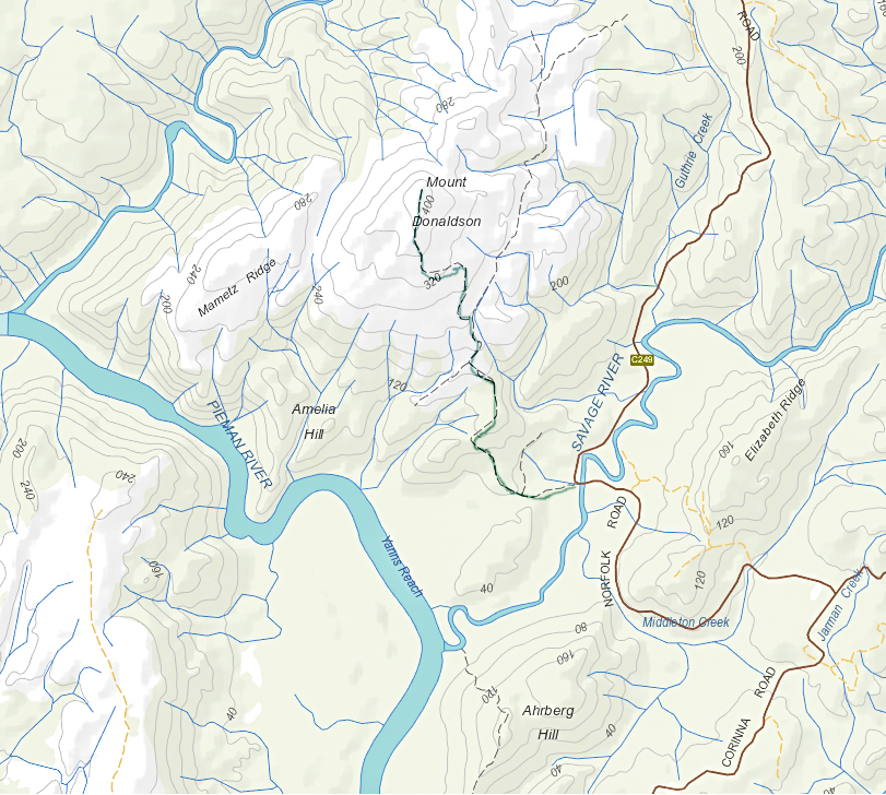
The walk began across the road from the parking space at the Savage River bridge, a beautifully shady place to park. As per yesterday, the leader didn’t mind my odd little ways, so I was not required to stay with the group, but permitted to climb at my own ‘happy pace’. I felt very free and light.


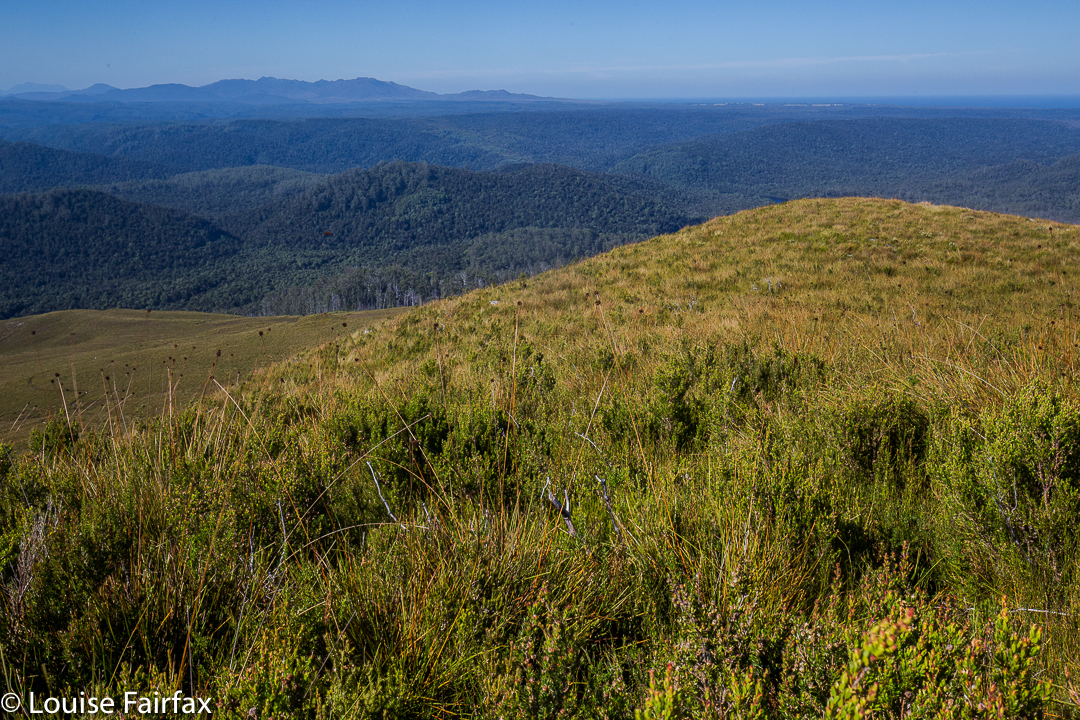
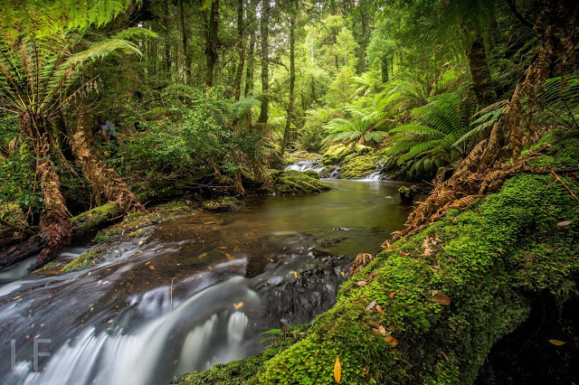
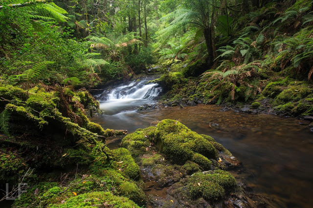
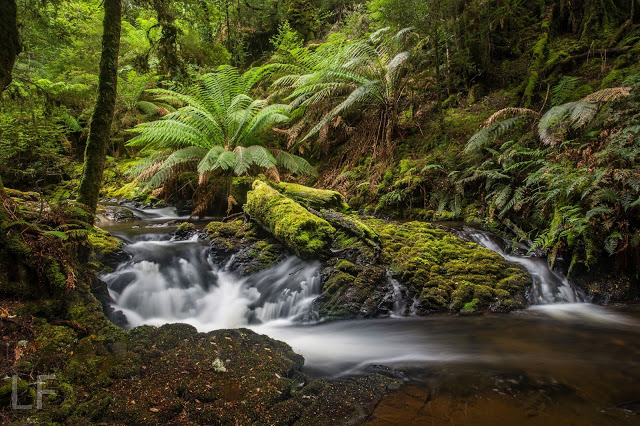
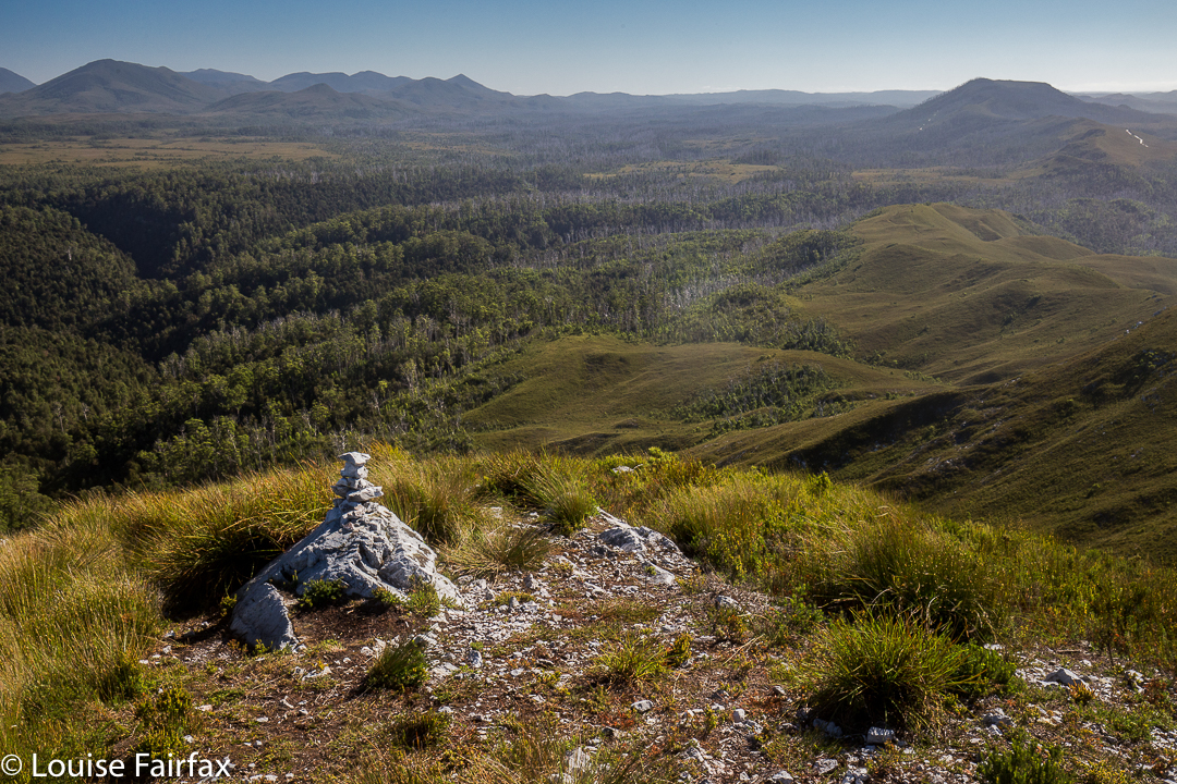
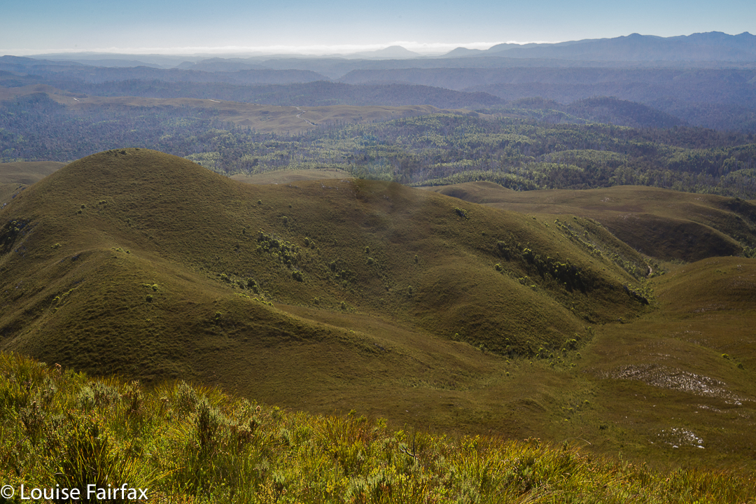
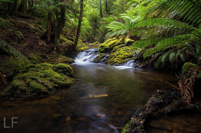
Sometimes it’s great to be alone and just enjoy nature, moving at a pace that pleases. There’d be plenty of time for socialising as a group later. Because I was allowed to move at workout pace, I arrived at the top in light that had not turned to glare. The world seemed fresh and beautiful in the still-golden tint. The early rainforest part had been wonderfully lush and green; the higher woodland section, an interesting contrast; and the button grass part offered excellent views of the river snaking below, and of other mountains in the distance. I sang as I walked. Life had been stressful last week, but walking and singing and enjoying the wide open scenes with the narrowed world to myself was a perfect antidote to calm me down.


As with Mt Zeehan, we could see the ocean from up there. Poor Mt Donaldson is not only not worth any peak baggers’ points, it is not even considered an official “point of interest” or a “high place”. This is an absurdity, as it was both interesting and high enough (437 ms) to offer a wonderful view in the early light.  It is neither an Abelette, nor a Bob Brown. It is just nothing – but it is most worthy of a visit. The 4.3 kms from car to summit took less than an hour, but most groups are not chasing a workout, and would probably want to linger on top longer than this restless jitterbug. I was having fun dancing in the breeze, and returned quite quickly to the car where I got in several glorious chapters of my book, once more enjoying tossing off my other responsibilities for a while.  My husband was having a wonderful time with the group.
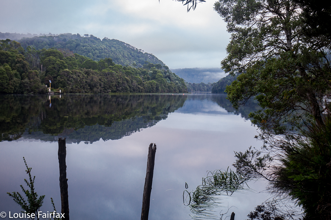
We had lunch under the canopy of myrtles beside the river in a cool and shady spot before returning to Corinna to pitch our tents and enjoy the environs there.

Zeehan 2017 Mar

Mt Zeehan, Mar 2017. Tarkine trip, day 1.
We drove 3 hours 15 mins from Launceston (plus a petrol stop), to reach the start of the Mt Zeehan track, which lies 3 kms south of Zeehan, on the Zeehan-Strahan road. It begins on 4WD track which is on the right (western) side of the road travelling in the direction of Strahan. After that quite long drive, I was itching to do the enticing-looking climb. The 4WD track that one follows – on foot; it is pretty rough – continues as far as a kind of dug-up, worked-over area, after which it morphs into a narrow path. Just before a cleared area, which could be confusing due to all the mess of “roads” and worked-over ground, the “road” you have been following forks. There is, at this stage of writing, a somewhat faded pink tape on the left of this Y. Take the right-hand option, into the mess and out the other side. Your path is the one heading for the mountain, which (on a fine day) is very clearly visible in front of you, slightly right.


Once the narrow track begins, the climb is quite satisfyingly steep (for those who love a good climb), through – as the picture above indicates – fairly open ground, until a saddle is reached. Although it is, indeed, fairly open, my husband succeeded in “mislaying” the track about a third of the way up. He just sat where he was and waited. Because it was so open, I could see his bright red T-shirt from near the top, so knew where to start looking for him. He knew I’d rescue him, so ate his lunch and dreamed a bit.
If he hadn’t lost the track there, he would have lost it in the saddle, for sure, as the flat area there is rather indistinct in terms of the track, and the vegetation gets a little taller. I’m glad he got mislaid in an area in which it was easy to spot him. Meanwhile, I was having fun getting in a bit of a workout, so just went up and down fairly quickly in order to both have some decent exercise for the day, and to return to him. The top was very, very windy, and most unpleasant – not worth a photo at all, the sea just being a hazy blur on this particular day. I’m sure that on other days, the vista would be marvellous. It never pays to climb a mountain in midday glare. I was the servant of another agenda on this day, so had no choice.
In its current state, I would not recommend this track for families, which is sad, as about 1-2 hours of secateur work would make it far more user friendly. Without that, however, any child under about twelve would have bush in its face for most of the second half of the climb, as the bushes have grown together over the track, and are at about the height of a primary school child. One climbs 600 ms in around 3kms (one way), so this is definitely a steep track.
The three hours return which is recommended is more than likely to be a good estimate for most people.

Philosopher Falls 2016 ii Apr

Philosopher Falls 2016 ii Apr

We set out from home late, not reaching Waratah until a bit after lunchtime. We were now in a rush. In the Tourist Bureau, a man overhears that I’m on my way to the bottom of Philosopher Falls and asks if he can join in. He’s already had a failed attempt. I size up his physique for the likelihood of rapid movement. No obvious problems. Jeans. Confident enough to have at least made a failed attempt (the average tourist stays on the track).
“Yeah. Sure, as long as you can keep pace.” (I have driven several hours to be here. I don’t want my attempt scuppered if he can’t keep up with us. He is a total stranger, after all).
“Are you certain?”
“Yeah, that’ll be fine as long as you can keep pace,” I repeat.
He joins us in the carpark at the falls. He’s changed, out of jeans and into boots (good) … and pants that you’d wear out to dinner. Hm.


Off we set, me in the lead, hubby and Man following obediently, down the track to the point where we depart and go bush, from whence I head off on contour along the gps’d track I made last time. Man follows Gretel and Hansel through the forest, repeating oft that he could never do this by himself, and neither could he find his own way back. I stop after 7 minutes to check on how closely the tapes that have now appeared are sticking to the route I marked in last time. He is panting heavily. From exertion or fear? I decide both. Should I take him back and lose time that I don’t have? Not time to give up yet. He makes strongly panicky noises to my husband while I sort things out on the next short stop. Bruce is unsure what to say. What if he encourages him only to find out I’ve decided to take him back? Or if he agrees with the man (that we should turn around) when I’ve decided I can get him there despite the panic? Bruce makes equivocating mumbles. (He’s expert at that).


For the present I continue, believing I still have enough light to get them down. Coming back up will be tricky, but I think things are still OK (apart from the obvious angst) for now. Terror noises grow in volume and frequency. After 20 mins I head back in the direction from whence we came, ending back on the precious path. Man is overjoyed to see it. He totally ignores the fact that we have failed to reach our destination and celebrates his safety. No one gets to see Philosopher Falls (bottom) that day.


I photograph some pretty cascades elsewhere on the Arthur River, still accompanied by Happy Man, who is effervescent now we are near a navigational handrail he can relate to (flowing water). We then part, he returning to Waratah, while we continue on to Corinna. He tells us the road is shocking and will take us two and a half hours. We take this with a grain of salt, and do it in one. We have no booking and are very hungry on arrival. Luckily, this story has a happy ending today (unmitigated pathos is hard to endure). There is room for us at the inn, and we even get to eat a hot dinner.

Philosopher Falls 2016 i Mar

Philosopher Falls 2016 i Mar

The beautiful path to the falls
It was raining. We were in no particular hurry to dash up to the Tyndalls, our ultimate objective for the day (and only a one and a half hour jaunt), so we decided it was perfect weather for visiting the Philosopher Falls, which were kind of en route.

The track unfortunately eschews the Arthur River for most of the way, but you do get to cross it at this point. 

The Tarkine here was beautiful and, to my delight, the first of the autumn fungi were starting to appear, set in a context of lush green ferns, moss and lichens. We were excited, but this was marred somewhat by our arrival at the end of the track, which dumped us at the TOP of the falls. Who wants to see a gaping hole with a bit of white splash, hinting at the real thing below? Not me, and not any of the other tourists we met. All reported disappointment.

Being a little more obstinate than your average, I decided to rectify this matter by climbing down the very steep cliff below me (so steep you couldn’t actually see where it went), despite the fact that my camera gear was around my neck, swaying and banging and not in a rucksack, and that I was only wearing runners. Bruce at least had on boots, but is not exactly equipped for such Tarzan acts these days. Down we plummeted, hoping for a controlled landing, and not a death-inducing lurch should one of the branches decay in our hands. (Sorry reader. They’ll no doubt now put up one of those huge ugly notices warning you that this is dangerous, as if you didn’t have the brains to work that out for yourself.)

Landing down by the Arthur River (and still alive at this stage), we still couldn’t reach the falls – or not dressed in the clothes we had on, and not with Bruce, whose capabilities had already been more than tested by this stage; I don’t think too many able-bodied people have lowered themselves down that cliff. I made a tactical withdrawal, and returned to the top, so tense with the responsibility of choosing a route suitable for my husband that I didn’t even photograph the magic fairyland through which we moiled. If you have information on how to get to a spot where you can actually see these falls, I would be most appreciative.

To add insult to defeat, the sun came out, so it was totally useless taking a photo of the tiny bit of splash you were allowed to see. I departed empty handed, but with some fungi shots that I rather love. Hope you do too.