Meander Falls 2015 Jul

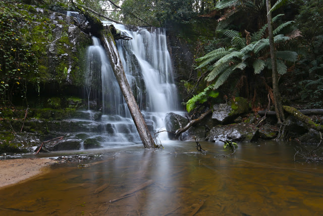
Meander Falls, July 2015

There are some things that every genuine Taswegian has done – like seeing Cradle Mountain or going to the top of Mt Wellington, and I have always thought that seeing the Meander Falls was one of those things. It is thus with a very shamed face that I admit that I went to Meander Falls for the very first time today. I guess part of the trouble in recent years has been that the bridges normally crossed to get there came down in a flood several years ago and have not been replaced, making getting to the start much harder than doing the walk. Certainly, today, that was the only navigational challenge. Once you’ve reached the start box, it’s all easy. You just have to walk on a track for a bit and then you’re there.

The Meander River as you meander your way along it

Both my friend, Angela, and I had certainly been put off for a while by the absence of bridges, and by the fact that the map shows no connecting roads to the start any more. (She is a genuine Tassie girl, however, having been there as a teenager). Our interest in reaching the falls was rekindled recently when friends indicated there was now a way to drive there, so we decided today to give it a try. We made an error or two; I used the 4WD function on my car for the very first time; we skated through some mud when I would have liked a little traction, but we got there to the old carpark with great big signs welcoming us, and we were away.

And there are the falls, behind Angela.

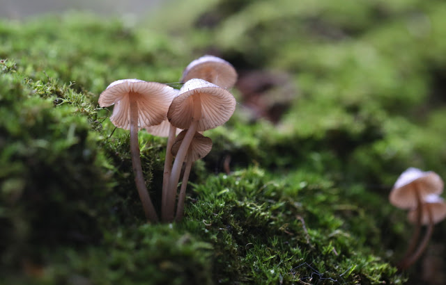
Rain was forecast for the afternoon, so we didn’t waste much time climbing to the falls on the way out – along through pleasant rainforest with the gurgling Meander River beside us. I wanted to photograph it, but even more than that, I wanted to get to see the falls and get out again before the rains came – not only to beat getting cold and wet, but also because I was worried about the huge amount of mud we’d encountered on the way in. I didn’t want to be driving out with any more mud than I’d negotiated on the approach! The sign said it was a six hour return trip, and that sounded rather long with the weather changing. We were very happy to arrive at the falls after 1 hr 40. We were also excited, as the higher we climbed, the more snow we encountered. It was beautiful. And just as we arrived at the falls, large, slow flakes began descending upon us.

Angela kindly didn’t fuss while I wasted time setting up my tripod for she long exposure shots.

We photographed and ate a snack and then returned to the car with no other detours, anxious about what was happening to the mud. We didn’t eat the second half of our lunch until we were out the other side of it. The muddy bit is a new section of “road” which is not on the map, but which has been made, we suppose, to connect to bits of road that are on the map and that can then be used to reach the falls. This walk is on the list of Tasmania, Parks and Wildlife Service’s 60 Great Walks, suitable for families, so we both found it sad that the walk is there and not even overgrown despite its lack of use, but that access is so difficult. There are no signposts to tell you where you’re going. For instructions to the start, please see below.

The route walked. Waypoint is the carpark.
Altitude gained and lost.

10 kms. We took a total of 3 hrs 14 return (plus photos). Just short of 500 ms climb.

To get there:
First head for Meander. There, you will find a sign to the falls (and to the dam. Both use the same road for a while). It’s the only sign to the falls you’ll find. Keep heading for the dam, which is signed.

When you reach the intersection above, turn left. The old road curves right (but you’ll end up in the river if you use it). We had been told to turn left at a cardboard sign, so sailed right at this point, not knowing the sign was deceased, so had to return to this point. After that, take the next two turns to the right. Both are signposted to an Apex Hut.

This is the second such sign.
See that nice road to the left? That’s not yours. See the muck and …. to the right? Yes, that’s your route. Even using 4WD, we did some skating. I would NOT attempt this is a standard car.
This is the connecting road. It links you after maybe 600ms to a very nice dirt road that is easy driving. You follow it along until you get to an intersection, your last one, and here you turn left, noting that you have been on Spur 2. You might like to remember that for the return journey. Soon you’ll arrive at the carpark, and then the fun walk begins.
Here is what I’ve just described to you on a map. The map is confusing as your road (the red line) is not on a mapped road, and neither is the dam that you drove beside, but don’t let little things like that worry you. Just go with the flow and you’ll get to see the falls.

Lady Barron Falls 2015 Aug

Lady Barron Falls 2015 August.


The day we visited Lady Barron Falls, the river was in flood, so the flow was monstrous – almost too big, as its enormity obliterated many of the interesting rock details one normally sees (and its volume created a spray that hard to keep away from the camera lens.


If you want to read the rest of what we did that weekend, turn to http://www.natureloverswalks.com/collins-cap/

My diary records that my husband and I took twenty minutes in each direction. We parked the car at the topmost intersection between the track and the road (centre top below), and just walked in, almost on contour, from there, as we were in a bit of a hurry, having “wasted” a lot of time playing in the snow, and darkness was approaching. (Since when is playing in the snow a waste of time? You know what I mean.)

Rinadena Falls and Little Fisher Valley 2015 Jun

Rinadena Falls and the valley between Mersey Crag and Turrana Bluff – or maybe you’d like to call it the Little Fisher Valley. June 2015.
Progress is not quick when the driver keeps stopping for photos … but who could resist these cows in the dawn light?

If your child says to you: “Hey mum, dad, please take me to fairyland,” please don’t say: “It doesn’t exist.” Instead, pack your lunches and take them to one of Tasmania’s many jewel-secrets, Rinadena Falls. You can all look for goblins, fairies, ents and gnomes while you walk. William Morris or JRR Tolkein would have loved to have set a book there, I am sure, if only they’d been lucky enough to see this place. Magic glades and open forest are what you’ll find there. Gurgling waters can be heard for nearly the whole route. It is pure delight.


Some walks are about reaching the summit; others about the views from on high. Yesterday’s walk was more about just being out there on a beautiful, sunny (but freezing) day, and about getting in a nice long walk to help “fitten” my husband up for Europe. I wanted him to be walking for five hours (not counting breaks). This route took 4 hours 50.

Having not yet climbed Mersey Crag, my thoughts wandered in that direction, even after I’d learned that an extra two hours now had to be added to the time taken as a bridge was down. Last visit to the area, we had taken 4 hrs 45 walking time to climb Turrana Bluff, so this meant we would be looking at about 6 hrs 45 walking plus photo and food stops. Hm. Well, why not just go to that beautiful valley at the top with its marvellous pools that appear from nowhere and equally quickly disappear, that are waist deep yet one step wide? I love those pools. Even yesterday, in sub-zero temperatures, they begged me to have a dip.

Had we started at first light, we could have done the whole trip to the summit, but that would have involved being at the start line shortly after sunrise, and I was in need of a “sleep in”. We didn’t leave home until 7 a.m., and didn’t park at the closed bridge until 10. No time to summit, but plenty of time for what I now had in mind – the valley described above. I was also looking forward to seeing the wonderful Rinadena Falls again.

We allowed an hour for the first part of this journey, which we had driven last time. One blog, by a strong walker, had said 50 minutes, so an hour seemed realistic. I was delighted with my husband’s progress when he hit the old car park at 42 mins despite his Parkinson’s disease. He, too, felt chuffed, as last week he had been rebuffed from a club walk because he was “too slow”. He had been judged by the name of his disease and not his actuality. Having a good split here today helped him to reclaim something for himself.

I expected that road to be boring – some kind of medicine to be taken to enable other activity. This was far from the case. We loved it. Moss grew down the centre, complemented by the lightly tanned dirt to each side. Tiny myrtle leaves overhead framed a tunnel through which we progressed. Gurgling streamlets bubbled their way past us, chuckling as they continued to travel downhill and join the Little Fisher River below. Fallen trees indicated that even if you got your car magically past the bridge declared uncrossable, you would not get more than a short distance along this road that was fast giving itself back to the forest from whence it had come. Frozen fungi laced the scenery.

We crossed the bridge at the end of the former carpark, proceeded 8 more minutes to a cairn, and then swung left to follow a pad with pink ribbons through the lush forest. The tape was helpful, as fallen timber sometimes obscured where the path should lie – but don’t worry. This is still a very family-friendly route. I plan on taking infant Guss there at Christmas to enjoy this enchanted forest and to paddle in the Little Fisher River.

Rinadena Falls were as perfect as ever, so we took a longish photography break here. Half the falls were frozen, augmenting the beauty already there.

The broad valley at the top, framed by Turrana Bluff, lightly clad in white powder to our left and Mersey Crag to the right, was all that I had hoped for when planning this day. Frozen tarns giving white foreground interest, rich colours, crisp outlines provided by the sharp air. All was wonderful. We meandered our way along between the pools of water and ice until my watch indicated it was time to turn around. Mersey Crag was so tantalisingly close, I felt very tempted to ask Bruce to wait while I dashed up, but it was too cold for waiting, and such an impetuous dash would have meant we did the last road bit in the dark. The wicked tempting feelings said: “Who needs light for a road anyway?” Well, we didn’t need light, but it was sure nice not to have to hurry to try to “beat” it, and when we did get to the road, it was very handy to be able to see which patches of ice were more dangerous than the other bits. Our hands, even in the hour before sunset, were frozen to the point of pain. The mountain iced back over as we walked.

 It was also very helpful to get some driving in before it got dark. I reached the bitumen before visibility vanished, which, in those conditions, pleased me greatly. We had had a perfect day, so decided to round it off by treating ourselves to a light but delicious (and inexpensive) meal at the Pepperberry Cafe in Mole Creek. I loved the fact that the other family dining in this attractively set-out restaurant were also clad in the Tassie bushwalkers’ uniform: shorts over thermal longs, thick socks and boots. I was dying to ask them what adventure they had had that day. It was sure to have been a good one.
To reach Rinadena Falls, go past Mole Creek, heading for Lake Rowallan .. After you’ve driven over the little bridge below the dam wall, drive along with the dam on your right for about 3kms, until you see the Dublin Rd turnoff to the left. Take it. Your next turn will be to the right, along Little Fisher Rd. it is the third turn to the right (the first is Clumner Rd, and the second is to a spur). Drive along this road until you reach the pile up of dirt that announces that you are not to drive over the bridge ahead. Park, and walk over the bridge, continuing as with the Little Fisher River to your right, as described above. You will, of course, need a map: Mersey 1:100,000 or Pillans 1:25,000.

Liffey Falls 2015 May Fungi

Liffey Falls – mostly fungi. May 2015.
Mt Bobs seemed a pretty unwise destination when it looked as if every tree in the state was trying to uproot itself, and when the car could barely stay on the road, struggling against the force of crosswinds. Having seen the forecast in the week before, we cancelled our intended expedition (again, oh woe. Will I ever get to see this mountain? This is the fourth cancellation). The attacking rain that accompanied the ferocious wind made the decision easier to bear. Instead of Bobs, my husband and I chose the much tamer alternative of fungi hunting in our local area, and went to Liffey Falls.

There we found abundant fungi, and there was even a rather flooded waterfall at the end.

Coprinus sp I presume. As you can see, they were present in abundance.

I have labelled this mycena firma. Hope I’m right
Hygrocybe miniata is my best guess for this one
Mycena interrupta. No need to guess for this one.
I’m pretty confident this is Russula persanguinea
This is a singleton of the group below, but I haven’t identified these yet
And yes, at the end of the fungi display was the waterfall, beautiful as ever. 

I have also included some shots I took on our way home from climbing Mt Littlechild. Our return route took us via Lilydale, so it would have been churlish not to pay these Falls a short visit. Our courtesy was repaid with a sighting of three giant cortinarius archerii specimens, fresh out of the ground and shining in their joy to see the world (see pictures under a separate LIlydale Falls blog)