Step Falls, Castra Falls, Silver Falls 2016 Jun

Castro Circuit: Step Falls, Castra Falls, Silver Falls and more. Jun 2016

First Falls on the list: Step Falls. Very steep and slippery. 
The forecast was for developing rain. My friends had all reneged on climbing a mountain: time for a waterfall walk with the last brave man left standing, my husband. There are so many amazing and wonderful waterfalls in the north of Tasmania, it’s rather hard to choose, but I selected the Castra Falls circuit, as what I had read suggested it would take about three hours, and that seemed a good walk to drive ratio. As it was, we only did one and a half hours’ walking – but used up that amount again taking photos :-). I could have taken a whole lot more (requiring even more time), but felt guilty at forcing my husband to watch the less than interesting activity of his wife motionless behind her tripod going click, or lying in the mud adoring tiny fungi – possibly more amusing than the tripod option, but still lacking in spectator excitement.

From our very first steps, we loved this walk. Fungi were everywhere, but this was a waterfall walk, so I tried to ignore these delicate beauties, and left my macro lens in the bottom of the pack so as to not be even more boring by changing lenses the whole time. Oh the shame of it all, but I did admire them anyway as I walked past.

There were masses of fungi – best catch this year.

Well, I did say I admired them en passant. I decided I could photograph them with my wide-angle lens and that would not take up so much time.

My husband using the safety rope on the way down to Castra Falls, the second Falls on the circuit
We both got a bit of a shock going to, and being at, Step Falls. The notes we read said it was very steep. I usually assume such advice will be overstated, but in this case, it was right, and I was glad there were saplings to brake downward progress a little. At the bottom, the rocks were the slimiest, slipperiest rocks imaginable, and I felt clumsy on them with precious camera around my neck, bag of filters on my shoulder, tripod in hand … whoops, slide. Balancing on them was hopeless. I don’t know if they’re always like that, but in today’s conditions, I didn’t attempt any fancy angles; survival was the key.

The second falls on the list, the Castra Falls, had a rope to hold, which Bruce greatly appreciated. (All these Falls are done as side routes from the main circuit, as I hope my map at the end makes clear.)

Castra Falls, the second falls on the circuit.

Climbing back up from the Castra Falls


More beautiful fungi

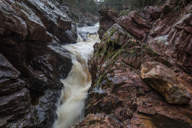
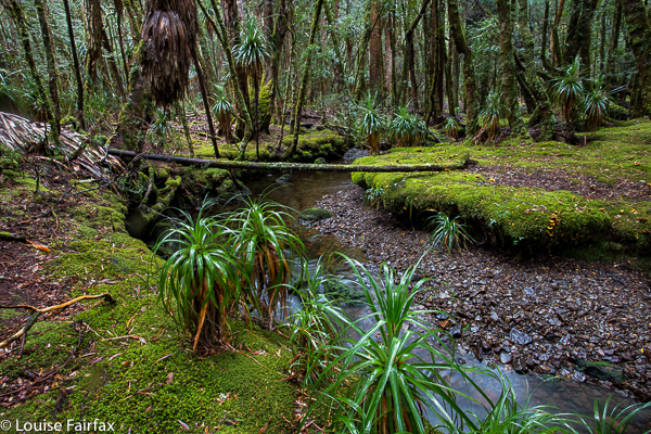
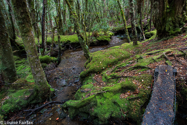
The Castra Cascades were pleasant enough, but not as beautiful as the many river scenes along the way, … and very shortly after that, we were at the junction of the Castra Rivulet we had been following, and Nietta Creek, which we were about to pursue. We’d been exercising for a total of 45 minutes at this stage (which included side trips, but not photos). This was a really pretty spot with a kind of beach – perfect for lunch. I ate hurriedly, as I wanted to explore a track that went off to the right here, to what was called a “Secret place”. I was unsure about where it went and what it was, as, unlike the other side routes, it gave no time estimation. I left Bruce quietly eating and set off along the steep banks on my mystery journey. After 16 minutes, the tapes seemed to have run out, and even if they hadn’t, I felt my time had. The scene below was what I found. I photographed just with hand-held camera on 1/10th second, as I feared Bruce might be getting cold and wondering what on earth his wife was up to. No longer wondering the whole time if this was the secret place, or this, I moved more quickly, and was back at the junction in 11 minutes.

I have thus called these the “Secret Place Cascades”. If someone wants to tell me their real name, I’d be most grateful. 

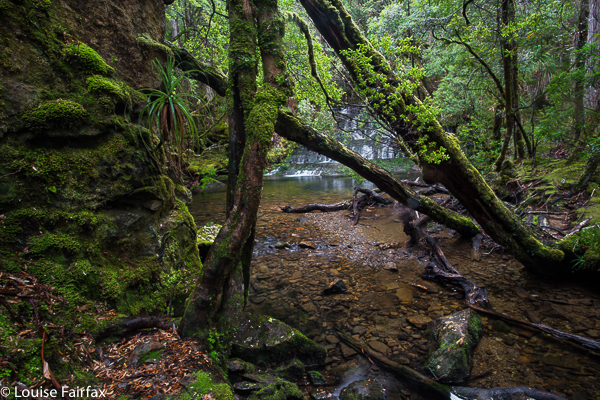
From the junction, the beautiful Nietta Creek is followed upstream until Silver Falls are reached. This part of the route is wonderful, as you are right beside the stream the whole way.

Nietta Creek

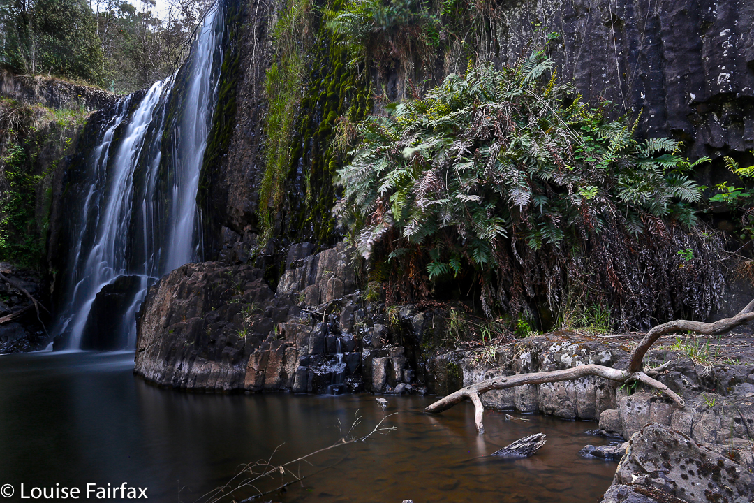
The side track to Silver Falls is the tiniest deviation from the circuit, and this was my favourite of the Falls. Another short but steep push and the top was reached.

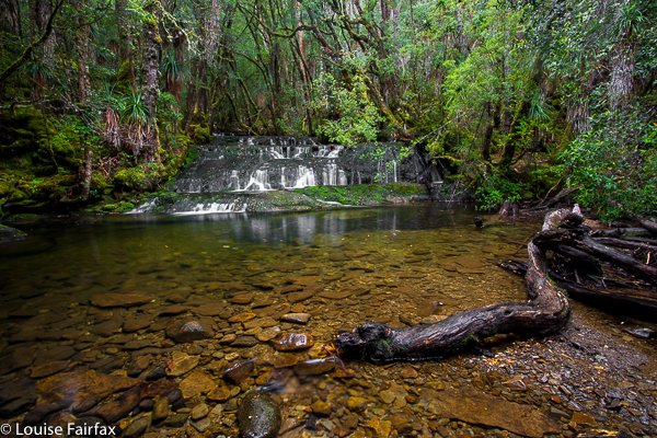
Silver Falls, falls number three


signage

 We had parked the car at the second entrance to the forest, maybe two hundred metres from the first, but the other side of the rivulet, in case the stream was flooded. As you can see from the photo below, it wasn’t, so we completed the circuit in the forest and were soon back at the car. (If the water is high, you can do this tiny stretch on the road.)
Apparently this beautiful circuit was destroyed in a huge storm a few years back, but has now been repaired by local volunteers, to whom go my heartfelt thanks. The tapes and path are clear, signage is fantastic, but, better than that, it remains a real bushwalk and not one of these wretched manicured tourist highways. You do have to concentrate a little; you can fall over or trip, you need to look for the next tape and use your brain a tiny bit. The freedom to fall or to make a slight error is a marvellous manumission in this over-cosseted, litigation-terrified age.

We had parked our car at the second forest entrance, and so finished with this creek crossing (over the Castra Rivulet) to end a perfect walk. (If you park at the first one, then this is about two minutes from the start).

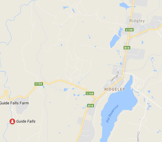
Our route. Hopefully you can see that there is a main circuit, with Falls off to the side, usually involving a climb down. Tasmaps, being their usual inefficient selves, have not only omitted the path, but have misnamed and misplaced the position of the falls in their habitual cavalier attitude to the needs of walkers and tourists who might want to use the maps for something purposeful. I have blocked out the incorrect names. We walked anti-clockwise. The narrative (combined with map reading) should make it clear which falls are which. Step Falls are correctly named and placed.


Just for fun, here is a graph of our altitude. Did I happen to mention there was a bit of up and down? Nice workout for the legs.

Dasher Falls 2016 Apr

Dasher Falls Apr 2016
We did Dasher Falls in combination with Redwater Creek Falls Upper and Lower – a pleasant short trip from Launceston.
(See www.natureloverswalks.com/redwater-creek-falls/ )


Dasher Falls
How to get there:  Driving from Sheffield, we turned towards Beulah at the intersection, along a road that the map (but not the signage) calls Bridal Track Road. We followed this along until there is a road off to the right at the bottom of the hill with a sign that says Lower Beulah 3 kms. This road crosses the Dasher River within 20 metres of the intersection. The falls are now about 400 ms upstream. You can either park there and walk up the road, or be lazy and do what we did and drive back up the hill for about 200+ ms until you see a pine tree with a pink tag on it. Parking there is fine pulling over to the left from this direction (but parking coming from the other direction and trying to spot tape etc didn’t appeal to us). From this tree, follow tapes towards the river, and then upstream to your right. Soon enough (a mere 100ms or less) you’ll see the falls. Today, after the heavy rain we’ve had, the mud and rocks were slippery, and my husband and dog both backed out of actually gong to the falls, settling for a walk back along the river on safer ground. I would not under any circumstances bring a child here unless it was on a lead! Maybe the picture is enough to tell you why. I was too scared to look over some edges.
After you’ve visited the falls, you can turn around by putting your nose into a dirt track that is on the right shortly after the pink-taped tree.

Cephissus Falls 2016 Mar

Cephissus Falls and Creek 2016


Normally I am rushing past the Cephissus Falls on my way to higher ground, but in March 2016, when we were on our way to climb Hyperion, the weather was so horrid we stopped short of our goal, and used the comfort of the hut for the night, This meant that I could spend some time at this beautiful waterfall, get out my tripod and see what I could capture. Unfortunately, the flow was less than exciting, but the lushness of the greens in this area always thrill me.


However, I mourn for this area already. Strident voices with a certain twang are complaining that the “facilities” of the hut are not up to scratch. They want more beds and more of … well, who knows what. I love it simple, just how it is, with what it used to have – genuine bushwalkers with stories to tell having fun in a remote place. I don’t want brash tourists who are clocking up comodified experiences and totalling this and that conquered place from some insta check list, rather than just listening to nature and enjoying it. Guide books are sending tourists there, and my beautiful little haven is no doubt going to be ruined by the building of some monstrosity like the replacement of Windy Ridge Hut – Bert Nichols I think it is now called. I hate it so much I won’t even eat lunch there. It has no soul, like the people who need such places in what used to be wilderness. We have sold our soul to tourists. Who cares for earthly riches when you have nowhere left for your soul to soar?

Philosopher Falls 2016 i Mar

Philosopher Falls 2016 i Mar

The beautiful path to the falls
It was raining. We were in no particular hurry to dash up to the Tyndalls, our ultimate objective for the day (and only a one and a half hour jaunt), so we decided it was perfect weather for visiting the Philosopher Falls, which were kind of en route.

The track unfortunately eschews the Arthur River for most of the way, but you do get to cross it at this point. 

The Tarkine here was beautiful and, to my delight, the first of the autumn fungi were starting to appear, set in a context of lush green ferns, moss and lichens. We were excited, but this was marred somewhat by our arrival at the end of the track, which dumped us at the TOP of the falls. Who wants to see a gaping hole with a bit of white splash, hinting at the real thing below? Not me, and not any of the other tourists we met. All reported disappointment.

Being a little more obstinate than your average, I decided to rectify this matter by climbing down the very steep cliff below me (so steep you couldn’t actually see where it went), despite the fact that my camera gear was around my neck, swaying and banging and not in a rucksack, and that I was only wearing runners. Bruce at least had on boots, but is not exactly equipped for such Tarzan acts these days. Down we plummeted, hoping for a controlled landing, and not a death-inducing lurch should one of the branches decay in our hands. (Sorry reader. They’ll no doubt now put up one of those huge ugly notices warning you that this is dangerous, as if you didn’t have the brains to work that out for yourself.)

Landing down by the Arthur River (and still alive at this stage), we still couldn’t reach the falls – or not dressed in the clothes we had on, and not with Bruce, whose capabilities had already been more than tested by this stage; I don’t think too many able-bodied people have lowered themselves down that cliff. I made a tactical withdrawal, and returned to the top, so tense with the responsibility of choosing a route suitable for my husband that I didn’t even photograph the magic fairyland through which we moiled. If you have information on how to get to a spot where you can actually see these falls, I would be most appreciative.

To add insult to defeat, the sun came out, so it was totally useless taking a photo of the tiny bit of splash you were allowed to see. I departed empty handed, but with some fungi shots that I rather love. Hope you do too.


Guide Falls 2015 Dec

The Guide Falls are only a short distance from Burnie. Head south on the B18 towards Ridgley, after which you’ll see a clear sign pointing you in the right direction (initially, on the C104). These Falls were delightful, although I hated seeing the old-fashioned wire and steel railing to keep me from falling off the edge.

Guide Falls, near Burnie